Seen from Space 2004
First Hurricane over the South Atlantic
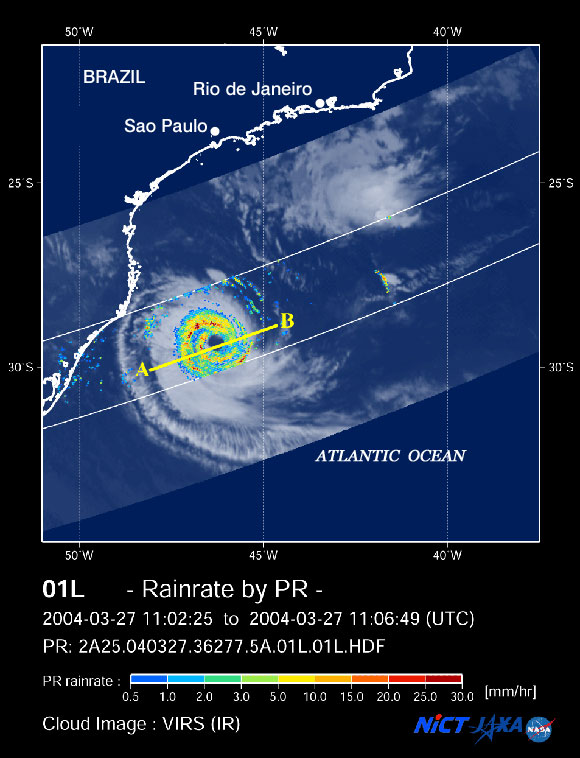
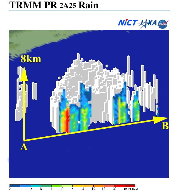
A hurricane was observed over the South Atlantic, where no tropical cyclone observed at all since 1960s when meteorological satellite observation began. This extremely rare hurricane has observed by the Tropical Rainfall Measuring Mission (TRMM) satellite and the Aqua satellite. It was born east of Brazil on March 25, then moved westward as it grew, eventually hitting Santa Catorina, Brazil. Figure 1 indicates the rain rate near the surface observed by the Precipitation Radar, PR(*1), on board the TRMM satellite, overlaid with cloud images derived from the Visible Infrared Scanner, VIRS. Red represents intense rain. There is no rain in the center of the hurricane. Figure 2 depicts the three-dimensional rainfall structure acquired by PR observation and precipitation along A to B in Fig. 1. The top of the rainfall isn't so high, about 8km, but you can find intense rainfall areas (red, yellow and green) outside the eye in this figure. Figure 3 illustrates the water vapor content of air observed by AMSR-E on board the Aqua satellite. Heavy rain can occur where the water vapor content of air is high. You can see much water vapor in the air (red and yellow) is distributed in a spiral around the hurricane (*2). This hurricane has the typical structure of a tropical cyclone because of the intense rain outside the eye and the large volume of water vapor contained in the air.
Hurricanes are considered unlikely to occur over the South Atlantic because wind speeds between upper air and lower air are very different(*3); this also applies to this case. It seem that a temperate cyclone changed and developed into a tropical cyclone. Scientists question whether this cyclone can be defined as a regular hurricane or not. (*1) Precipitation Radar (PR) is a sensor for measuring precipitation from the intensity of received radio signals emitted from PR and scattered by rain particles. PR was developed to be flown on board satellite platforms. It was the first of its type in the world and was developed by the National Institute of Information and Communications Technology (NICT; the former Communication Research Laboratory (CRL)) and the Japan Aerospace Exploration Agency (JAXA; the former National Space Development Agency of Japan (NASDA)) by applying ground-based meteorological radar technology. (*2) The gray area in the center of hurricane indicates that AMSR-E is unable to estimate water vapor content because of the heavy rainfall. (*3) The conditions for hurricane generation are a sea-surface temperature exceeding 27 degrees (except near the equator), a small difference of air temperature between north and south, and a small difference of wind speed between upper and lower air masses. Low latitude sea areas, excluding the South Atlantic and South Pacific near Peru, generally satisfy these conditions.
|