Seen from Space 2003
Smoke of Siberian Forest Fires Reaches Alaska
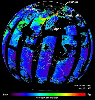
--- First Land and Ocean Aerosol Distribution with GLI Near-ultraviolet 1 km Resolution Band ---
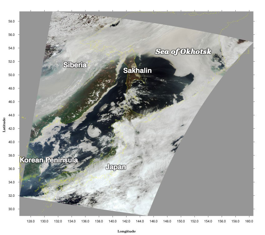
GLI captured the smoke of large-scale forest fires burning in Eastern Russia in the spring of this year. The smoke passed through Eastern China and the Western Pacific and eventually reached Alaska. GLI aboard ADEOS-II (Midori-II) was able to capture the global aerosol distribution (including over land) for the first time because of its near-ultraviolet channel (380 nm) with a 1 km spatial resolution and its wide observation swath of 1,600 km. Figure 1 presents the aerosol concentration based on GLI data acquired on May 19, 2003 (*). Aerosols are microscopic particles suspended in the atmosphere and have a large variety of species and sources, such as gas exhausted from cars and plants, dust from deserts, sea salt particles from the oceans, and smoke from forest fires and slash-and-burn agriculture. Figure 1 depicts the eastern half of the Eurasian Continent, the Northern Pacific Ocean and parts of North America. It indicates that the highly dense aerosol (yellow and red) originated near Lake Bajkal in Siberia and spread to Alaska after passing northwest of the Kamchatka Peninsula. Black indicates screened-out cloudy regions or areas where no observations were made. Scientists study the global aerosol distribution and transport to understand the impacts on global climate change. GLI captured the global aerosol concentration including the distribution over land with high spatial resolution in the near-UV band for the first time. Figure 2 is a true-color image of the area near Japan using GLI channels 13, 8, and 5. The colors in a true-color image resemble those seen by the human eye. Figure 2 also clearly shows the smoke over the Korean Peninsula, eastern Russia and northern Sahalin (grey part), corresponding to Fig. 1.
Additionally, the Topic "Smoke from Fires Drifting into Northern Japan" dated May 23, 2003, indicates that the smoke from a number of fires in eastern Russia is drifting into northern Japan and Sahalin. (*) The aerosol concentration is calculated from the ratio of GLI channel 2 (400 nm) and channel 1 (380 nm) reflectances. The full resolution of GLI is 1 km, but for a global view the data are aggregated to a 0.125 degrees resolution. |