Seen from Space 2003
Death Valley: Thwarting Pioneers' Dreams
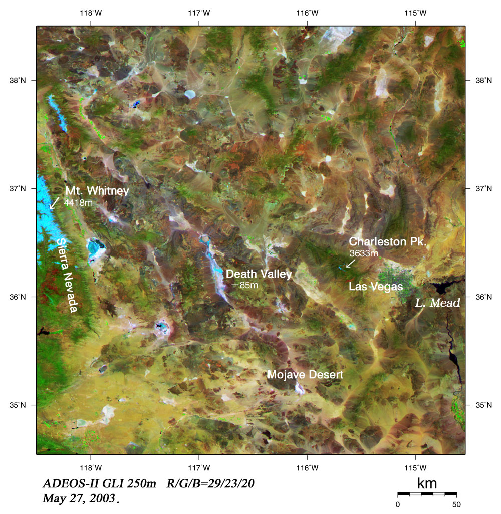
There is a valley called the Death Valley between California and Nevada in the United States of America. It may be better to regard it as a large basin rather than a valley because it is 160km long (1.5 times as long as Okinawa), 8 to 24km wide, but only 85m below sea level. At the bottom of the valley, there is "bad water" that pioneers could not drink because it held too much salt. The area contains the lowest point in North America. Death Valley is separated from the Pacific Ocean by the Sierra Nevada mountains and is surrounded by high mountains. It rarely rains, and the average maximum temperature of July reaches up to 46°C. It is said to be named "Death Valley" because pioneers traveling to California lost their way and died here in the Gold Rush of 1849. GLI captured this image of Death Valley. Light blue at the bottom of the valley indicates salty water. An interesting characteristic is that at Charleston Peak, more vegetation can be seen at the top of the mountain than at the foot. Brown, skin-color, and light violet parts indicate abundant varieties of rock or sand. In the east of Death Valley, towns around Las Vegas can be seen neatly in a grid among rich vegetation. The Colorado River and Lake Mead provide this dry area with invaluable bounties of water for people living here. On the left side of the image, snow-covered Mt. Whitney, the highest mountain in mainland America, can be seen in light blue. From the image, we can also see rich vegetation caused by rain in the mountains spreading around the west coast. Explanation of the image Sensor: Global Imager (GLI) Date of observation: May 27, 2003 This image was generated from GLI spectral channel 29 (2210nm) in the short-wavelength infrared band (red), channel 23 (825nm) in the near-infrared band (green), and channel 20 (460nm) in the visible band (blue). Vegetation has a strong green coloration because the near-infrared band that reflects vegetation significantly was colored green. Furthermore, because the short-wavelength infrared band that is made less reflective by hydroxyl or carbon base was colored red, those areas have strong blue or green coloration. GLI spectral channels can be applied to search for valuable metallic ore deposits such as gold formed around hot springs and hydrothermal deposits. |