 |
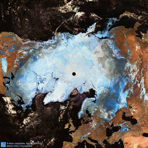
This image shows a nine-day composite, cloud-free image of the northern polar region composed of GLI Level-1B data and acquired April 2-10, 2003. The Japanese islands (upper right), Caspian Sea and Black Sea (lower right), Europe (lower left), and North America (upper left) can be seen. Snow and seaice are represented in turquoise and clouds in white. Open water (ocean and lake) is black. (The black circle at the North Pole is the region not observed by GLI.)
Vast seaice in the Arctic Ocean, and snow cover over tundra and mountainous regions in Alaska, Canada and northern Siberia appear in spring. Dark turquoise around the taiga region in Siberia also indicates an area covered with snow under deep forest.
Open ocean without seaice extends up to relatively high latitudes from east of Greenland to north of the Scandinavian Peninsula. The Norwegian Current that branches off from the warm North Atlantic Current always keeps the ocean area warmer than other areas at the same latitude, so that seaice does not develop there even in winter.
In contrast, seaice is found in the Sea of Okhotsk at relatively low latitudes. A large amount of fresh water flows from the Amur into the Sea of Okhotsk. The Kuril Islands prevent the Sea of Okhotsk from mixing with the Pacific Ocean. These geographical features help keep seaice there even in spring. The Sea of Okhotsk is thus the southern limit of seaice extent in the northern hemisphere.
Due to global warming, spring seaice in the Arctic Ocean is considered to recede earlier year-by-year. Permafrost in the tundra is also expected to decrease. The cryosphere is the most sensitive to changes in the global climate. Thus, it is very important to monitor snow and ice coverage in the northern and southern hemispheres in order to detect a early signs of climate change.
This false-color image is produced by assigning GLI Band 26 (1240nm) to the red channel, Band 24 (1050nm) to green channel and Band 19 (865nm) to blue channel. |


