


1) Digital Elevation Model (DEM) and Mapping | 2) Land Use Monitoring and Land Cover Classification | 3) Disaster Monitoring | 4) Geological Surveying and Mineral Resource Exploration | 5) Terrestrial Ecosystem and Forestry Management | 6) Oceanography and Coastal Zone Related Research | 7) Snow and Ice Related Research | 8) Agriculture Management | 9) Hydrology and Water Resource Management | 10) Application Research using Geographical Information | 11) PRISM / AVNIR-2 | 12) PALSAR | 13) Thailand (JAXA-GISTDA collaboration)
PALSAR
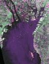
Around Nagoya, Japan image observed by PALSAR (Polarimetric) on Apr. 26, 2006.
AVNIR-2
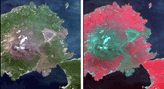
Sakurajima Island, Kagoshima Pref., Japan observed by AVNIR-2 on Jun. 20, 2006.
PRISM
AVNIR-2
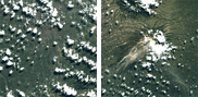
Pan-sharpen image of Mt. Merapi and Yogyakarta, Java, Indonesia generated by AVNIR-2 and PRISM with active high-speed viewer "ZOOMA".