


1) Digital Elevation Model (DEM) and Mapping | 2) Land Use Monitoring and Land Cover Classification | 3) Disaster Monitoring | 4) Geological Surveying and Mineral Resource Exploration | 5) Terrestrial Ecosystem and Forestry Management | 6) Oceanography and Coastal Zone Related Research | 7) Snow and Ice Related Research | 8) Agriculture Management | 9) Hydrology and Water Resource Management | 10) Application Research using Geographical Information | 11) PRISM / AVNIR-2 | 12) PALSAR | 13) Thailand (JAXA-GISTDA collaboration)
PRISM
AVNIR-2
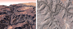
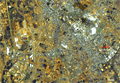
Pan-sharpen image using PRISM (on Jun. 18, 2006) and AVNIR-2 (on May 10, 2006) images over Grand Canyon, U.S..
PRISM
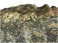
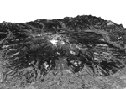
Three-Dimensional View of Mt. Aso in Japan, using PRISM on Mar. 23, 2006.
PRISM
AVNIR-2
Pan-sharpen image over Saitama Pref., Japan observed by PRISM and AVNIR-2 on April 30, 2006 with active high-speed viewer "ZOOMA".
PRISM
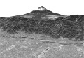
Three-Dimensional View of Mt. Fuji using PRISM.
PRISM
AVNIR-2
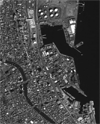
Pan-sharpen image around Tsukuba City, Ibaraki Pref., Japan observed by AVNIR-2 on March 25, 2006 and PRISM on March 27 with active high-speed viewer "ZOOMA".
PRISM
AVNIR-2
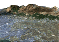
Pan-sharpen image with generated digital surface model (DSM) using PRISM and AVNIR-2 images over Kujyu mountain range, Oita Pref., Japan.
PRISM
PRISM image observed over west part of Chiba Prefecture, Japan on Mar. 27, 2006 displayed by "ZOOMA", which is innovative and active high-speed viewer. It can be useful to see high-resolution image. When you browse for the first time, the viewer will be automatically set with free of charge.
PRISM
AVNIR-2
Pan-sharpen image with generated digital surface model (DSM) using PRISM and AVNIR-2 images over Mt. Aso, Kumamoto Prefecture, Japan.
PRISM
The image data of Mt. Haruna was observed by the PRISM on Feb. 14, 2006.
PRISM
The image data of Mt. Fuji was observed by the PRISM on Feb.14, 2006 and a three-dimensional movie compiled from observed images.
PRISM
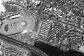
The image data of Shimizu Port near Shizuoka city was observed by the PRISM on Feb.14, 2006