


1) Digital Elevation Model (DEM) and Mapping | 2) Land Use Monitoring and Land Cover Classification | 3) Disaster Monitoring | 4) Geological Surveying and Mineral Resource Exploration | 5) Terrestrial Ecosystem and Forestry Management | 6) Oceanography and Coastal Zone Related Research | 7) Snow and Ice Related Research | 8) Agriculture Management | 9) Hydrology and Water Resource Management | 10) Application Research using Geographical Information | 11) PRISM / AVNIR-2 | 12) PALSAR | 13) Thailand (JAXA-GISTDA collaboration)

Sep. 13, 2017
Aug. 9, 2017
Jul. 25, 2017
PALSAR-2
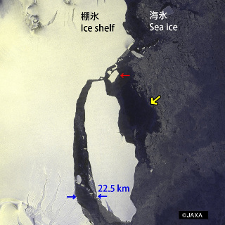
ALOS-2/PALSAR-2 Observation results on detachment of a large iceberg from Larsen-C Ice Shelf in Antarctic Peninsula. [Update on Oct. 12, 2017]
PALSAR
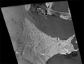
Sea of Okhotsk and Sea ice, image data acquired by PALSAR (ScanSAR) during the night on Apr. 18, 2006.