| |
|
|
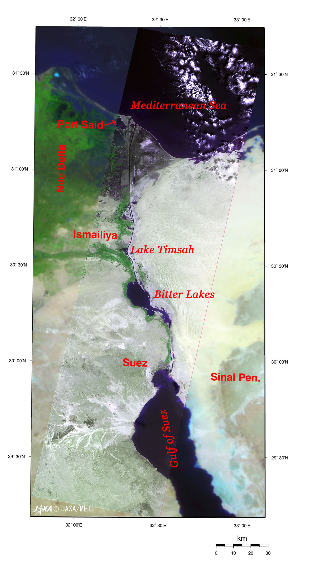
Fig. 1 the Suez Canal observed by VNIR |
|
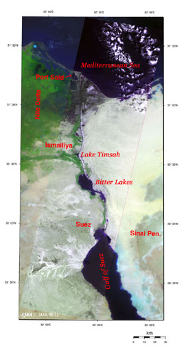
Figure 1 depicts the Suez Canal observed by the Optical Sensor aboard Japanese Earth Resources Satellite-1 (Fuyo-1). The Mediterranean Sea in the upper part of the figure is shown in black, and the lower part of the figure shows the Gulf of Suez, also in black, connecting with the Red Sea. The Suez Canal extends from Port Said, the harbor city on the Mediterranean Sea side, to Suez, the commercial city on the Red Sea side, via Lake Timsah and the Bitter Lakes, making its total length 195 km, including the approaching waterway facilities around the entrances. The tidewater causes a damp area around the outskirts of Port Said to appear black. Because water levels on the Mediterranean Sea side and the Red Sea side are similar, the Suez Canal has no water gates to allow for differences in water levels like the Panama Canal. |
On the eastern side of the Suez Canal, the arid land stretches into the Sinai Peninsula.
On the western side, the Nile Delta is close by, and you can see the green farms irrigated with water drawn from the Nile.
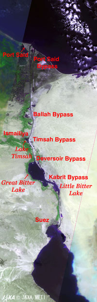 |
| Fig. 2 Expanded image of the Suez Canal |
|
Figure 2 demonstrates that most of the Suez Canal is single lane only. There are only five sections (bypasses) where bi-directional navigation is possible. For this reason, ships pass through the canal in a fleet of 10 to 15 ships in single file. It takes an average of 15 hours to pass through the canal. The canal was closed for three days when a tanker ran aground in November 2004. This was the longest closure during the last 30 years since the reopening in June 1975. In November 1869, when construction on the Suez Canal was first begun by Count De Lesseps, a French diplomat, the waterway measured 44 m wide and 10 m deep. The first expansion project of the Suez Canal from 1975 to 1980 was the greatest scale in expansion construction. On that occasion, the Japanese government implemented ODA (Official Development Assistance) Loans, and technologies of Japanese private enterprise were used. As a result, the width of the waterway was expanded from 89 m to 160 m, and the depth from 14.5 m to 19.5 m, allowing 150,000-ton class tankers to pass through the canal instead of the previous limit of 50,000-ton class ships.
|
Other expansion projects were conducted later, and the current waterway is 200 to 210 m wide and 22.5 m deep, allowing 250,000-ton class tankers with a draft of 22 m to pass through the canal.
About 15,000 ships pass through the Suez Canal each year. This corresponds to 7% of the world's marine transportation. Twenty-two percent of the ships are oil tankers, and 44 % are containerships (based upon aggregate tonnage as of 2003). In Egypt, the Embassy of Japan reports that previously there was a larger percentage of oil tankers. However, recently the percentage of containerships has increased because Ultra Large Crude Carriers (ULCCs) of more than 300,000 dead weight tons went into service traveling via the Cape of Good Hope, bypassing the canal. The capacity of the Suez / Mediterranean Sea Pipeline (SUMED) has increased but the number of passing oil tankers has decreased, while the trade between Asia and Europe has also increased.
According to the income of the Suez Canal Authority in 2004, the passing fees were estimated at 3 billion dollars, a record-high (330 billion yen), and it is an important source of foreign currency income for Egypt.
Explanation of the images:
Figs. 1 and 2
| Satellite : |
Japanese Earth Resources Satellite -1 (JERS-1) |
| Sensor : |
Visible and Near Infrared Radiometer (VNIR) |
| Date : |
0851 (UT) on May 9, 1996 |
| Ground resolution: |
18.3 m x 24.2 m |
| Map Projection: |
Universal Transversal Mercator |
| Figures 1 and 2 are made by assigning red to the visible channel (0.63 to 0.69 µm), green to the near-infrared channel (0.76 to 0.86 µm), and blue to the visible channel (0.52 to 0.60 µm). As a result, all the figures have a natural coloring, with vegetation slightly emphasized and look as though seen with the naked eye. In these images, clouds are white; exposed rock, soil and sand are white or pale brown; city areas are gray; vegetation is vivid green; water surfaces are black; and wetlands are blackish. |
Area surrounding Figs. 1 and 2
| Satellite : |
ADEOS-II (Midori-II) |
| Sensor : |
Global Imager (GLI) |
| Date : |
May 10, 2003 |
| Ground resolution: |
250 m |
| Map Projection: |
Universal Transversal Mercator |
| Color composition was made by using GLI 250 m resolution channels, and assigning red to mid-infrared channel 29 (2,210 nm), green to near-infrared channel 23 (825 nm) and blue to visible channel 21 (545 nm). In these images, clouds are white, soil and exposed rocks are brown, vegetation is green, water surfaces are black, and salt soil is light blue. |
|
|
|
Related Sites:
 Circular Farms and Impact Craters in the Sahara Circular Farms and Impact Craters in the Sahara
The Gift of the Nile: Egypt
Appendices:
The Shortcut Effect:
The route between London and the Persian Gulf is 11,300 nautical miles (20,900 km) via the Cape of Good Hope off the southern tip of Africa, but it is 6,400 nautical miles (12,000km) via the Suez Canal; 43% shorter. Navigating at 20 knots, it takes 24 days via the Cape of Good Hope, but only 14 days via the Suez Canal. One nautical mile (nm) =1,852 m = length of one minute of the meridian, and 1 knot =1 n.m. / hour.
The route between London and Yokohama is 14,500 n.m. (26,900km) via the Cape of Good Hope, but 11,000 n.m. (20,400km) via the Suez Canal; 24% shorter. It takes 23 days via the Suez Canal, which is seven days less than the route via the Cape of Good Hope when navigating at 20 knots.
The History of the Waterway before Count De Lesseps:
The concept to link the Mediterranean Sea and the Red Sea using a waterway is not a new idea. The oldest evidence on record indicates that a canal linking the Pelusian branch of the Nile to the northern end of the Bitter Lakes was built during the reign of Necho II (610 to 595 BC) of the 26th dynasty in Egypt. It was later abandoned and rebuilt repeatedly. It was then closed to stop the supply route of a rebel army in 767 AD. Napoleon Bonaparte first examined the modern canal construction plan in 1799, reflecting the result of his expedition to Egypt. However, due to a calculation error, the results showed that the water level of the Mediterranean Sea was 9 m lower than that of the Red Sea, so the plan was promptly canceled.
|