Seen from Space 2005
Giant iceberg "B-15A" crushes ice tongue
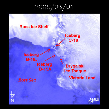
In April of this year, a giant iceberg adrift in the Ross Sea crushed an ice tongue. The movement of this iceberg was traced by a microwave sensor AMSR-E (situated on Aqua, an Earth-observation satellite of NASA). The Ross Sea is represented in Fig. 1 by the blue hatched part in the bottom left. The Ross Ice Shelf in the upper left is white, and Victoria Land is the white part in the lower right. The top of the figure is oriented south, and the bottom is oriented north. In the center of Fig. 1, we can see giant iceberg B-15A drifting slowly north along the coast of Victoria Land. Between April 10 to April 15 of this year, B-15A collided with the Drygalski Ice Tongue and crushed its top. After the collision, B-15A drifted away from the ice coast and moved slowly to the north. In Fig. 1, we can also see giant square iceberg B-15J spinning near the coast of the Ross Ice Shelf.
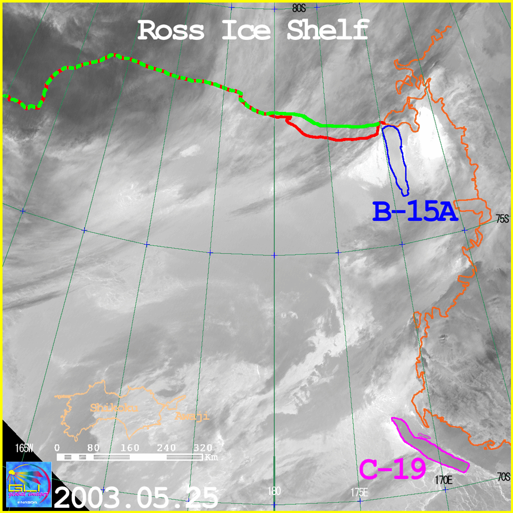
B-15A comes from the Ross Ice Shelf, a huge Antarctic glacier jutting out over the Ross Sea. In March 2000, the ice coast of the Ross Ice Shelf broke into a giant iceberg B-15 (previously referred to in our document "Whereabouts of Giant Iceberg" in June 2003). B-15 in the iceberg name means the fifteenth iceberg born in B quadrant of Antarctica (between 90 degrees west longitude and 180 degrees west longitude). When an iceberg breaks into pieces, those pieces are named with endings such as "-A" and "-B." The name B-15A means the largest piece of iceberg comes from the primary iceberg B-15. After the birth of iceberg B-15A in 2000, the clockwise rotating ocean current in the Ross Sea brought it slowly along the edge of Ross Ice Shelf to the west where it collided with another iceberg C-16 at about longitude 170 degree east. B-15A had been fixed there since that time. We estimate this long-term immobility of B-15A was due to B-15A being in the shallow area of the ocean. The ocean current pressed B-15A against C-16, in the Ross Sea which is icebound in winter with thick floating ice. B-15A maintains its giant size, 120km in length and 30km in width, even though it has divided many times, (figuratively speaking, it is almost same as long and three times as thick as Okinawa Island) . We expect B-15A will drift north continuously away from the Ross Sea like the giant iceberg C-19 (referred to in our document "Whereabouts of Giant Iceberg" in June 2003). Icebergs cool seawater around them, so some scientists are worried about undesirable influences upon the ecosystem of penguins there due to the close drift of this giant iceberg. JAXA will continue to monitor such trends of icebergs using Earth-observation satellite.
Related sites: |
|||||||||||||||||||||||||