Seen from Space 2005
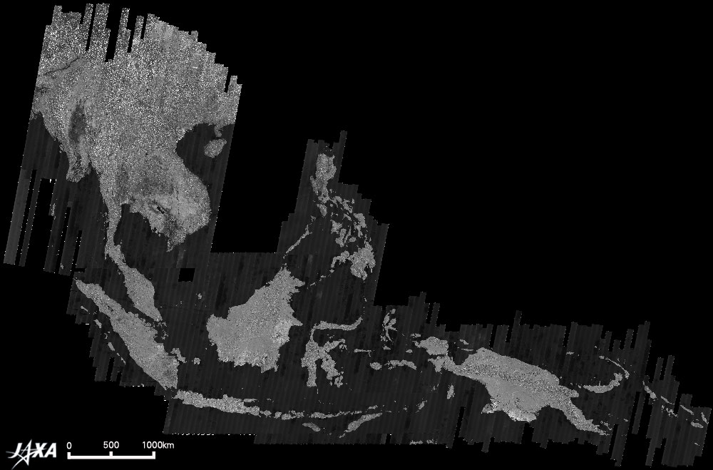
JERS-1 SAR mosaic covering Insular South-East Asia
The image shows a mosaic of South-East Asia, as observed by the radar (SAR) instrument aboard the Japanese Earth Resources Satellite-1 (JERS-1) between 1992 and 1998. The mosaic covers a very wide area from Myanmar in the west to the Solomon Islands on the east, extending approximately 8,000 km in distance, or some 70° in longitude. The brightness of the image indicates how much of the microwave signals transmitted from the SAR were reflected on the earth surface back to the satellite. Water surfaces such as the sea or lakes, appear dark as almost nothing of the transmitted signals are reflected back to the satellite. Conversely, artificial structures such as buildings in big cities like Bangkok and Jakarta provide strong targets for reflection, and thus look very bright. Forests, in turn, reflect the radar signals in many directions and therefore appear in various tones of grey, depending on the density of the forest. JAXA EORC has just released a CD-ROM set (SEA-2) containing fine resolution radar image mosaics generated from JERS-1 SAR data. SEA-2 features the entire insular region of South-East Asia, including Indonesia, Malaysia, Singapore, Brunei, East Timor, the Philippines, Papua New Guinea and the Solomon Islands. The completion of SEA-2 follows that of the SEA-1 CD-ROM set, which covers the mainland part of South-East Asia mainland from Myanmar to Vietnam and Malaysia in 2003. The mosaics are available at 100 m, 500 m and 2 km ground resolution. These regional-scale mosaics were produced as a part of the JERS-1 SAR Global Forest Mapping (GRFM/GBFM) project, an international collaborative project led by JAXA which is set out to generate fine resolution mosaics over the entire tropical and boreal zones of the Earth. Within the GRFM/GBFM project, mosaics have been generated over: Mainland South-East Asia vol. 1 (SEA-1) Insular South-East Asia vol. 2 (SEA-2) Equatorial Africa (AFR-1) South America (Amazon Basin) (AM-1, AM-2) Central America & Pantanal (AM-3) Boreal North America (NA-1) Mosaics at 500 m and 2 km resolution can be viewed on-line at "The JERS-1 SAR Global Forest Mapping (GRFM/GBFM) Program." To view the 100 m resolution versions of the mosaics, you need to order a CD-ROM. Send a message to the ALOS/JERS-1 secretariat at e-mail:ALOS/JERS-1 secretariat with information about your name, address and desired CD-ROM, together with a short description of what you intend to use the data for. Note that the GRFM/GBFM CD-ROM data sets are provided free of charge, but are available for research and educational purposes only.
Related sites: |
||||||||||||||||