
ALOS-2/PALSAR-2 Observation Result for Eruption of Mt. Kilauea and Earthquake in Hawaii (4)
Posted: Jun. 22, 2018, 9:00 (UTC)
Overviews
- Mt. Kilauea in Big Island, Hawaii, has been erupting since May 3.
- JAXA has performed emergency observations by ALOS-2 (“DAICHI-2”) since June, 2018, and captured surface displacement around Halemaumau Crater and area of lava flow around Leilani Estates.
- The observation data were provided to local institutions. ALOS-2 will be able to be contributed to monitor volcanic activity regardless of clouds, volcanic plumes, and sun light.
| Observation time (UTC) | Orbit number | Observation mode | Polarization | Observation direction | Beam number | |
| ① | June 11, 2018 | 93 | Spotlight | HH | Right | - |
| ② | June 13, 2018 | 85 | Spotlight | HH | Left | - |
| ③ | June 14, 2018 | 186 | Stripmap 10m | HH+HV | Right | F2_5 |
| ④ | June 16, 2018 | 94 | Spotlight | HH | Right | - |
| ⑤ | June 19, 2018 | 89 | Stripmap 10m | HH+HV | Right | F2_6 |
*Please see ALOS-2/PALSAR-2 Observation Result for Eruption of Mt. Kilauea and Earthquake in Hawaii(3) for observations between June 1 and 9, ALOS-2/PALSAR-2 Observation Result for Eruption of Mt. Kilauea and Earthquake in Hawaii(2) for observations between May 22 and 30, and ALOS-2/PALSAR-2 Observation Result for Eruption of Mt. Kilauea and Earthquake in Hawaii for observations before May 22.
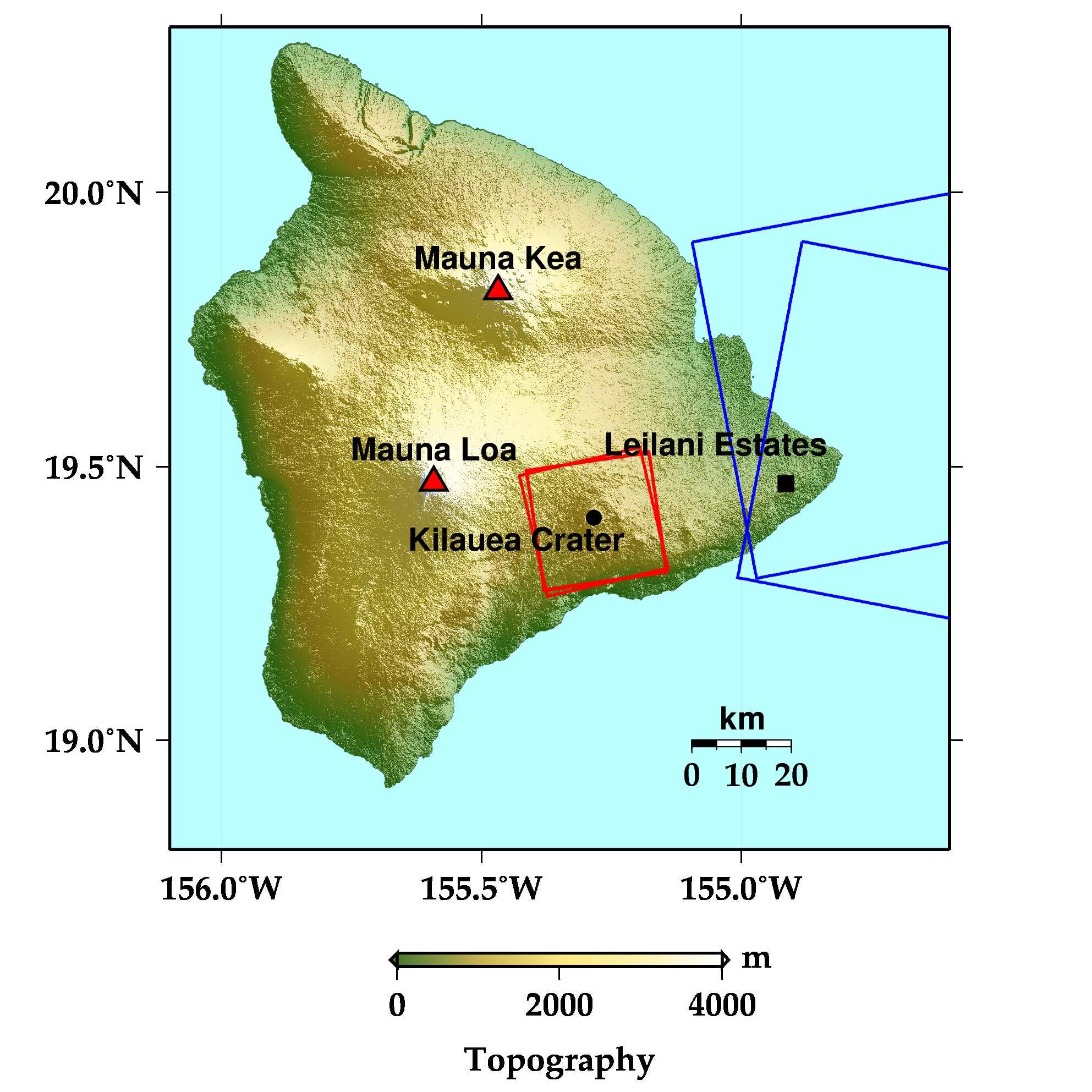 Fig. 1: Topography on Big Island and the observation area by ALOS-2. The red rectangle shows the area by Spotlight mode and the blue one does that by Stripmap mode in Table 1.
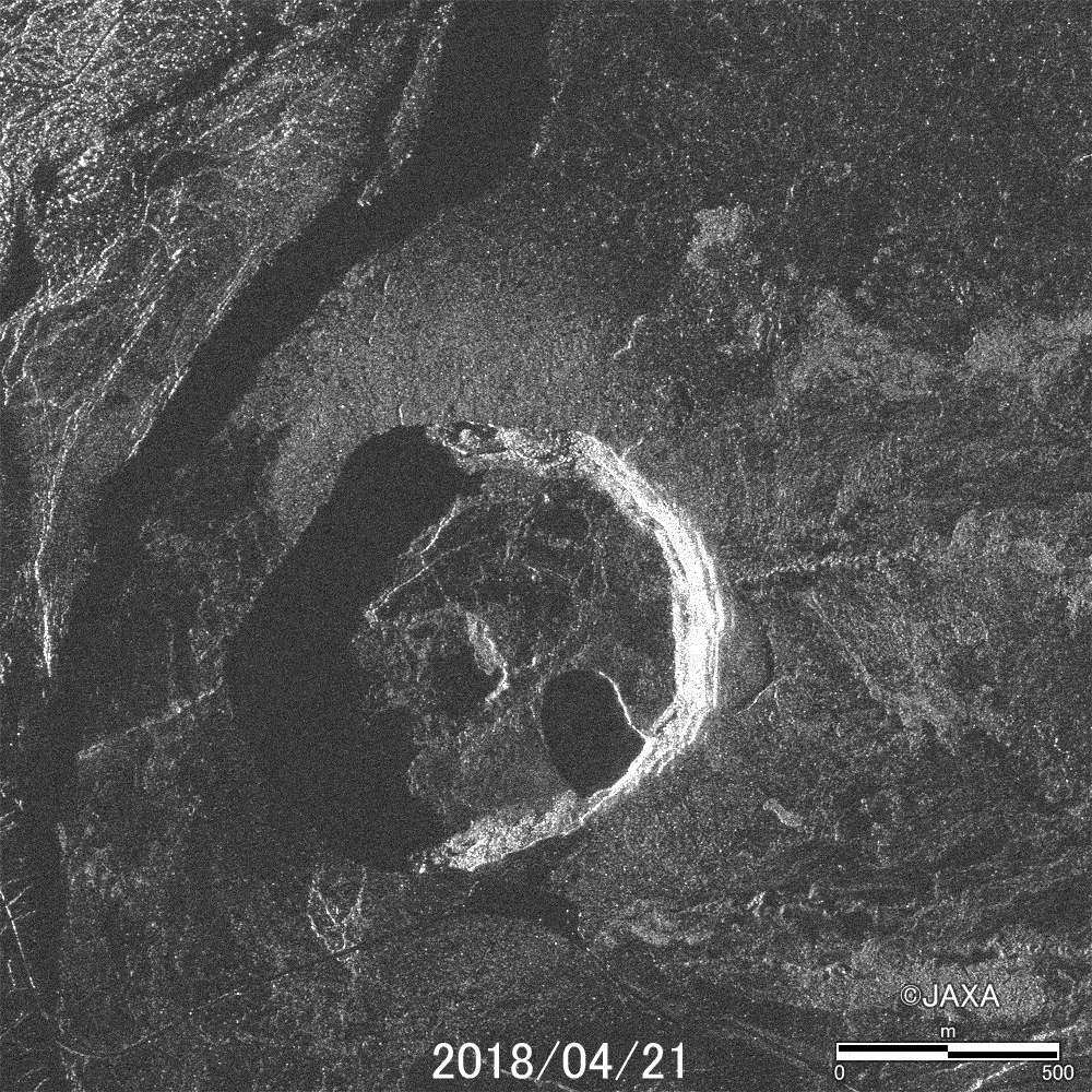 Fig. 2: Animation of ALOS-2 PALSAR-2 images around Halemaumau Crater.
(Click to view enlarged image)
Figure 2 is an animation around Haleamumau Crater using ALOS-2 PALSAR-2 images acquired on April 21, June 11, and Jun 16, 2018. These images show the process of subsidence and collapse in the crater.
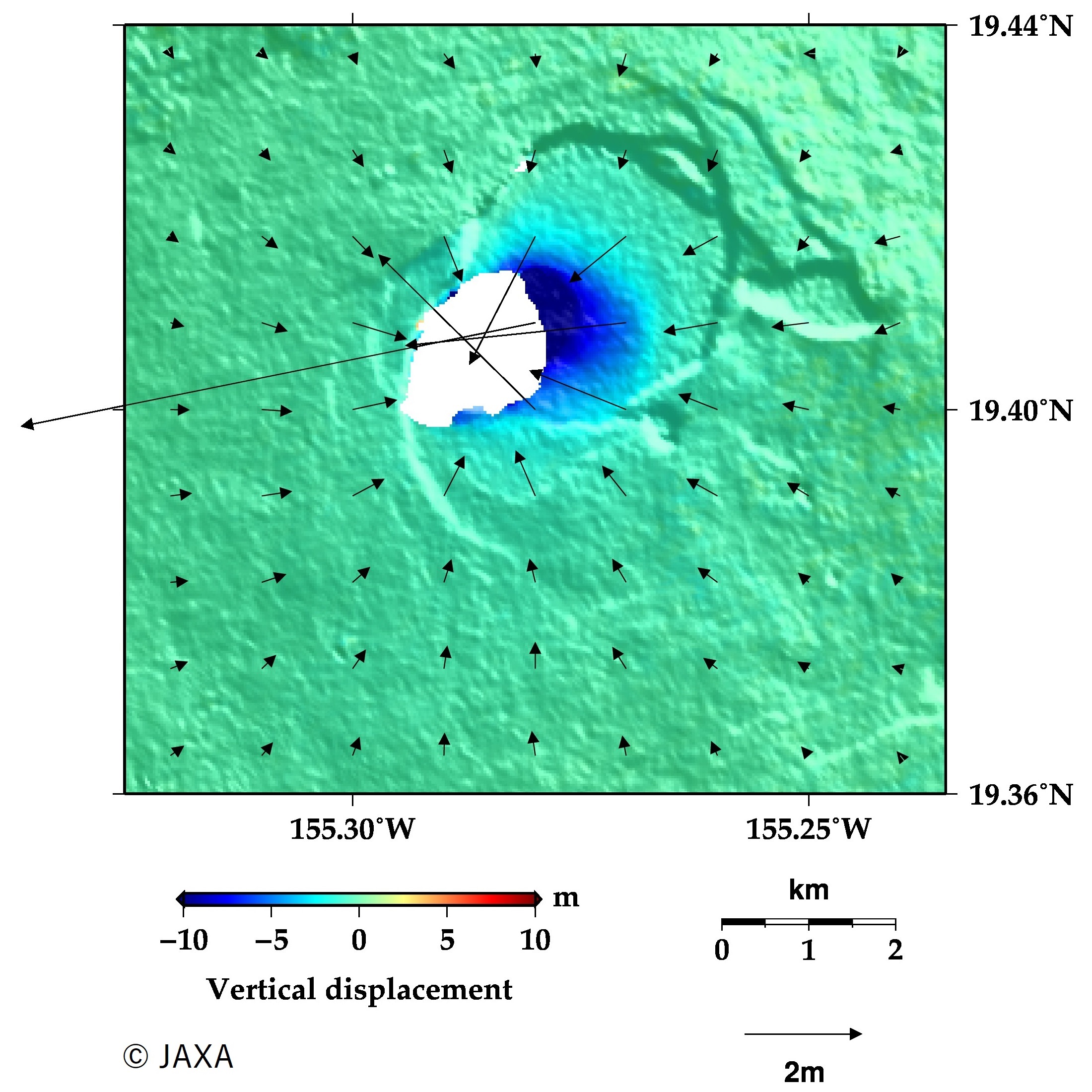 Fig. 3: Three-dimensional deformation around Halemaumau Creter derived from two pixel-offset results.
(Click to view enlarged image)
Figure 3 shows three-dimensional displacement field around Halemaumau Crater revealed by two pixel-offset results (April 16 and June 11, 2018, and February 10, 2016 and June 13, 2018). The vectors and contour show the horizontal and vertical displacement. The result shows the horizontal displacement up to 9 m and the subsidence up to 17 m, respectively.
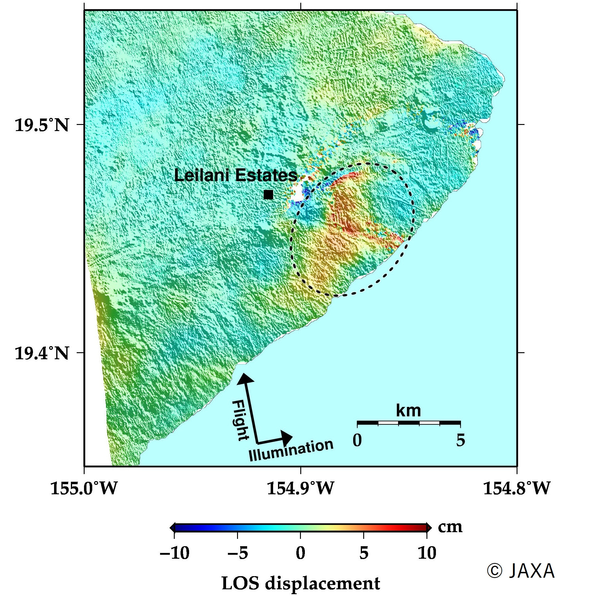 Fig. 4: An interferometric image of the ALOS-2 PALSAR-2 data acquired on May 22, 2018 and June 19, 2018.
(Click to view enlarged image)
Figure 4 shows an interferogram using the ALOS-2 PALSAR-2 data acquired on May 22, and June 19, 2018. This image shows ~10 cm displacement away from the satellite (subsidence or eastward) around in Leilani Estates (white-dotted circle). The distribution of the displacement coincides with that of the lava flow, which may imply the surface depression due to lave cave compaction.
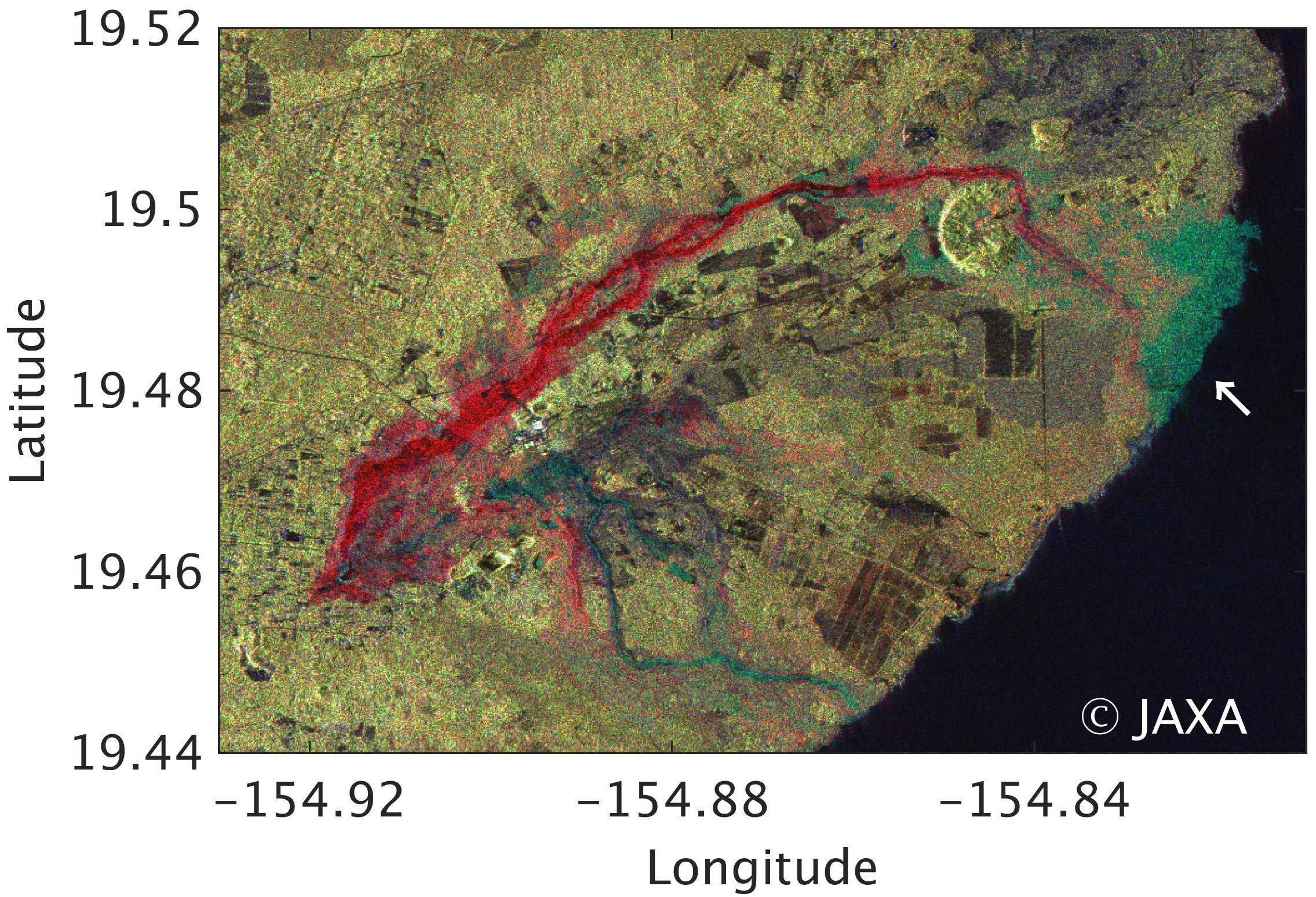 Fig. 5: Polarimetric color-composite image of the ALOS-2 PALSAR-2 data acquired on May 22 and June 19, 2018, around Leilani Estates.
(Click to view enlarged image)
Figure 5 shows a color-composite image (red: May 22 HV polarization, green: June 19 HV pol., blue: June 19 HH pol.) where eruptive fissures and lava flow can be seen in red color. This image shows the area of lava flow has been expanding compared with the previous image.
We will continue to monitor Mt. Kilauea by ALOS-2.
Reference:
ALOS-2/PALSAR-2 Observation Result for Eruption of Mt. Kilauea and Earthquake in Hawaii(3).
ALOS-2/PALSAR-2 Observation Result for Eruption of Mt. Kilauea and Earthquake in Hawaii(2).
ALOS-2/PALSAR-2 Observation Result for Eruption of Mt. Kilauea and Earthquake in Hawaii.
About Pixel offset technique.
© JAXA EORC
© Copyright 1997- All Rights Reserved.