- TOP
- About TE
What is Today’s Earth?
"Today's Earth (TE)" is JAXA's terrestrial hydrological simulation system developed under the joint research with University of Tokyo. Various hydrological products relating to the conditions of land surface and river are obtained as the results of numerical simulation.
System Structure
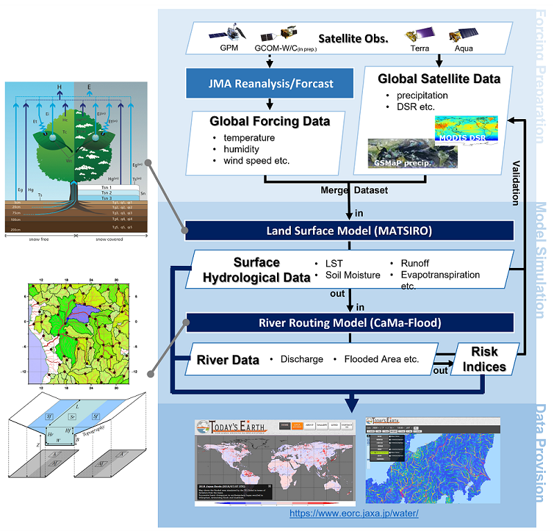
The TE system consists of land surface model MATSIRO (Minimal Advanced Treatments of Surface Interaction and Runoff) and river hydrodynamics model CaMa-Flood (Catchment-based Macro-scale Floodplain).
The system first collects atmospheric information, such as precipitation and air temperature, obtained from various sources including satellite observations, reanalysis datasets, and numerical weather prediction, and prepares these data as input to the system. Based on these input data, MATSIRO calculates the exchanges of water and energy between the atmosphere and the land surface, and outputs various land surface variables, such as soil moisture and evapotranspiration, for each model grid cell.
Among these output variables, runoff, which represents the amount of water flowing laterally out of each grid cell, is passed to CaMa-Flood. CaMa-Flood then calculates river water depth and flow velocity on a global scale. The system also simulates how water spreads over the surrounding topography as a result of changes in calculated water depth, and outputs data related to floodplain inundation.
All data calculated and output by the TE system are available for download in netCDF format after user registration through the DATA ACCESS page. Major variables can also be viewed in real time without registration on the monitoring pages accessible from the top page.
The monitoring pages not only visualize physical variables, but also display indicators such as anomalies from climatological conditions and return periods, which indicate the approximate rarity of an event. These indicators allow users to quickly understand the severity and potential impact of ongoing phenomena, and to identify when and where extreme events are occurring even without specialized knowledge.
Introduction Video
Available in Japanese only (please use YouTube’s automatic translation feature)
Publications and References
When using Today’s Earth products, please cite the following paper(s) corresponding to each product.
TE-Global
- Ma, W. et al. A new generation of hydrological condition simulator employing physical models and satellite-based meteorological data. Earth and Space Science 11, (2024). https://doi.org/10.1029/2023EA003228
TE-Global NEXRA
- Yamamoto, K. et al. Development and validation of a global ensemble hydrological simulation system: TE-Global NEXRA. Hydrological Research Letters 19, 80–86 (2025). https://doi.org/10.3178/hrl.24-00022
TE-Japan
- Ma, W. et al. Applicability of a nationwide flood forecasting system for Typhoon Hagibis 2019. Scientific Reports 11, 10213 (2021). https://doi.org/10.1038/s41598-021-89522-8
- Yoshimura, K. et al. Toward flood risk prediction: a statistical approach using a 29-year river discharge simulation over Japan. Hydrological Research Letters 2, 22–26 (2008). https://doi.org/10.3178/hrl.2.22
For other major references related to the simulation models and atmospheric forcing datasets used in Today’s Earth, please refer to the following papers.
MATSIRO
- Takata, K. et al. Development of the minimal advanced treatments of surface interaction and runoff. Global and Planetary Change 38, 209–222 (2003). https://doi.org/10.1016/S0921-8181(03)00030-4
- Nitta, T. et al. Representing variability in subgrid snow cover and snow depth in a global land model: Offline validation. Journal of Climate 27, 3318–3330 (2014). https://doi.org/10.1175/JCLI-D-13-00310.1
CaMa-Flood
- Yamazaki, D. et al. A physically based description of floodplain inundation dynamics in a global river routing model. Water Resources Research 47, (2011). https://doi.org/10.1029/2010WR009726
- Yamazaki, D. Advancing global river hydrodynamics simulations by catchment-based macro-scale floodplain modeling approach. Geoscience Letters 12, 72 (2025). https://doi.org/10.1186/s40562-025-00452-z
Atmospheric forcing datasets
- Kobayashi, S. et al. The JRA-55 Reanalysis: General specifications and basic characteristics. Journal of the Meteorological Society of Japan. Ser. II 93, 5–48 (2015). https://doi.org/10.2151/jmsj.2015-001
- Kubota, T. et al. Global precipitation map using satellite-borne microwave radiometers by the GSMaP project: Production and validation. IEEE Transactions on Geoscience and Remote Sensing 45, 2259–2275 (2007). https://doi.org/10.1109/TGRS.2007.895337
- Kotsuki, S. et al. Assimilating the global satellite mapping of precipitation data with the Nonhydrostatic Icosahedral Atmospheric Model (NICAM). Journal of Geophysical Research: Atmospheres 122, 631–650 (2017). https://doi.org/10.1002/2016JD025355
- Yin, G. et al. A support vector machine-based method for improving real-time hourly precipitation forecast in Japan. Journal of Hydrology 612, 128125 (2022). https://doi.org/10.1016/j.jhydrol.2022.128125