Seen from Space 2011
The Curonian Spit on the Baltic Sea
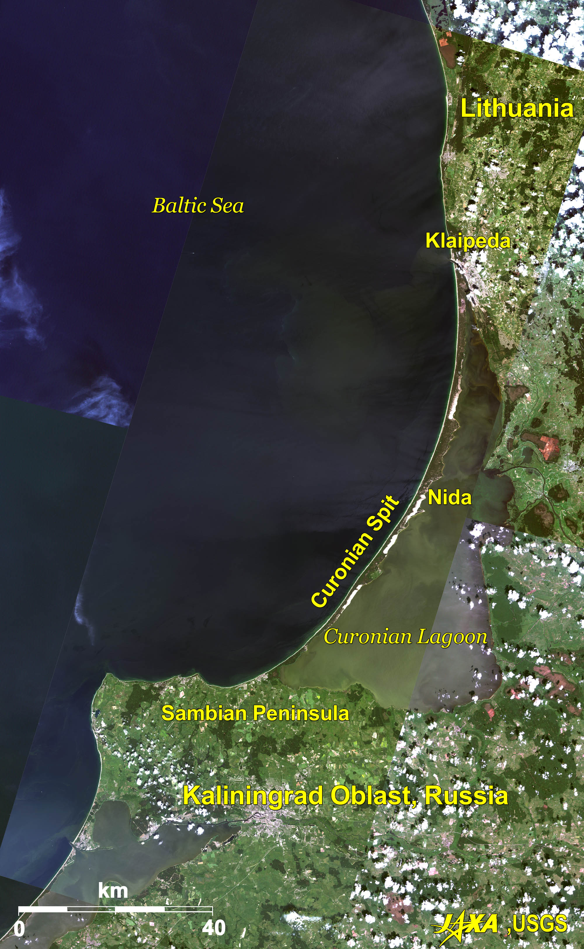  Fig. 1. Curonian Spit and Its Surroundings
Figure 1 is a composite image of the Curonian Spit and its surroundings taken by Landsat in 2002 and ALOS (Daichi) in 2007. The Curonian Spit, a 100-km-long sand dune separating the Baltic Sea from the Curonian Lagoon, stretches from the Sambian Peninsula of Kaliningrad Oblast, Russia, in the south to Klaipeda, Lithuania, in the north. The width of the spit varies from of its narrowest at 400 m near the Sambian Peninsula to its widest at 3,800 m near Nida in the middle of the spit. Amanohashidate, one of Japan’s Three Scenic Views, is around 4 km long and 20 m-170 m wide. That makes the Curonian Spit twenty times larger than Amanohashidate. The spit has been registered to Cultural Landscape of UNESCO World Heritage. 
The Curonian Spit CrisisDeforestation of the spit due to timber harvesting for housing and fuel in the sixteenth and seventeenth centuries led to the spit becoming a naked dune. Erosion by the wind and sea current from the Baltic Sea threatened the disappearance of the spit. Alarmed by this crisis, reforestation activities started and most areas of the spit are now covered with forest. 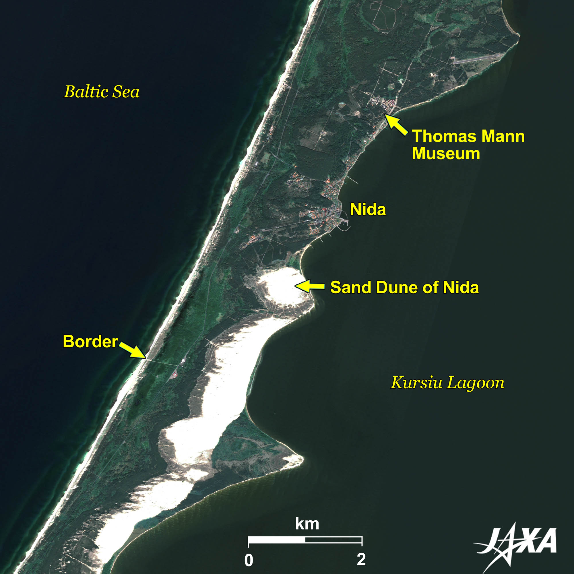  Fig. 2. Nida and Its Surroundings
Nida (kmz, 2.77 MB, Low Resolution) as seen on Google Earth. Figure 2 shows the middle of the spit. You can see the line marking the border between Lithuania and Russia. Nida, located near the border, is the largest city in the spit. The contrast between green trees and white sand is impressive. The largest sand dune can be seen in the south of Nida. Thomas Mann, a German novelist, called it “Sahara in the north.” The dune is 60 m high and it moves. Due to this movement, the village of Nida was once buried. For much of the thirteenth and fourteenth centuries, the Curonian Spit was German territory, and as such it has attracted many German tourists. Thomas Mann was one of such visitors and had a villa there. The villa, where Thomas Mann spent two summers from 1930, is now the Thomas Mann Museum.   Fig. 3. Klaipeda and Its Surroundings
Klaipeda (kmz, 3.91 MB, Low Resolution) as seen on Google Earth. Figure 3 shows Klaipeda, the third largest city in Lithuania, and its surroundings. It is located on the narrow channel that connects the Curonian Lagoon to the Baltic Sea. You can see the old town south of Danes River, which flows through the center of the city. As is evident by the warehouses and shipyards in the lower part of the image, Klaipeda is a city of marine transportation. On the opposite bank of Klaipeda are the Curonian Spit and the Marine Museum at Smiltyne, a renovated fortress constructed in the late nineteenth century.
Kaliningrad Oblast, RussiaThe Curonian Spit reaches into Kaliningrad Oblast, Russia, in the south. The oblast is 15,000 square kilometers. It was an exclave of Germany until the end of the First World War, when it became a republic of the Soviet Union. However, in 1991, Lithuania became independent and once again the oblast was an exclave—this time of Russia. The southeastern coast of the Baltic Sea, centered at Kaliningrad Oblast, produces more than 90 percent of the amber in the world. As a result, the area is called the land of amber.
End of operation of ALOS (Daichi)Operation of ALOS (Daichi) ended at 01:50 am (UTC) on May 12, 2011. ALOS was launched on January 24, 2006. ALOS operated beyond the three years of design life and five years of target life. ALOS achieved many useful results of Earth observation. ALOS accumulated 6.5 million scenes of worldwide coverage during the five years and contributed to emergency disaster observation. ALOS took over 400 scenes of the Great East Japan Earthquake (March 11, 2011) and its imageries were provided to ten governmental agencies. Archived imagery taken by ALOS will be used in the REDD+ project. Explanation of the Images:
The image data of Figure 1 is downloaded free of charge from the USGS Global Visualization Viewer (Glovis). The color composite images are produced by assigning red to Band 3 (630 to 690 nm), green to Band 2 (520 to 600 nm), and blue to Band 1 (450 to 520 nm). The resulting images have natural coloring as if seen by the naked eye.
AVNIR-2 has four observation bands. The color composite images are produced by assigning red to Band 3 (610 to 690 nm), green to Band 2 (520 to 600 nm), and blue to Band 1 (420 to 500 nm). The resulting images have natural coloring as if seen by the naked eye. Each color indicates the following ground objects:
(Fig. 2) |