ページの先頭です。
本文へジャンプする。
【Important Notices】This page is an archive page of information published in the past. Since the update has been completed, it may contain broken links or outdated information. For the latest information, please use the new site Earth-graphy (earth.jaxa.jp).
ここからサイト内共通メニューです。
サイト内共通メニューを読み飛ばす。
サイト内共通メニューここまで。
ここから本文です。

Seen from Space 2011

Réunion: A Volcanic Island in the Indian Ocean

 
Full View of Réunion Island
  • caption on
  • caption off
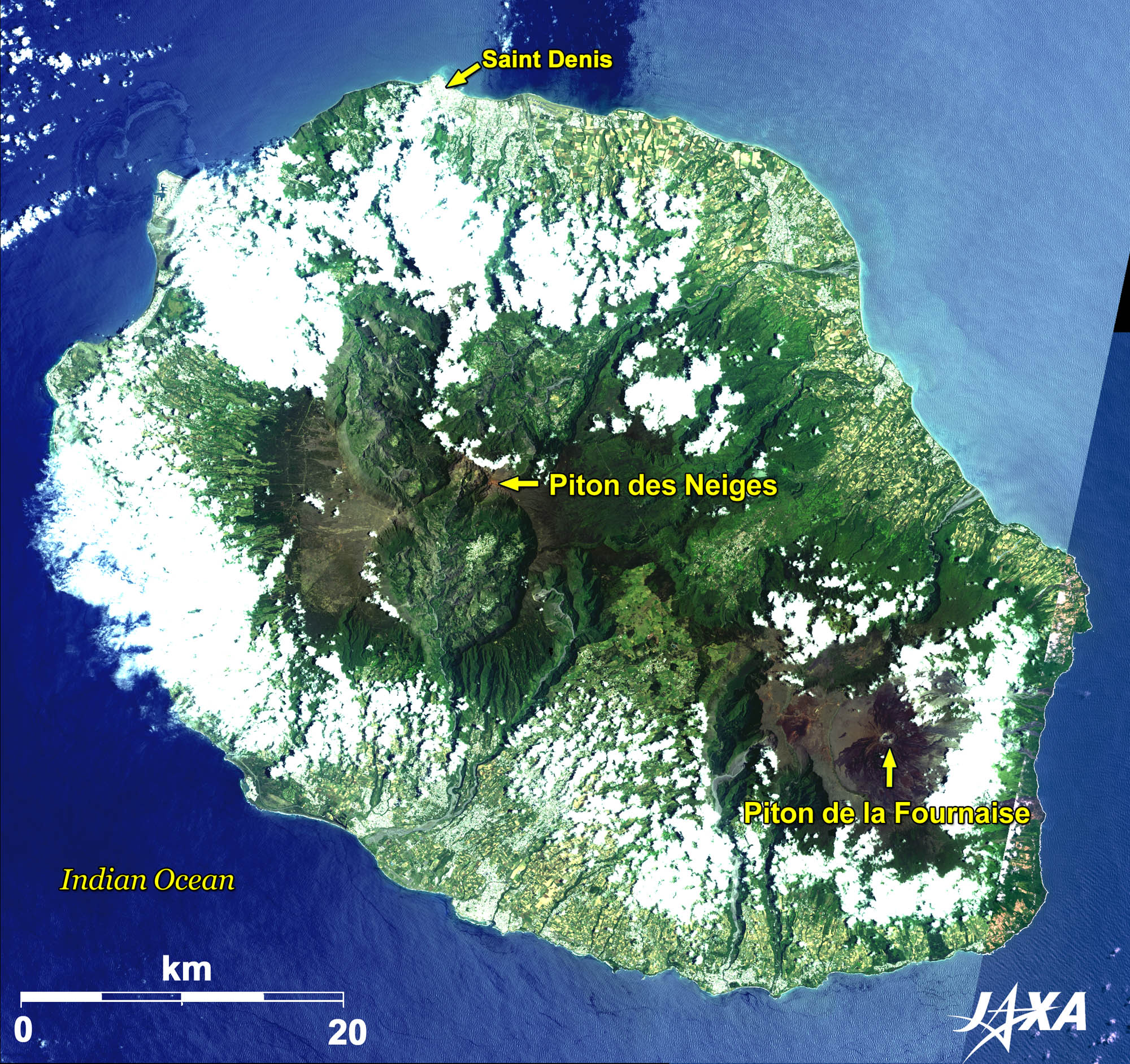
Fig. 1. Full View of Réunion Island

Figure 1 shows a full image of Réunion Island in the Indian Ocean, located 700 km east of Madagascar, as observed by ALOS (“Daichi”) in December 2009 (the easternmost edge of the island was observed in October). Like the Hawaiian Islands, Réunion and Mauritius, located 200 km further east, are both volcanic islands born on hotspot in the ocean bed where magma rose as the result of tectonic movements.
Réunion consists of central and southeastern massifs. The highest peak of the central massif is Piton des Neiges (Snow Peak: 3,069 m) although it is dormant. Three massive calderas (crater valleys) were formed around this peak. Piton de la Fournaise (Furnace Peak: 2,631 m, locally called Le Volcan (The Volcano)) in the southeastern massif is very active and is being watched closely throughout the year. Since the lava is fluid and flows into the ocean like Kīlauea in Hawaii, there is little harm to lives.
The total area of the island is 2,512 km2 and the population is about 820,000. Most of the people live in the surrounding coastal zones. The prefectural capital, Saint-Denis, is located at the island’s northernmost point.
Ethnic groups present on the island include people of European, African, Malagasy, Indian, and Chinese origin, as well as many of mixed races.
Réunion island was first known of by Arabs and Tamil of southern India. The Portuguese were the first European visitors at the beginning of the sixteenth century. French people landed later and declared it a French territory. The island was an important port of call on the way to India for a long time until the Suez Canal opened in 1869. French is the only official language of Réunion, but Réunion Creole, which derived from French, is also spoken.
The geographical features, isolated high peaks in the ocean and the tropical monsoon climate, bring occasional heavy territorial rain to this island. Precipitation of 1,870 mm per day was recorded in March 1952, which is the world record within 24 hours to date. Sugarcane cultivation and sugar production are the main industries of the island. In recent years, the beautiful beaches stretching along the west coast to the south coast attract many tourists.

The outstanding natural landscape of Réunion was registered to the World Heritage Site of UNESCO in 2010 as “Pitons, cirques and remparts of Réunion Island.”

Enlarged Image of Calderas Surrounding Piton des Neiges
  • caption on
  • caption off
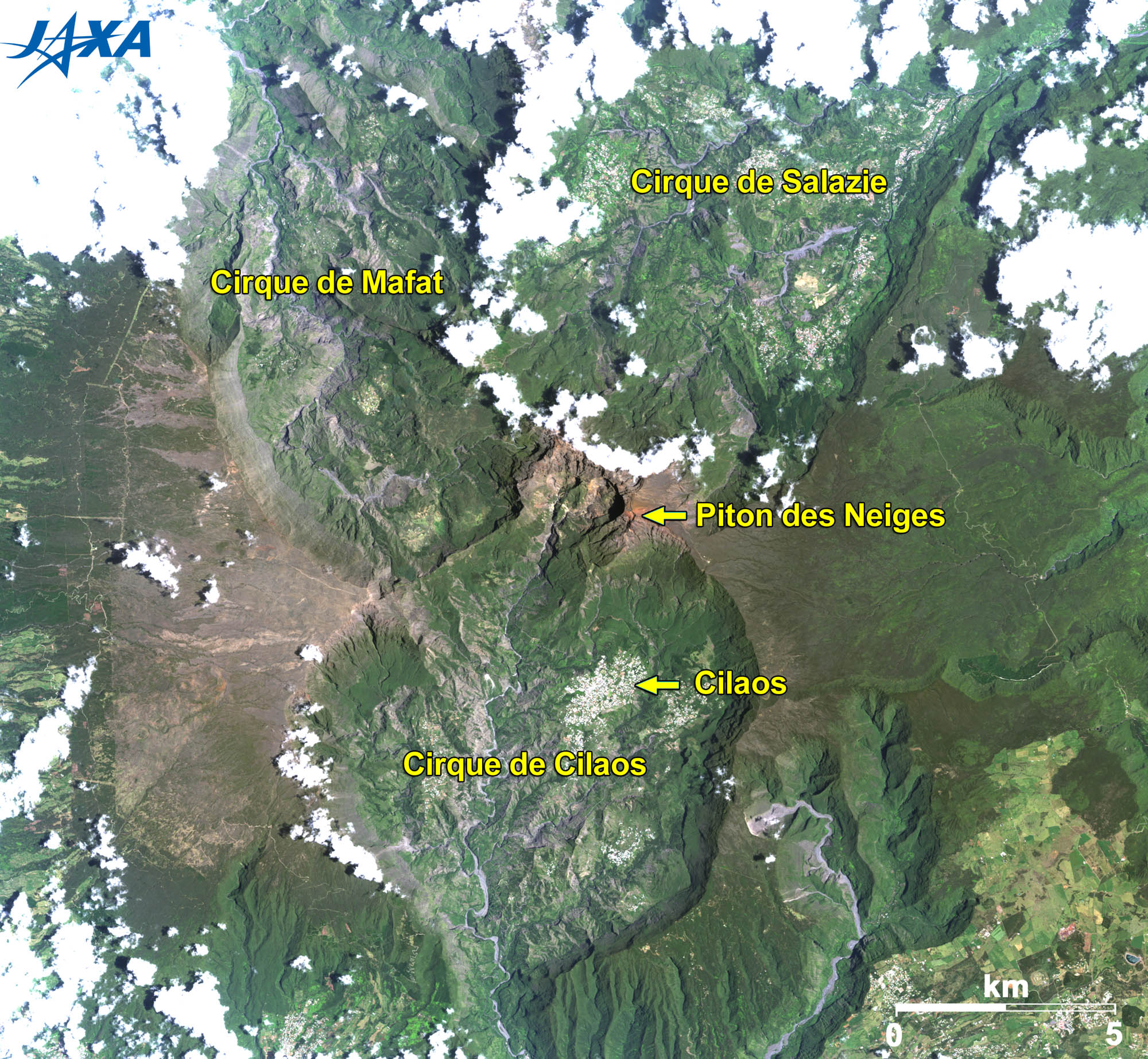
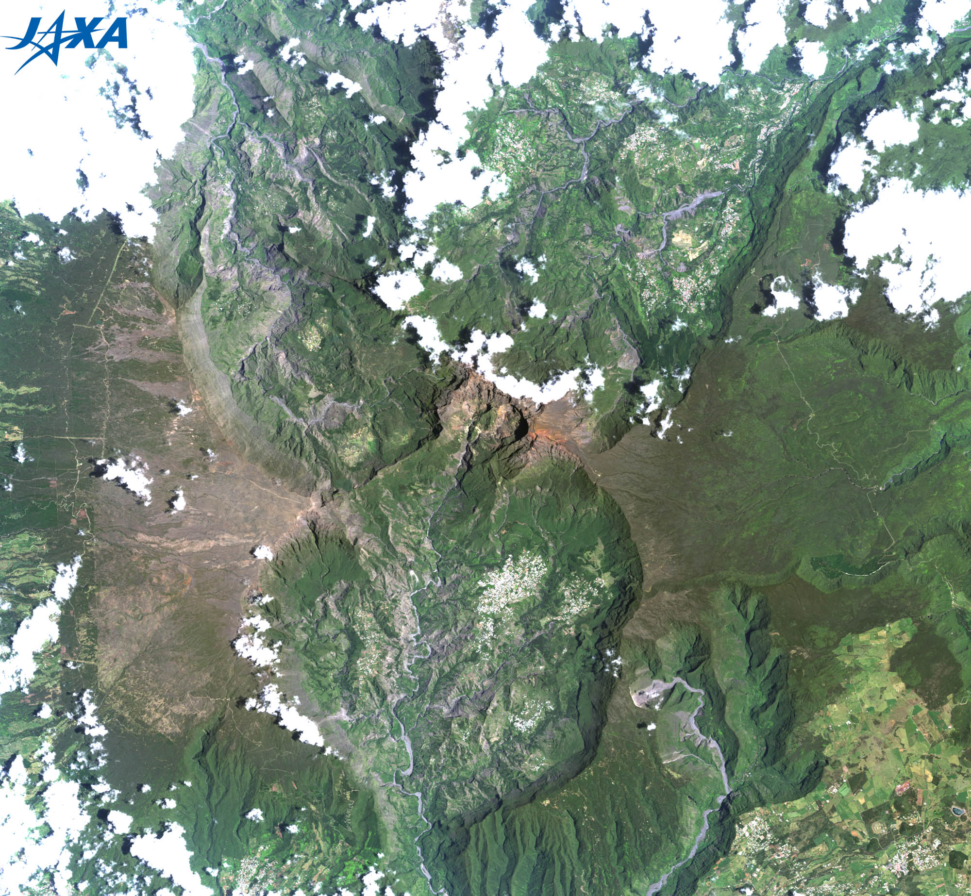
Fig. 2. Enlarged Image of Calderas Surrounding Piton des Neiges
Piton des Neiges (kmz, 3.88 MB, Low Resolution) as seen on Google Earth.

Figure 2 is an enlarged image of the three large calderas (Cirque de Mafate, Cirque de Cilaos, and Cirque de Salazie) surrounding Piton des Neiges.
Helicopter cruising is the only way to enjoy the scenery of Cirque de Mafate. The many iron- and carbonic acid-rich spas at Cirque de Cilaos and the many waterfalls at Cirque de Salazie are major tourist spots. Cirque de Cilaos is mostly developed and the white patch visible in the valley is the town of Cilaos.

Enlarged Image of Piton de la Fournaise
  • caption on
  • caption off
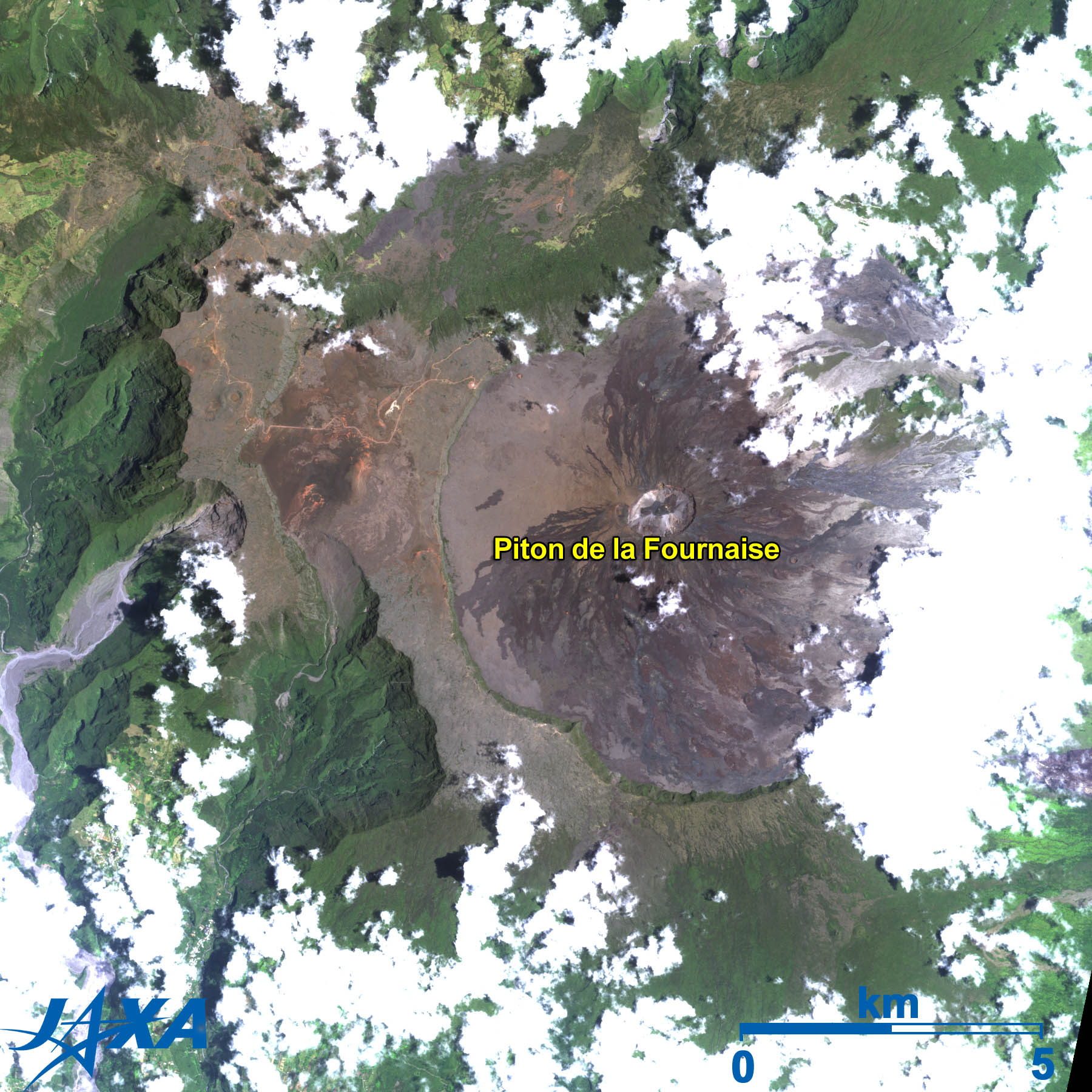
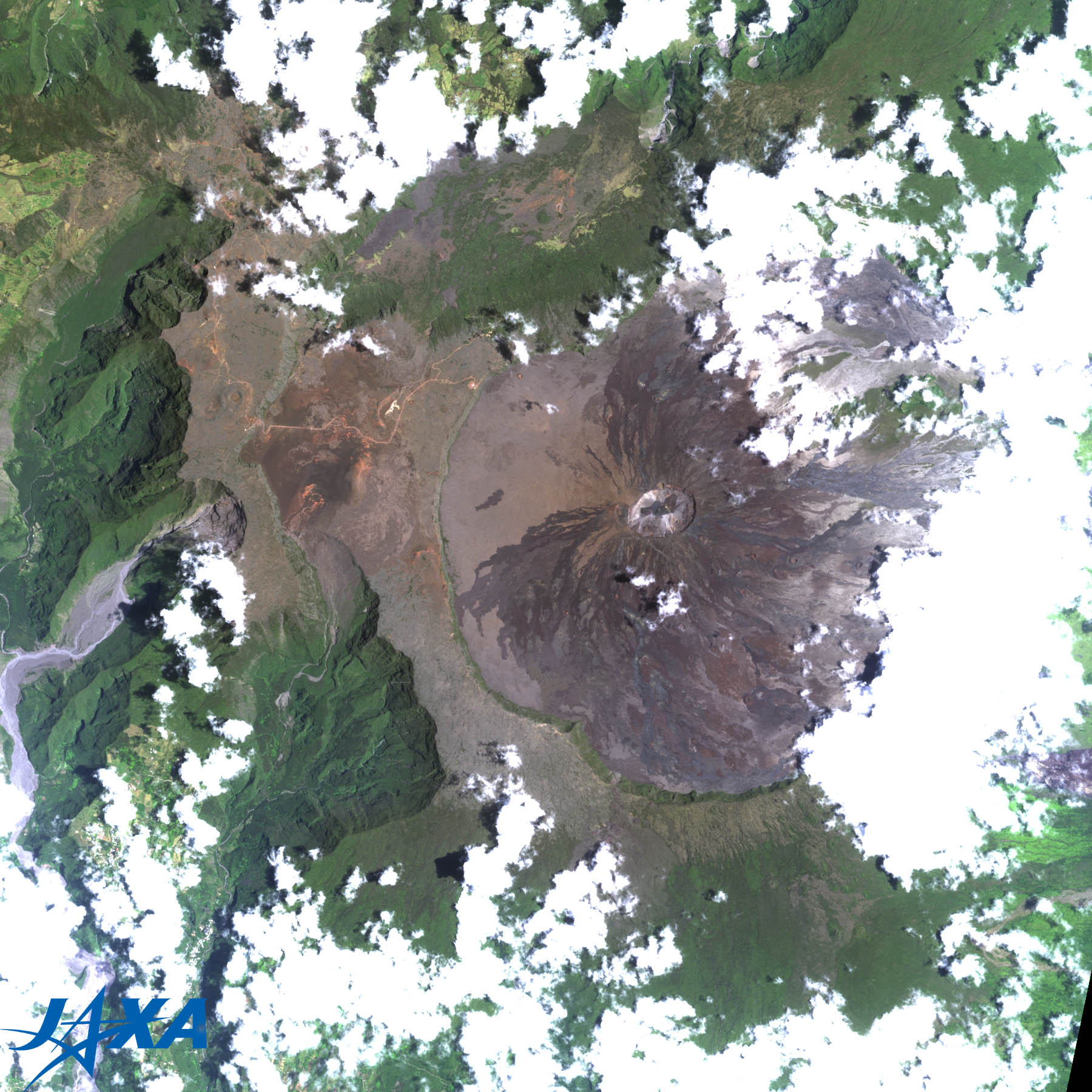
Fig. 3. Enlarged Image of Piton de la Fournaise
Piton de la Fournaise (kmz, 3.41 MB, Low Resolution) as seen on Google Earth.

Figure 3 in an enlarged image of Piton de la Fournaise, which is currently in a period of frequent volcanic activity. The whole summit area is covered by lava and looks grey or dark brown without any sign of vegetation. The most recent eruption occurred on October 14, 2010, and many tourists visited to watch the lava flow closely.

Newly Registered World Heritages in 2010

In August 2010, UNESCO announced on the Web seventeen newly registered World Heritage sites and later added six more sites. One of which is Réunion, whose unique landscape and valuable ecosystem were recognized. There are a total of 911 World Heritage sites to date - 35 of which belong to France.


Reference Sites:

Explanation of the Images:


Satellite: Advanced Land Observing Satellite (ALOS) (Daichi)
Sensor: Advanced Visible and Near Infrared Radiometer-2 (AVNIR-2)
Date: 0637 (UTC) on December 14, 2009 (Fig. 1 - 3)
0635 (UTC) on October 12, 2009 (Fig. 1)
Ground resolution:

10 m

Map Projection: Universal Transversal Mercator (UTM)

AVNIR-2 has four observation bands. The color composite images are produced by assigning red to Band 3 (610 to 690 nm), green to Band 2 (520 to 600 nm), and blue to Band 1 (420 to 500 nm). The resulting images have natural coloring as if seen by the naked eye. Each color indicates the following ground objects:

Dark green: Forests
Light green: Grass fields or farmland
Brown: Bare land
White: Buildings, roads, or clouds
Blue: Sea surface
本文ここまで。
image:Satellite Navigator
image:Satellite Applications and Operations Center(SAOC)
Earth Data Collection by JAXA Satellites
image:ページTOP