Seen from Space 2010
Sado: The Island that Prospered from Gold and Silver Mining
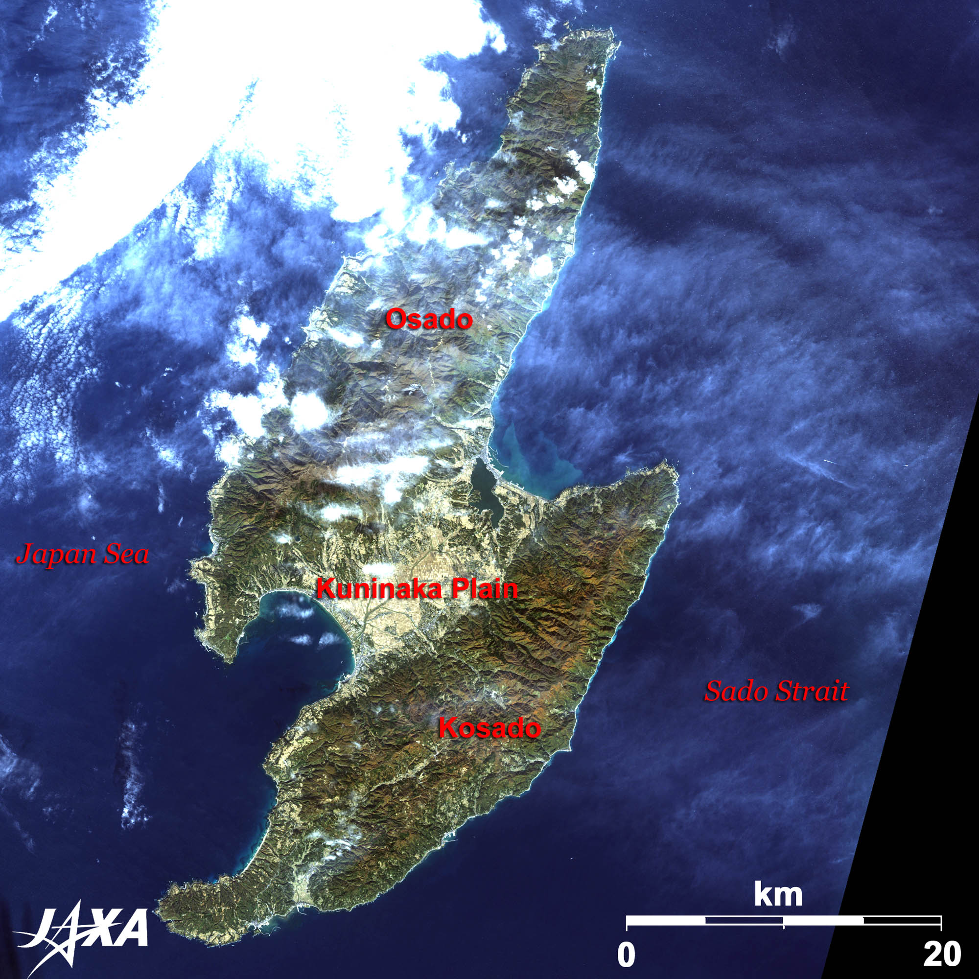 
Fig. 1. The Island of Sado
Figure 1 is an image of Sado Island taken by ALOS (Daichi) in November 2009. Getting to Sado Port takes about two and a half hours by car ferry or one hour by high-speed craft (Jetfoil) from Niigata Port. The island has a total area of 855 square kilometers. Sado is home to the Kuninaka Plain in the middle of the island, Osado (Big Sado) in the north, and Kosado (Small Sado) in the south. The Osado Mountains run through Osado. Cliffs and strangely shaped rocks cut by the rough ocean current create marvelous natural scenery. On the contrary, the mountains in Kosado are gently-sloping hills and beautiful beaches line the coasts. Many visitors stay there and enjoy sea bathing in the summer as if they were at resorts in the south. 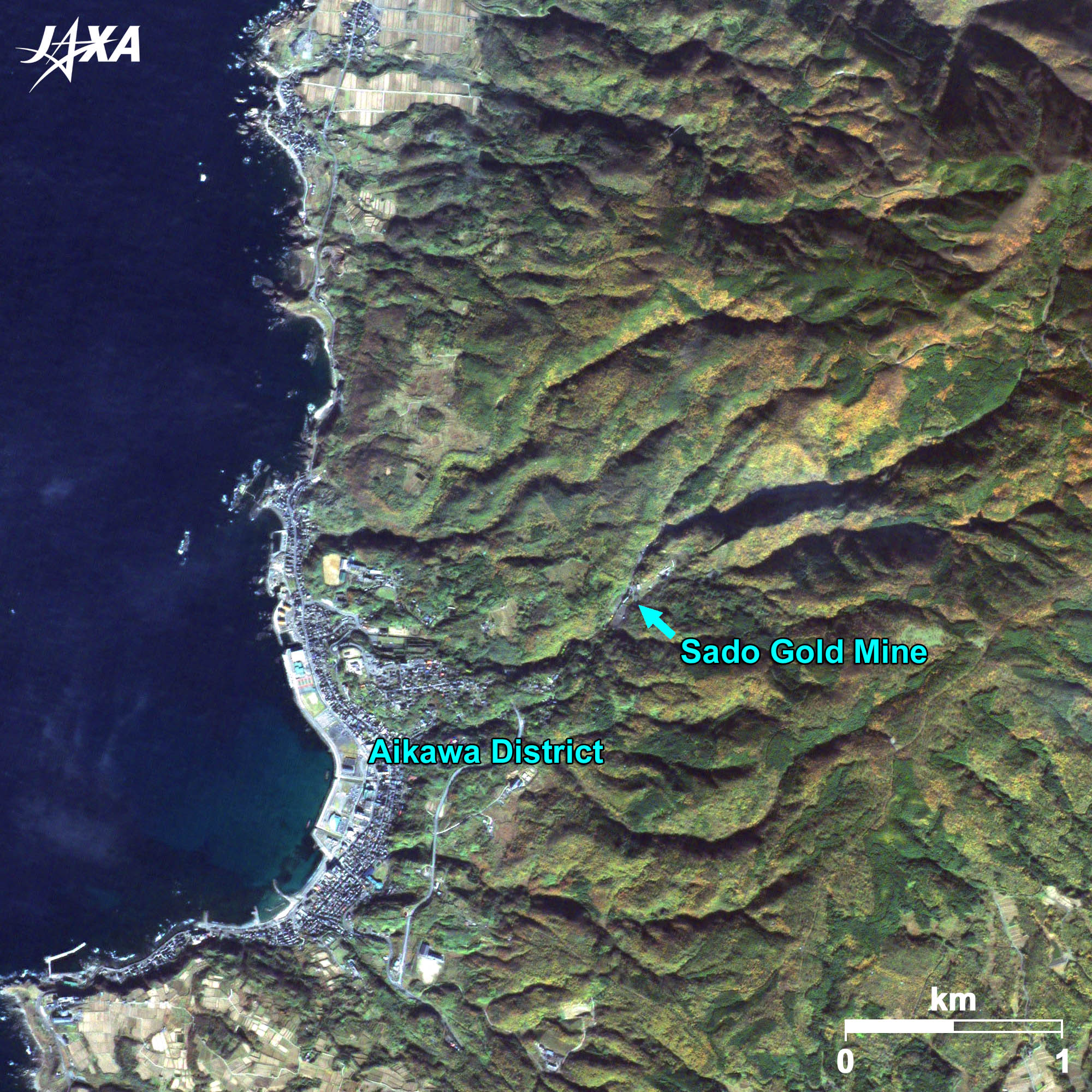 
Fig. 2. Enlarged Image of the Aikawa District
Aikawa (kmz, 5.01 MB, High Resolution) as seen on Google Earth 
History of the Island, the Place of Exile and Gold MinesSado was one of the farthest places of exile in the Nara era (eighth century). People who were banished to Sado include the retired emperor Juntoku who attempted a coup (1221), monk Nichiren who criticized the Kamakura Shogunate (1271), and Noh playwright Zeami (1431) who established the Noh Theater in the Muromachi era. These men played a role in disseminating advanced culture. For example, because of Zeami’s efforts, Noh culture has been popular on the island and there remain more than 30 Noh stages. Sado is also world famous for its history of gold and silver mining. The excavation of gold and silver was stated in literature from the Heian era (from the eighth to twelfth centuries). Tokugawa Ieyasu, founder of the Tokugawa Shogunate, directly governed the island and developed gold and silver mining after the Battle of Sekigahara in 1600. Figure 2 shows the Aikawa district, which prospered from the gold and silver mining. Remains of gold mines are visible at the heart of the mountains. Those mines yielded more than 400 kg of gold and 25 tons of silver at the beginning of the seventeenth century. The gold and silver production supported the financial affairs of the Tokugawa Shogunate. Over 50 thousand mining engineers, merchants, and workers crowded into the Aikawa district, which had been a deserted village until then. Gold and silver mining in Sado became famous around the world. The name SADO or Minas d’Or appeared on maps created in eighteenth century Europe. Gold and silver mining in Sado was developed through the Edo, Meiji, Taisho, and Showa eras, while introducing advanced technologies. However, the yield steadily declined and the mines were closed in March 1989. The total yield from the Tokugawa era to the final year is estimated at around 78 tons of gold and 2,300 tons of silver. The mining tunnels reached around 400 km. The glorious history of Sado mining is now exhibited in a museum.  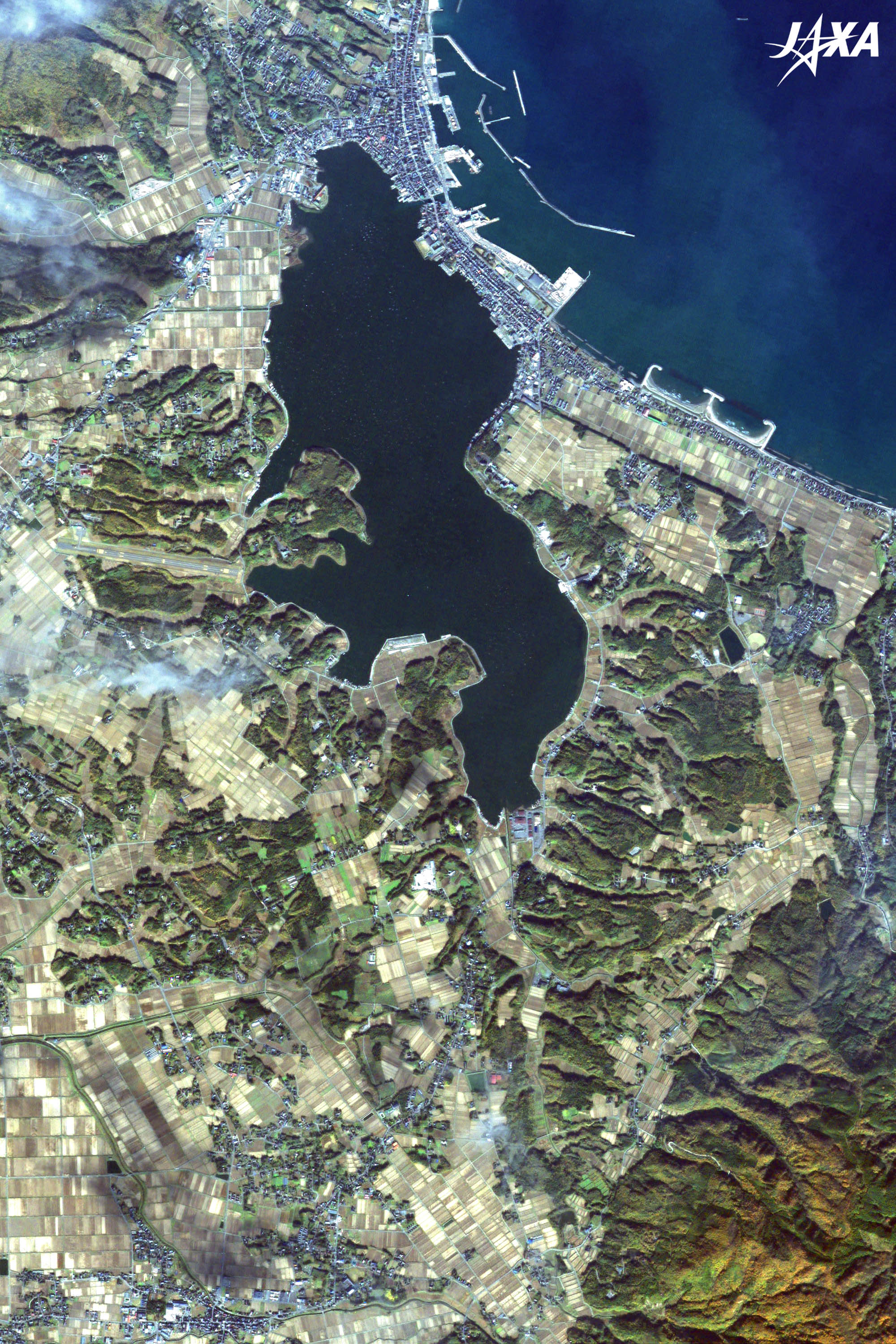
Fig. 3. Enlarged Image of Ryotsu Port and Kamo Lake
Ryotsu Port (kmz, 7.84 MB, High Resolution) as seen on Google Earth Figure 3 shows an enlarged image of Ryotsu Port and Kamo Lake located at the northeast of the Kuninaka Plain. Ryotsu Port is a main gateway to Sado from Niigata Port. Ferries from Niigata Port arrive at Ryotsu Port. Kamo Lake, which became brackish when the lake was connected to Ryotsu Bay in 1904, has seen oyster farming flourish ever since. An airport was constructed on the west side of the lake. However, there is no regular air passenger service now. Some field centers built to protect crested ibis are located around the south of Kamo Lake.
Crested IbisCrested ibis have been seen in many parts of Japan but they have close ties to Sado. Crested ibis lived in Sado only until 1971 when excessive hunting and land development forced them into endangerment. Efforts were made to protect and breed crested ibis, yet unfortunately, Japanese crested ibis became extinct in 2003. The Sado Crested Ibis Conservation Center was given Chinese crested ibis and in August 2010 171 crested ibis were bred and raised there. Crested ibis are trained in the Reinstruction Center how to feed, how to fly long distance, how to recognize natural enemies, and how to escape from enemies. After being trained, crested ibis are released into the wild. It will not take long until we can see wild crested ibis in Japan. Explanation of the Images:(Click the images twice to enlarge.)
AVNIR-2 has four observation bands. The color composite images are produced by assigning red to Band 3 (610 to 690 nm), green to Band 2 (520 to 600 nm), and blue to Band 1 (420 to 500 nm). The resulting images have natural coloring as if seen by the naked eye. Each color indicates the following ground objects:
(Fig. 2 and Fig. 3) The above AVNIR-2 color composite image is decomposed into, hue, saturation, and intensity. The intensity portion is replaced by PRISM data. The hue, saturation, and intensity data are then reversed into a color image. This color image has a virtual 2.5-m resolution. A color image composed by combining a higher resolution monochromatic image and a lower resolution color image is called a pan-sharpened image. |


