Seen from Space 2010
Matsuyama, Japan: Hometown of Meiji Era Heroes
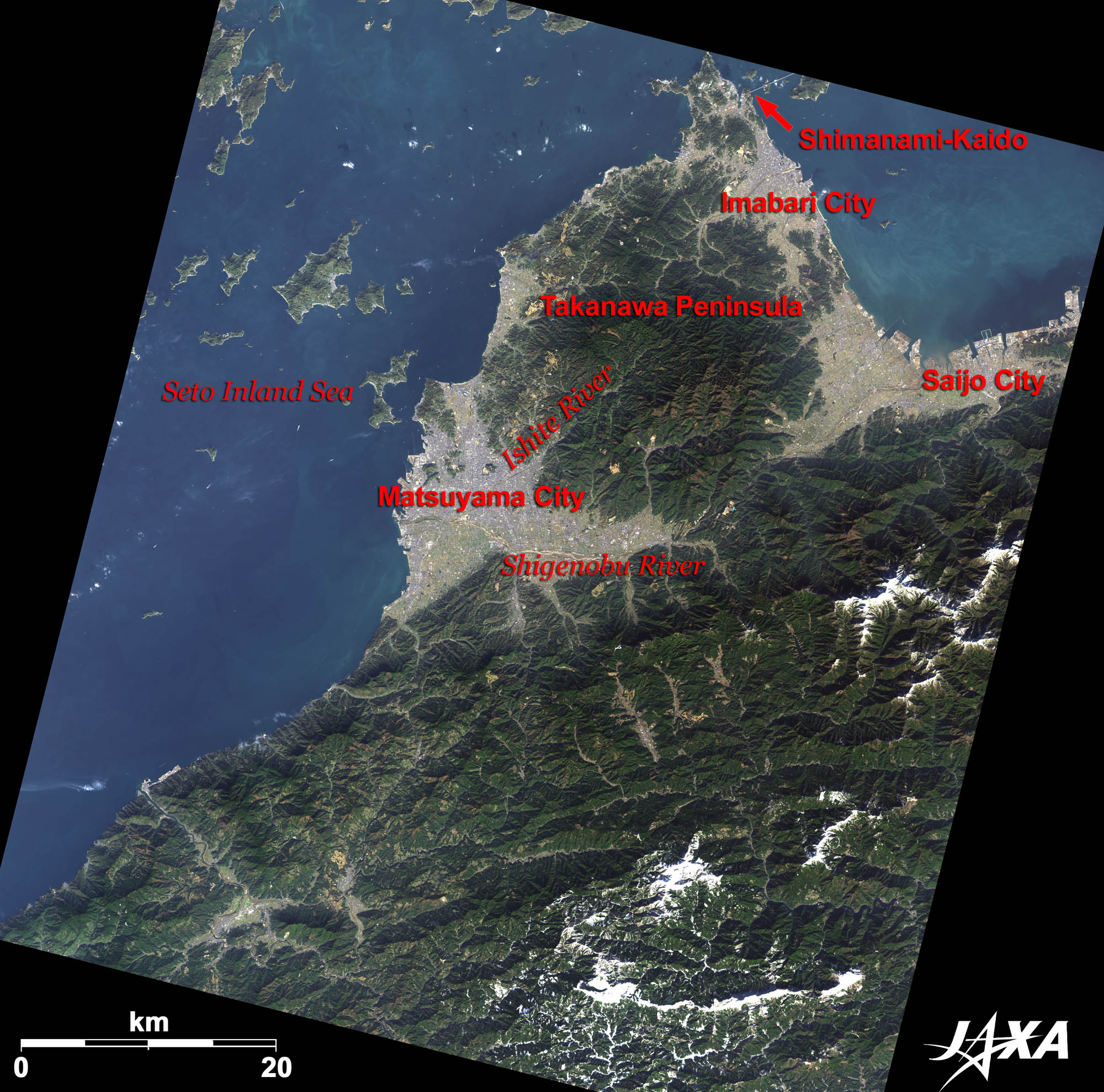  Fig. 1. Matsuyama City and Its Surroundings
Figure 1 is an image of Matsuyama City and its surroundings taken by ALOS (“Daichi”) in December 2009. Matsuyama is located in the Matsuyama Plain, in the middle of the image, and faces the Inland Sea of Japan to the west. Its population is over 500,000, making it the largest city in Shikoku (one of the four main islands of Japan). It is a city of tourism as well as one of industry. 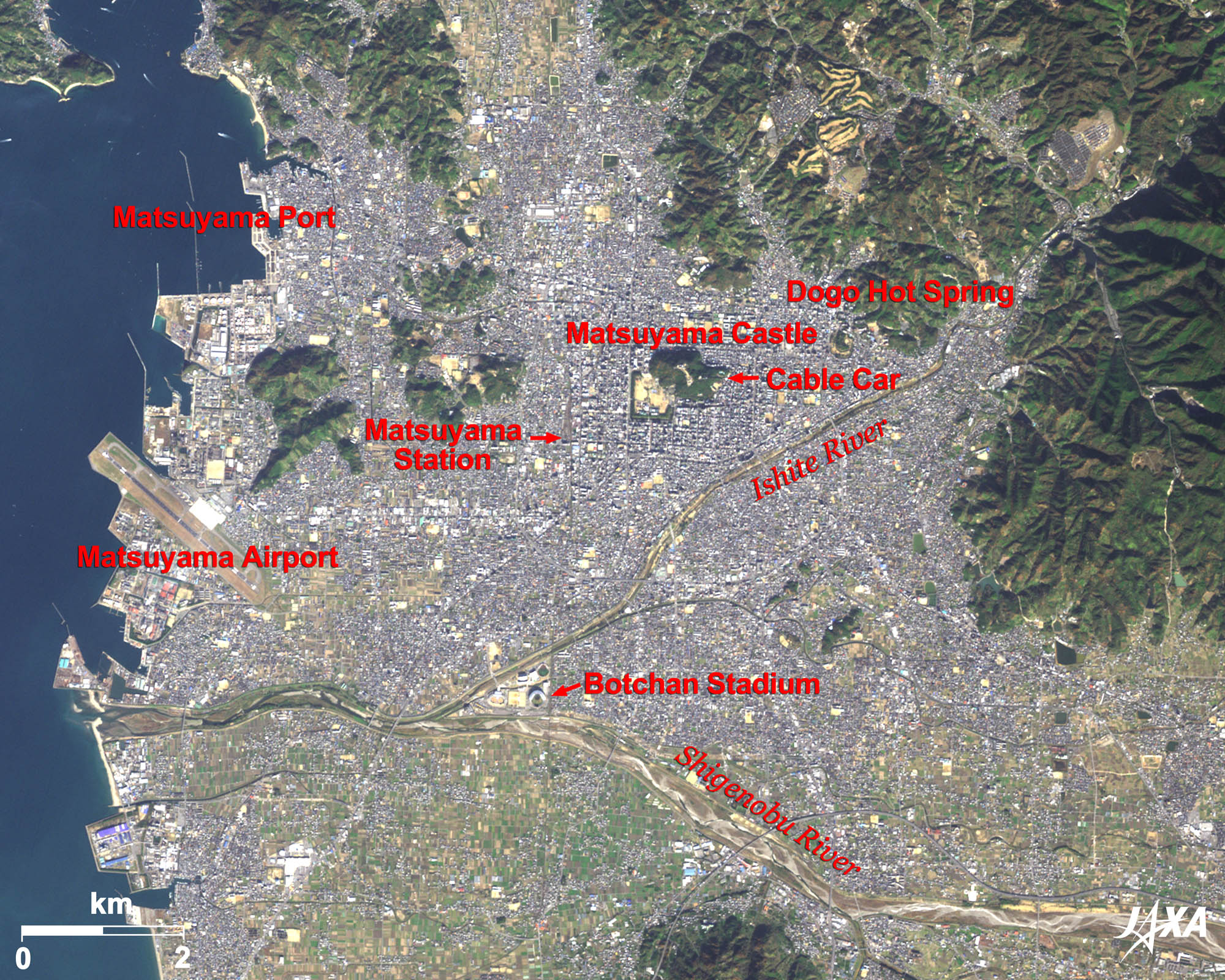 
Fig. 2. Central Matsuyama
Matsuyama City (kmz, 4.55 MB, Low Resolution) as seen on Google Earth The Ishite River, which flows south of Katsuyama, also flooded many times and turned the basin into wetlands. Adachi changed the flow of the Ishite River and joined it to the Shigenobu River, thus preventing floods and developing irrigation. He also cut off the two peaks of Katsuyama and buried the valley to construct the castle. He began construction of the castle in 1602, and named the area Matsuyama. Construction took over 25 years and was almost completed in 1627. Before its completion, Adachi died and Kato was transferred to Aizuwakamatsu. Gamou came next to Matsuyama, followed by Matsudaira. Matsudaira was a feudal lord of the Tokugawa family. During the Edo era, industrial and commercial activities prospered and the city expanded. Matsuyama Castle was struck by lightning and burned in 1784. It was later reconstructed in 1854 and is now the last remaining castle completed in the Edo era. The present castle tower was built at that time. Matsuyama Castle was one of twelve castles constructed before the end of the Edo era that retain original castle towers. Among the castles, Matsuyama Castle is the only one that bears the family crest of the Tokugawa, the triple hollyhock. The hill can be accessed via cable car. The whole area of Katsuyama has been designated as a historic park and selected as one of a hundred spots to view beautiful cherry blossoms in Japan. Many people visit there when the trees are in bloom. 
Dogo Hot Spring and Botchan* (Master Darling)Matsuyama has been designated one of the International Sightseeing, Hot Spring and Cultural Cities by the government. The city has many tourist spots and Dogo Hot Spring is the most famous site among them. It is said to be the oldest hot spring in Japan, visited by emperors and Prine Shotoku in the sixth and seventh centuries. In the novel “Botchan” (meaning “Young Master”) written by famous novelist Soseki Natsume in 1906, Botchan visited Dogo Hot Spring by train. A restored train now operates in the city. The stage of the novel is Matsuyama and the novel is so popular in Matsuyama that the baseball field at Matsuyama Central Park was nicknamed Botchan Stadium. * Botchan is considered one of the most popular novels in Japan. It is a story of the struggle of an innocent, daring, and highly-conscientious young teacher who moved to Matsuyama from Tokyo. 

Fig. 3. Enlarged Image of Central Matsuyama
Figure 3 is an enlarged image of central Matsuyama. Matsuyama Castle, a symbol of Matsuyama, is visible in the center of the image. The castle is surrounded by residential areas.
Hometown of Meiji Era HeroesRyotaro Shiba wrote the novel Clouds over the Slope. He described the Meiji era as the period when Japan had developed forward into modernization. Three people, the Akiyama brothers (Yoshifuru and Saneyuki) and Shiki Masaoka are the main characters in the novel. They were born and grew up in Matsuyama. Images of ALOS (Daichi) are used on the “goo maps” web page (NTT Resonant Group). You see satellite images when you click on the “aerial” button at the upper-left of the map. The background image then changes to a satellite image. Explanation of the Images:
AVNIR-2 has four observation bands. The color composite images of Fig. 1 and Fig. 2 are produced by assigning red to Band 3 (610 to 690 nm), green to Band 2 (520 to 600 nm) and blue to Band 1 (420 to 500 nm). The resulting images have natural coloring as if seen by the naked eye. In the above figures, green is assigned to the sum of 95 percent of Band 2 and 5 percent of Band 4 (760 to 890 nm), which improves the visibility of vegetation. Thus, the following colors designate ground objects:
PRISM is an optical sensor for observing ground surfaces with visible and near-infrared signals in the 520- to 770-nanometer (one-billionth of a meter) band. The image is monochromatic but has a higher resolution. PRISM has three independent optical systems to acquire images in the view of nadir, forward, and backward simultaneously. Only the nadir images are used in these figures. The above AVNIR-2 color composite image is decomposed into, hue, saturation, and intensity. The intensity portion is replaced by PRISM data. The hue, saturation, and intensity data are then reversed into a color image. This color image has a virtual 2.5-m resolution. A color image composed by combining a higher resolution monochromatic image and a lower resolution color image is called a pan-sharpened image. |


