Seen from Space 2009
Nagasaki and Warship Island The Seaport Town opened to the World in the Edo Era and the Island that supported Industrialization in Japan
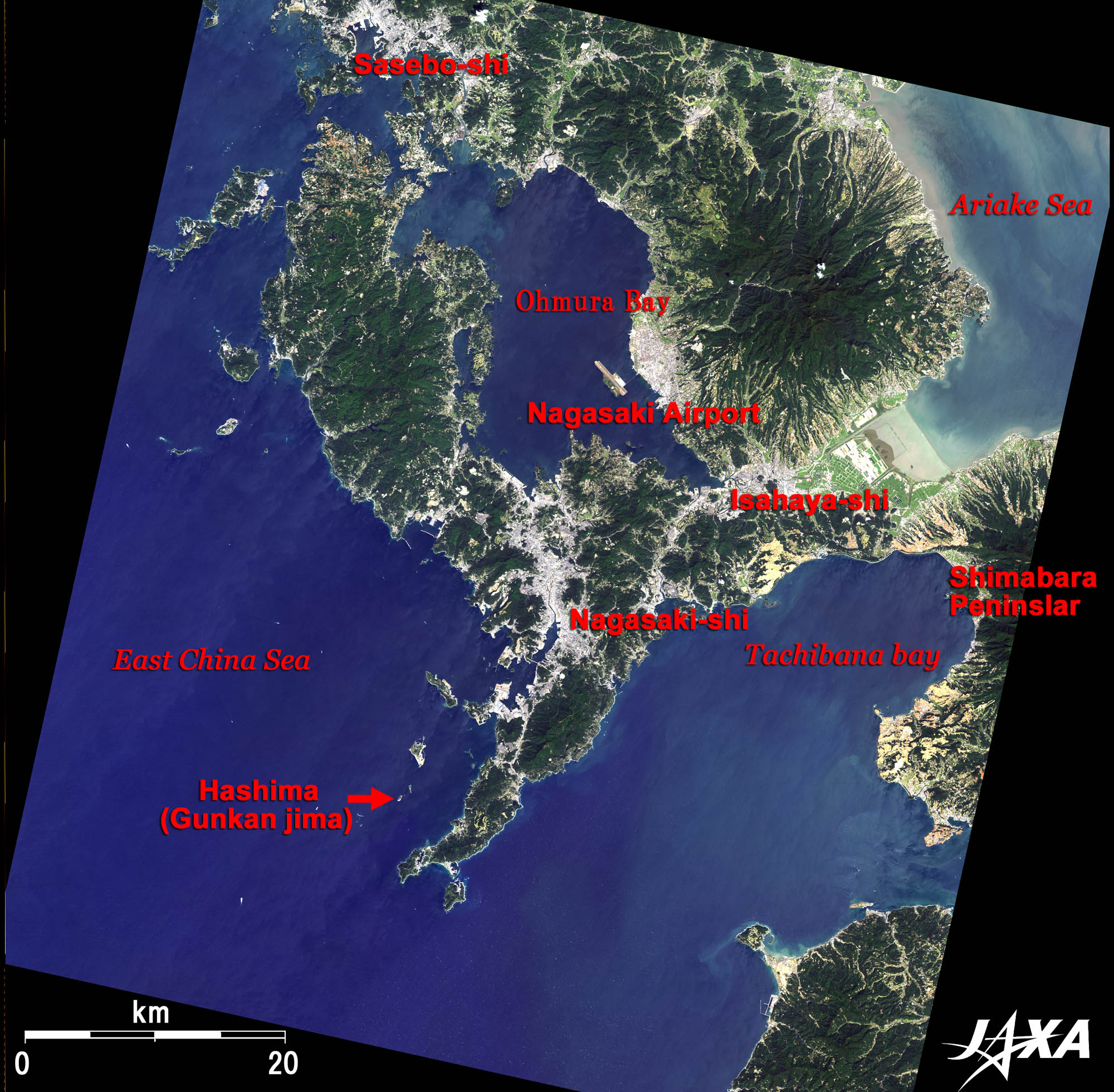  Fig. 1. Nagasaki and Its Surroundings
Figure 1 shows Nagasaki-shi (city) and its surroundings as observed by ALOS (Daichi) in September 2009. Nagasaki is located on the west coast of Kyushu, one of the four main islands of Japan, at the deepest part of Nagasaki Bay, which faces the East China Sea. As you can see from the image, Nagasaki is surrounded by mountains, bays, and inlets. Nagasaki is embedded in a hilly and complex landform, giving it the second longest coastline after Hokkaido. Nagasaki Prefecture is blessed with a natural environment; it has two national parks and two quasi-national parks. The Shimabara Peninsula, seen on the right side of the image, is an active volcano and has many hot springs. Nagasaki Airport is in the middle of the image, in Ohmura bay, in Northern Nagasaki. The Airport was constructed on the sea to provide sufficient land for a runway. Nagasaki has played an important role as a port of diplomacy and trade. For example, Dejima of Nagasaki was the sole port of external trading for more than 200 years during the Tokugawa Shogunate, who decided to close the country in 1633. Nagasaki was atomic bombed after Hiroshima at the end of World War II. Coal industries prospered in the period of reconstruction after World War II, but the mines were closed with the development of the energy revolution. Hashima Island is one such closed coal mine. Hashima is also called Gunkan-jima, meaning Warship Island, and is located southwest of the Nagasaki Peninsula. 
Nagasaki: A Scenic City with Many Up-Down Slopes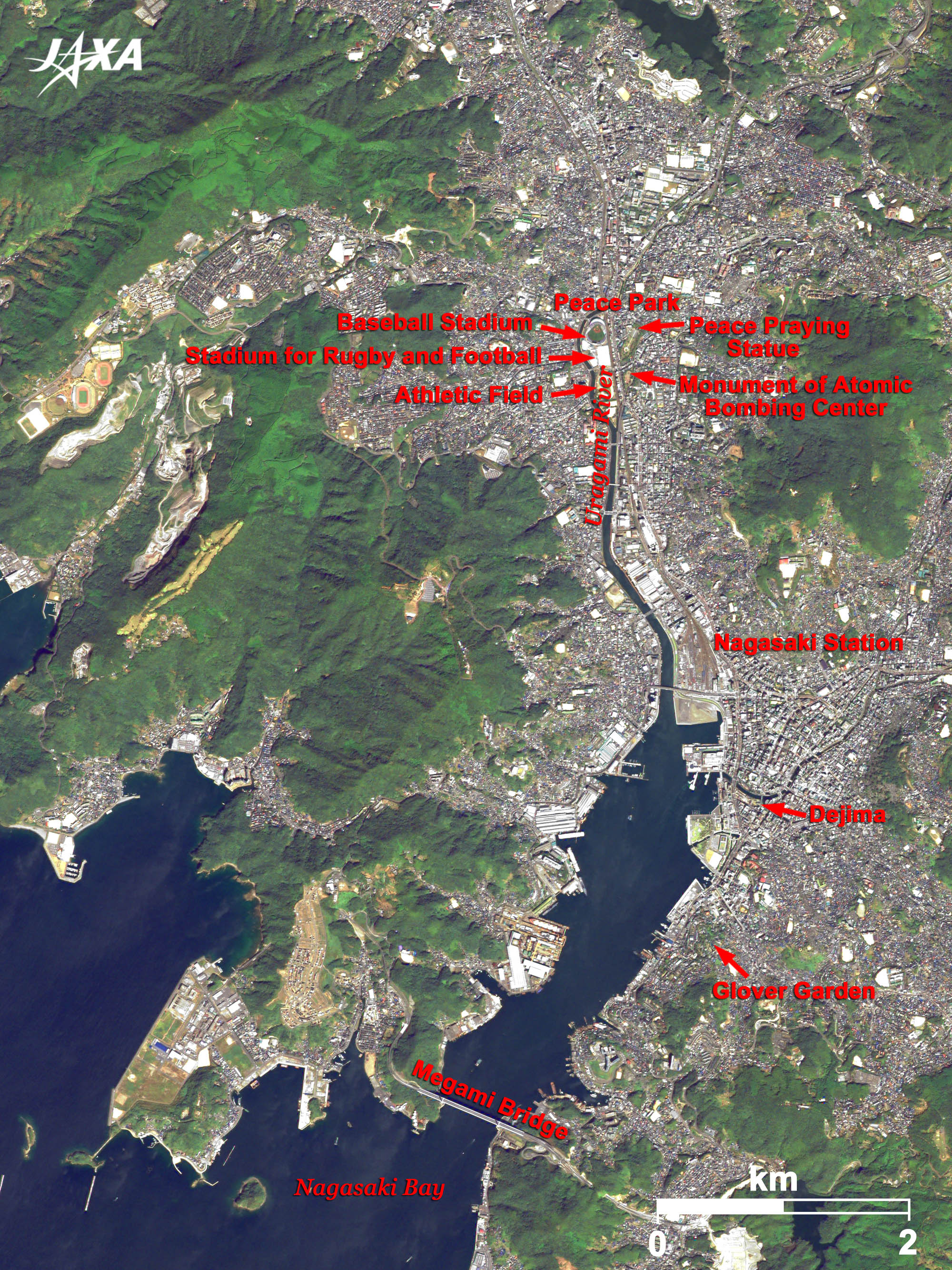  Fig. 2. Enlarged Image of Nagasaki
Nagasaki (kmz, 6.50 MB, Low Resolution) as seen on Google Earth Figure 2 is an enlarged image of Nagasaki. As you can see, Nagasaki has developed along the Uragami River and is surrounded by mountains. The Peace Park, a memorial for world peace and cultural exchange, is located in the upper part of the image along the Uragami River. The Peace-praying Statue and the monument of the Atomic Bombing Center stand in the eastern area of the park. To the west, there are a baseball stadium, a stadium for rugby and football, and an athletic field. The middle of the image is a central part of Nagasaki, located at the mouth of the Uragami River, where you can find Nagasaki Station and the Dejima Museum. The southern hill is where foreign people first settled when the country was opened to foreign trade. A western style house remains in the Glover Garden. Megami Bridge crosses the inlet and connects the south and west of Nagasaki. 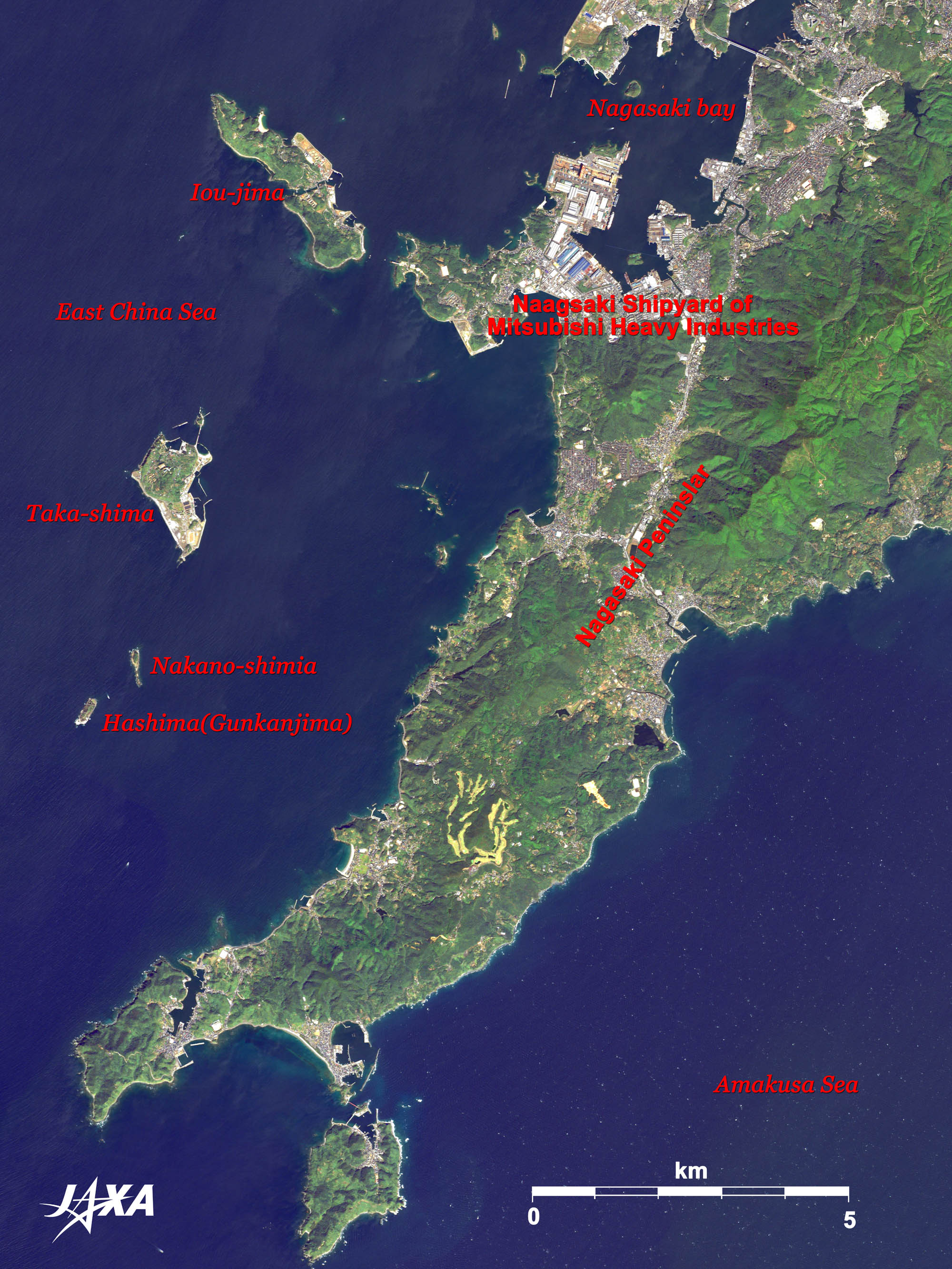 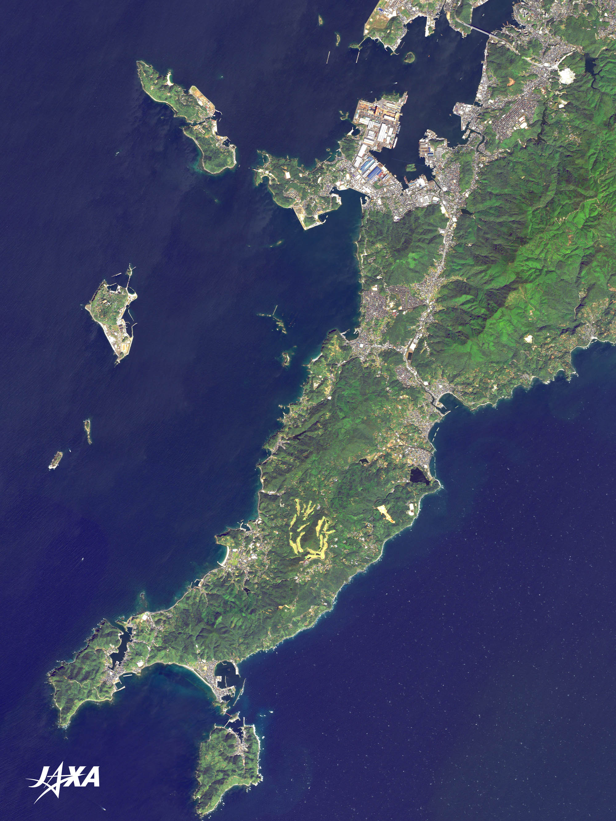 Fig. 3. Hashima (Warship Island) and the Nagasaki Peninsula
Figure 3 shows Hashima (Warship Island) and the Nagasaki Peninsula. The large island near the Peninsula is Iou-jima and the islands in the lower left are Taka-shima, Nakano-shima and Hashima. You can see the Nagasaki shipyard of Mitsubishi Heavy Industries on the west coast of the peninsula. Satellite equipment is manufactured there, in addition to ships. Attitude control equipment on board the asteroid explorer, “Hayabusa,” was also manufactured there. Coal had been mined on the three islands: Taka-shima, Nakano-shima and Hashima, but they are now closed.
Warship Island: An Industrial Heritage of Modern Japan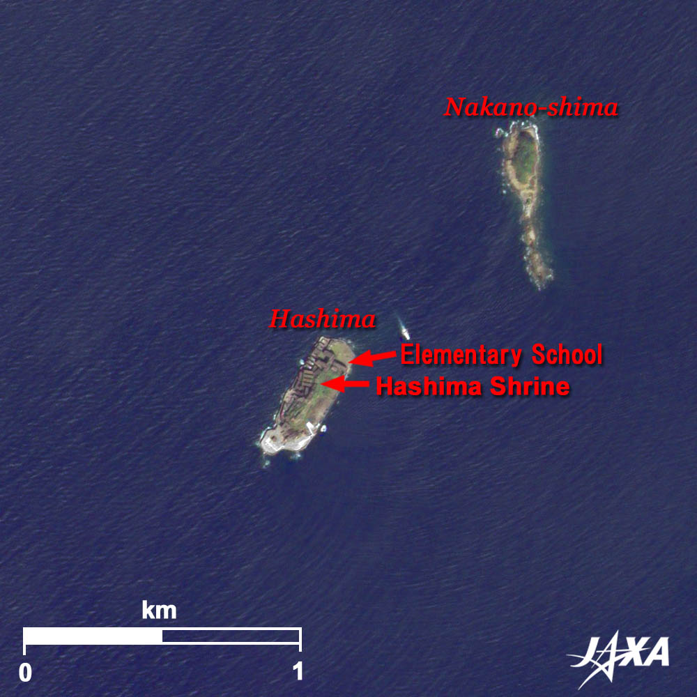  Fig. 4. Nakano-shima and Hashima (Warship Island)
Figure 4 is an enlarged image of Nakano-shima and Hashima. At Nakano-shima, coal was mined from 1883 to 1893. When spring water gushed out heavily, the island was abandoned, after ten years. Hashima (Warship Island) was originally a small shallow and was afterwards enlarged by reclamation. Coal was discovered in the Edo era (around 1810). Hashima, as well as Taka-shima, yielded high-quality coal, which supported the industrialization of Japan. Coal mining at Hashima operated from 1890 to 1974. The first reinforced concrete collective housing in Japan was constructed on Hashima in 1916. During the most prosperous period of the 1960s, more than 5,000 people lived there. There was an elementary school, a secondary school, a hospital and even a movie theater. But energy evolved from coal to oil and the mine was closed in 1974. The shape of this island looks like a warship; thus, it is called Gunkan-jima (Warship Island). You can see remains of the housing on the west side of the island. With the closure of the mines, people left the island. It eventually became uninhabited, and was prohibited from access. Nagasaki, the present holder of the island, prepared visitors routes and it became possible to land on the island from April 2009. The island was nominated to the interim list of the World Heritage as an “Industrialization Monument in the Kyushu/Yamaguchi District” in September 2008. It is hoped more people will visit. The images taken by ALOS (Daichi) are used in the background images of the Yahoo! Map. When you click the “Photo” button at the upper-left corner of the image, the background image changes to the Daichi image. Explanation of the Images: (Click the imaged twice to enlarge)
AVNIR-2 has four observation bands. The color composite images are usually produced by assigning red to Band 3 (610 to 690 nm), green to Band 2 (520 to 600 nm) and blue to Band 1 (420 to 500 nm). The resulting images have natural coloring as if seen by the naked eye. Each color indicates the following ground objects:
PRISM is an optical sensor for observing ground surfaces with visible and near-infrared signals in the 520- to 770-nanometer (one-billionth of a meter) band. The image is monochromatic but has a higher resolution. PRISM has three independent optical systems to acquire images in the view of nadir, forward, and backward simultaneously. Only the nadir image is used in these figures. The above AVNIR-2 color composite image is decomposed into, hue, saturation, and intensity. The intensity portion is replaced by PRISM data. The hue, saturation, and intensity data are then reversed into a color image. This color image has a virtual 2.5-m resolution. A color image composed by combining a higher resolution monochromatic image and a lower resolution color image is called a pan-sharpened image. |


