Seen from Space 2009
The Sand Dune of Tottori, Japan: A Site for Desertification Study
 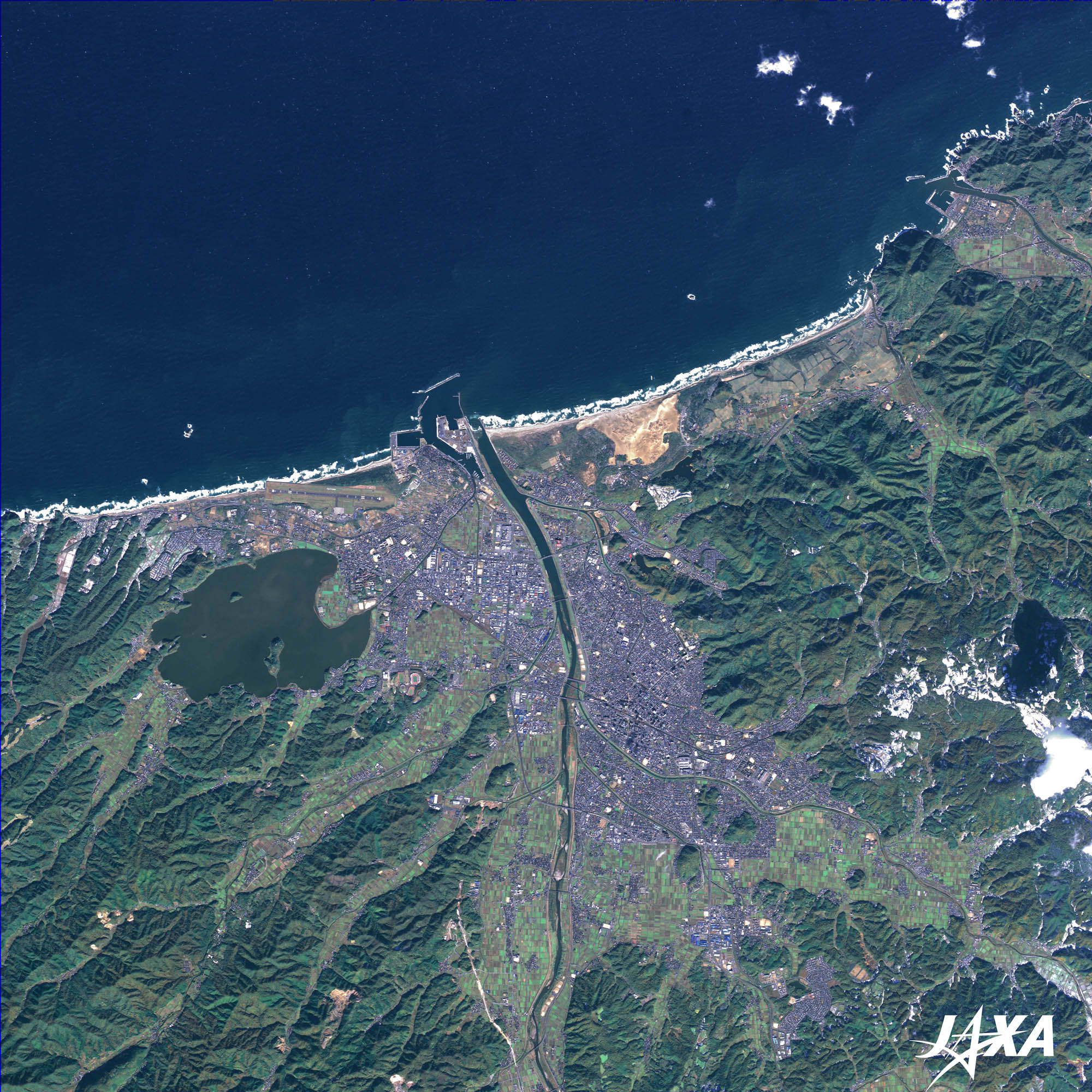 Fig. 1. Tottori Sand Dune and Its Surroundings
Tottori (kmz, 4.40 MB, Low Resolution) as seen on Google Earth Figure 1 shows the Tottori Sand Dune of Japan and its surroundings as observed by ALOS (Daichi) in November 2008. The Tottori Sand Dune is seen as light brown along the seashore in the middle of the image. Tottori is located in the mid-western part of Honshu, the main island of Japan, and faces the Japan Sea, which is visible in the upper part of the image. The Tottori Sand Dune, formed by the accumulation of crushed granite sand, is the largest one in Japan. The sand is carried from the mountains of the Chugoku district (mid-western Honshu) by the Sendai River, which can be seen in the middle of the image. The sand dune actually extends on both sides of the Sendai River, about 16 kilometers east-to-west and 2 kilometers north-to-south. The 2-kilometer-wide eastern part is called “Tottori Sand Dune” and is registered as a Natural Treasure of Japan. Tottori Airport is visible at the left side of the mouth of the Sendai River. You can see a white sand beach northwest of the airport. It is called “Hakuto (White Rabbit) Beach” and is a scene of the myth, “A White Rabbit at Inaba (the previous name of the area)”. There is a shrine dedicated to the White Rabbit there. You can see Lake Koyama-ike below the white beach. This is a brackish lake isolated from the sea by the beach and its water tastes a little salty. The quality of the lake has worsened recently due to the blue-green algae that have broken out. The lake is 18 kilometers around and 7.0 square kilometers wide, and is the largest lake in Japan to have “ike” (pond) in its name. The city of Tottori is visible as bluish-gray in the middle of the image along the Sendai River. Tottori Station and the prefectural office buildings are located in the center of the city. The Tottori Castle ruins are located at the top of Mt. Hisamatsu on the eastern side of the city. The ruins consist of the mountain castle built in the middle of Japan’s feudal period (around the sixteenth century) and a castle of early modern times. It is rare to find two types of castle ruins together, thus the ruins were registered as a National Historical Site in 1957. Tottori Castle is famous for the battle involving Toyotomi Hideyoshi (a feudal lord at that time),who cut off the supply of food to the castle during the battle. At present, the ruins of Tenshukaku (castle keep) and Ninomaru (secondary part of the castle) remain. Their surroundings have become Hisamatsu Park. The beach in the upper-right of the image–Uradome Beach–is registered as a National Park and famous for its beauty. It has about 15 kilometers of rias coastline, oddly shaped rocks, caves, and precipitous cliffs. The sea here has a 25-meter transparency when calm. 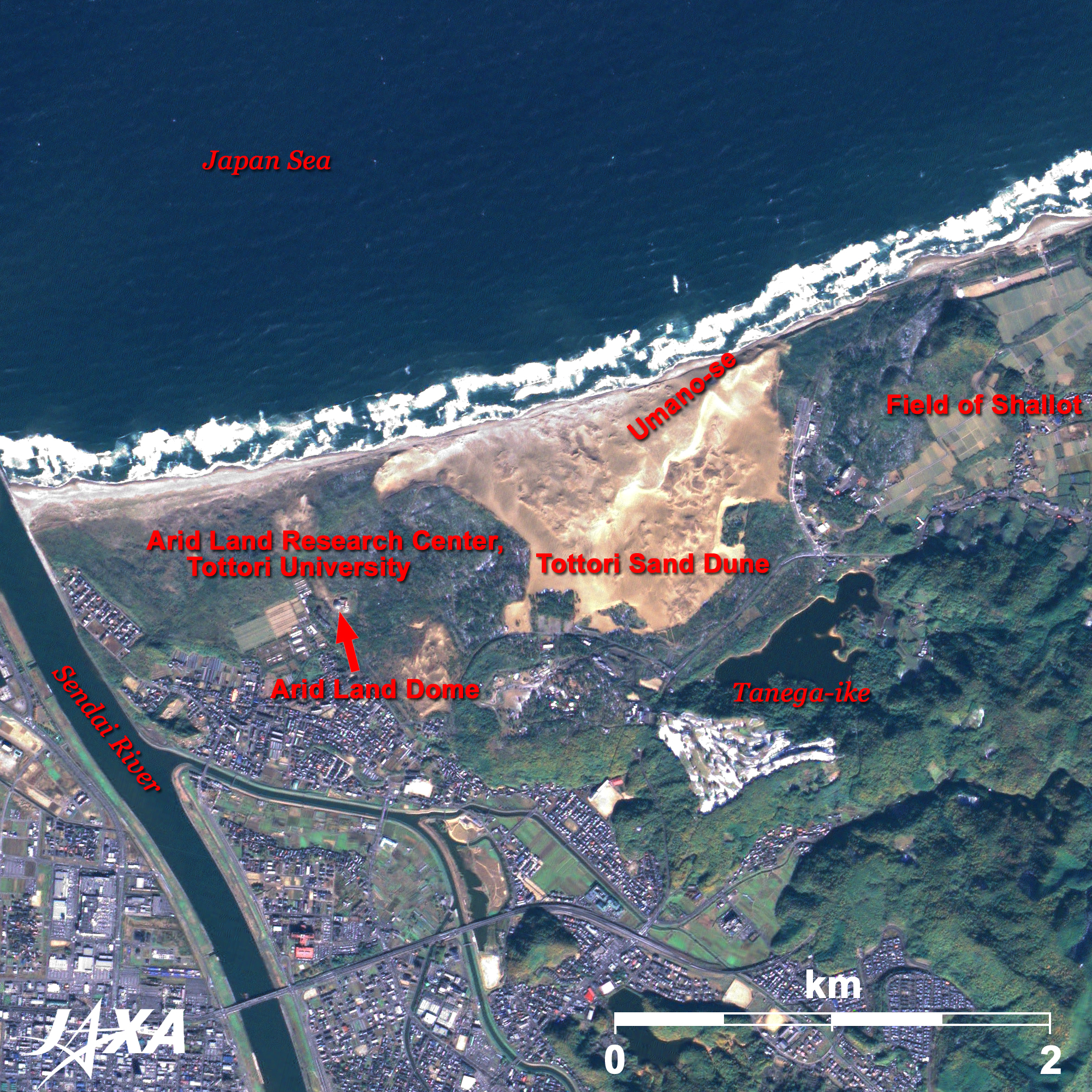 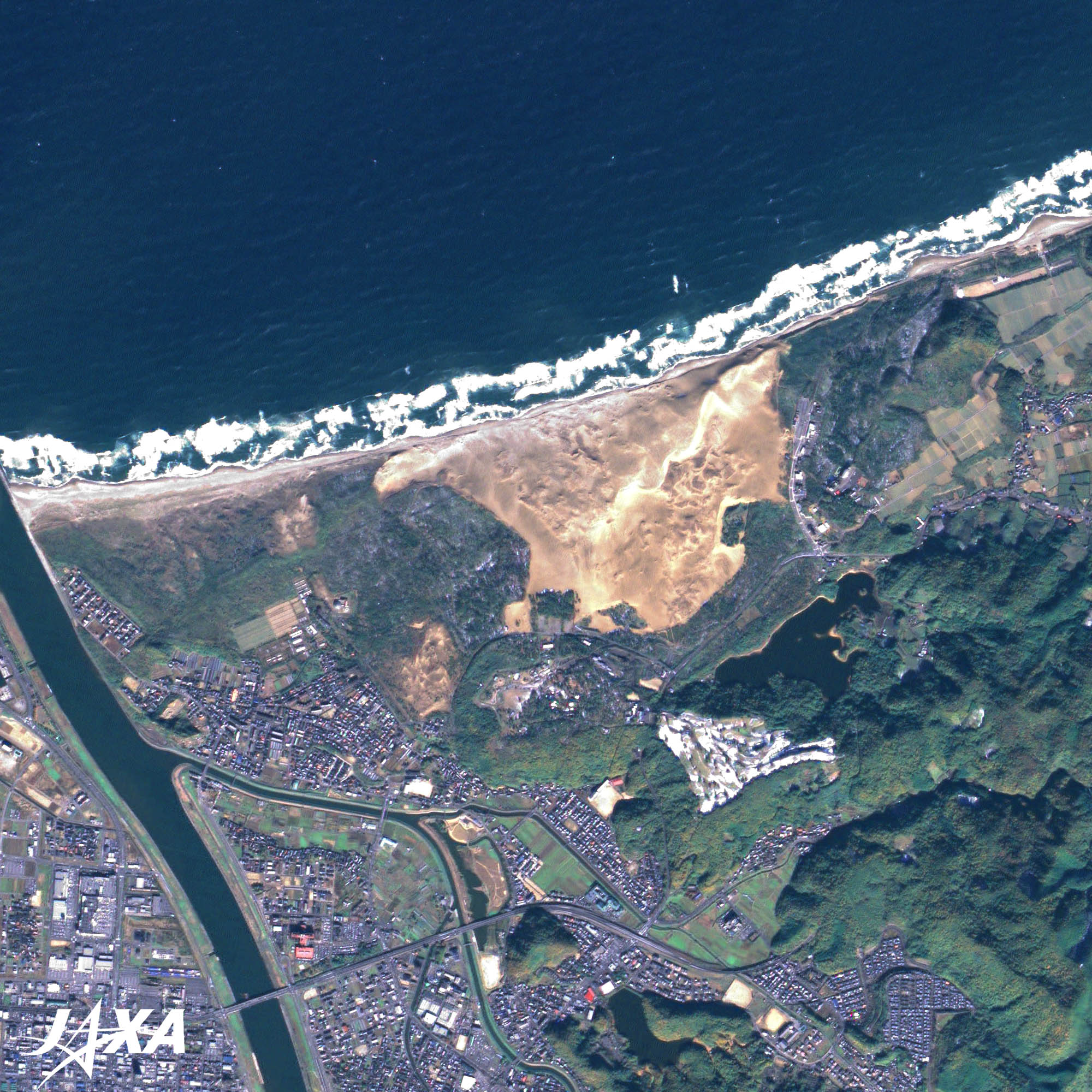 Fig. 2. Enlarged Image of the Tottori Sand Dune
Figure 2 shows an enlarged image of the Tottori Sand Dune. Umano-se (Horseback) Hill sits 40 meters high in the middle of the Sand Dune. Beautiful wind ripples are formed here and visitors can enjoy camel rides or horse-drawn carriages. A large pond called “Tanega-ike” is visible southeast of the sand dune. This pond was formed when the Tottori Sand Dune blocked the valley. The pond is closed now since it has no river from which to flow in or flow out. The deepest point is about 15 meters, the deepest in the Chugoku District. The eastern side of the sand dune is a field of shallots, the local specialty. Satellite images provide information on the growing stages of the crop and help to identify the time of harvest. Around the sand dune, trees were planted to protect cultivated area from the wind-blown sand and prevent the movement of sand; however, this in turn reduced the area of the sand dune because of expanding of grass fields. Therefore, some of the trees have recently been cut down. Satellite images are used to protect the environment, from such things as desertification. The Arid Land Research Center, Tottori University, was established in the area of the Tottori Sand Dune and is carrying out research to prevent desertification and to promote afforestation. It is small but it does not lack importance; the Tottori Sand Dune is being used to study and protect the global environment. The images taken by ALOS (Daichi) are used in the background images of the JAL_MAP. 
The Arid Land Research Center, Tottori UniversityThe Arid Land Research Center, Tottori University, was established in 1990 as a National Joint-Use Research Facility of the Ministry of Education, Culture, Sports, Science and Technology (MEXT). The center’s mandate is to conduct basic research on desertification, develop arid areas, and make the facilities available to university researchers. The center is now conducting joint research to prevent desertification and develop sustainable agricultural practices. The white dome, visible at the middle-left of the image, is called Arid Land Dome. It is about 37 meters in diameter, 16 meters tall, and 1,000 square meters wide. The Dome is used to simulate arid land conditions. Reference Sites:
Explanation of the Images: (Click the imaged twice to enlarge)
AVNIR-2 has four observation bands. The color composite images are usually produced by assigning red to Band 3 (610 to 690 nm), green to Band 2 (520 to 600 nm) and blue to Band 1 (420 to 500 nm). The resulting images have natural coloring as if seen by the naked eye. Each color indicates the following ground objects:
PRISM is an optical sensor for observing ground surfaces with visible and near-infrared signals in the 520 to 770 nano meter (one-billionth of a meter) band. The image is monochromatic but has a higher resolution. PRISM has three independent optical systems to acquire images in the view of nadir, forward, and backward simultaneously. Only the nadir image is used in these figures. |


