Seen from Space 2009
Le Mont-Saint-Michel
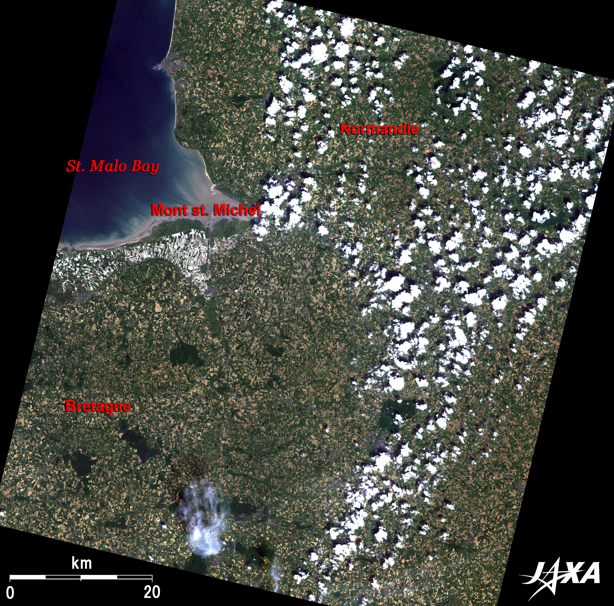  Fig. 1. Vicinity of the Gulf of Saint-Malo, France
Figure 1 depicts the vicinity within the boundaries of Brittany (Bretagne Peninsula) and Normandy (Normandie or Cotentin Peninsula) in northern France as observed in mid-June 2008. The dark blue sea on the upper left of the figure is the scenic Gulf of Saint-Malo. The tides vary greatly here, at roughly 15 meters between high and low tide, and thus a vast mudflat appears in the deep cove of the gulf and along the coast of Brittany at low tide. The figure shows reddish brown muddy water drifting out to the offing. The rich natural environment of the mudflat is suitable for the cultivation of oysters and blue mussels. The coastal area at Brittany is particularly famous in France for aquafarming. Le Mont-Saint-Michel, the most renowned French commune located 300 km west of Paris, is visible as a tiny green spot of island (500 m in diameter) on the mudflat at the head of the Bay of Mont-Saint-Michel. According to legend, Mont-Saint-Michel, meaning “Saint Michael’s Mountain”, is the miraculous island where the Archangel Michael appeared. France is the largest agricultural country in EU (European Union), which is 1.5 times larger than Japan. As seen from the figure, farmlands, looking like gold foil scattered over the vast green grassy continent, reveal the great agricultural power of France. However, the coastal region of the Brittany looks rather white in comparison as the result of the reclamation of the mudflat in the Bay of Mont-Saint-Michel. Conversion of the mudflat to farmland through large-scale reclamation work was performed in the nineteenth century. 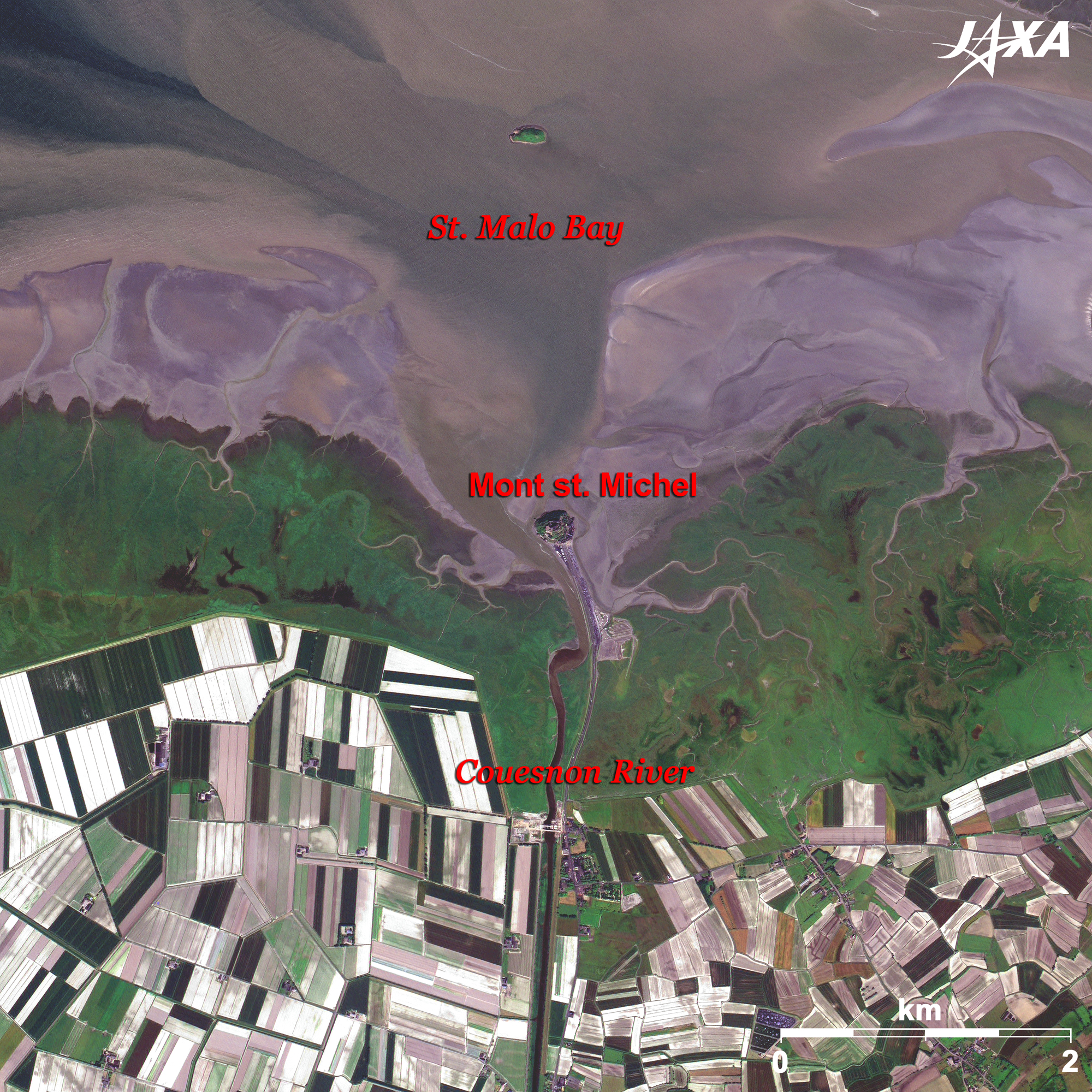  Fig. 2. Close-up of the Vicinity of Mont-Saint-Michel
Figure 2 presents a close-up image of the vicinity of Mont-Saint-Michel. The small round island on the mudflat in the center of the image is Le Mont-Saint-Michel. It is close to the mouth of the Couesnon River, which marks the boundary between Brittany and Normandy. Le Mont-Saint-Michel has flourished for about 1,000 years as an important pilgrimage site of Western Europe. An abbey was established here in 708. A causeway was built between the island and the mainland in the nineteenth century, which helped pilgrims to avoid the dangerous walk across the mudflat to and from the island. However, this causeway posed a problem when it changed the current of the bay and prevented the tide from scouring the silt deposited around the island. Some parts of the mudflat have already turned into grassy fields and have reached close to the island; thus, the mystic sight of the solitary island in the sea has almost faded away. Farmland, which was once the mudflat, spreads out next to the grassy field, showing the beautiful geometrical pattern colored with white, green, and brown. Today, one can see a pastoral scene of a flock of sheep leisurely grazing against the abbey soaring over the horizon. 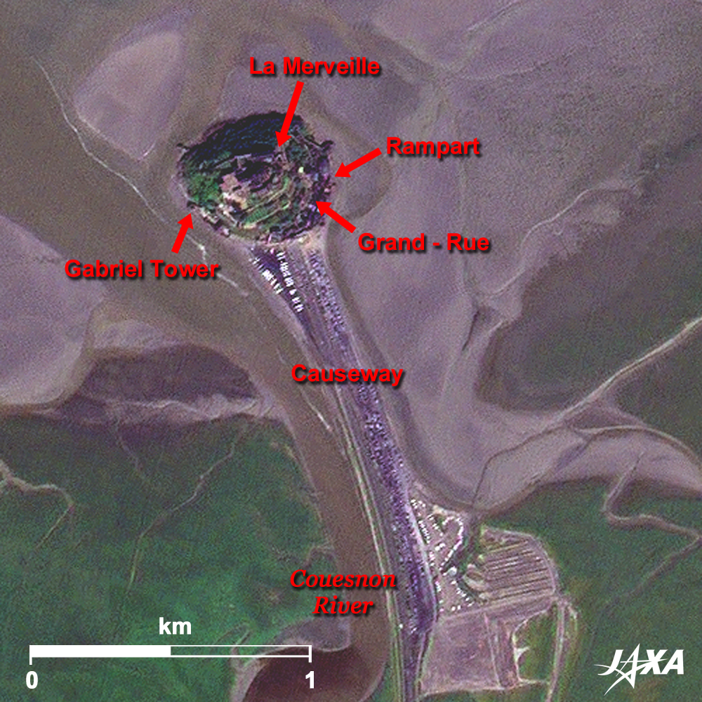 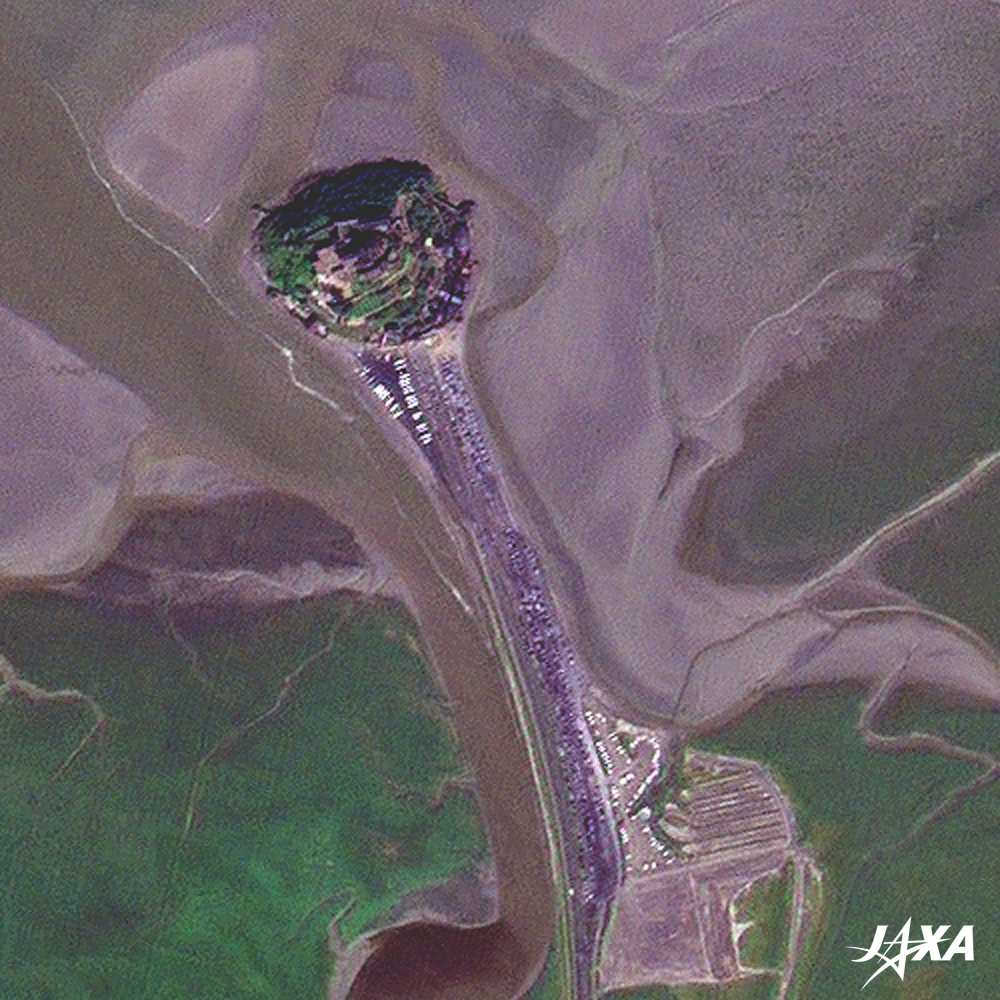 Fig. 3. Close-up Image of Mont-Saint-Michel
Le Mont-Saint-Michel(kmz, 3.11 MB, Low Resolution) as seen on Google Earth. Figure 3 is a close-up image of Mont-Saint-Michel. The building seen in the center of the island is the abbey. There is quite a lot of green on the island, but the fantastic silhouette, like a fortress soaring in the sky, is hard to imagine from the image. Today’s form was established when a Gothic-style Benedictine abbey, with beautiful galleries and a dining room known as “La Merveille” (the Wonder) at the north side, was built in the thirteenth century. It was fortified during the Hundred Year’s War in the fourteenth century. Vestiges of those days can be found at military installations, such as the rampart, and Gabriel’s Tower, which was used as a crow’s nest. At the end of the eighteenth century, it was used as a prison after the French Revolution because of the island’s isolation. Le Mont-Saint-Michel is the most popular commune in France, which 3 million tourists visit per year. “Mont-Saint-Michel and its Bay” was added to the World Heritage List (Cultural Heritage) of the United Nations Educational, Scientific, and Cultural Organization (UNESCO) in 1979. It was also added to the list of the Ramsar Convention on Wetlands in 1994. In response to the rise of global environmental consciousness in recent years, a large-scale civil engineering project to eliminate the accumulated silt deposited around the island began in 2006. This ambitious project to build a hydraulic dam at the mouth of the Couesnon River and to span a bridge instead of the causeway will help regain the current flow of the past and make Le Mont-Saint-Michel a mystic island again. When the project is complete in 2012, the abbey known as “The Marvel of the West” will once again reflect its lofty figure on the Bay of Mont-Saint-Michel. Explanation of the Images: (Click the images twice to enlarge.)
(Figs. 1, 2, and 3)
(Figs. 2 and 3) |


