Seen from Space 2009
India's green-rich Capital, Delhi
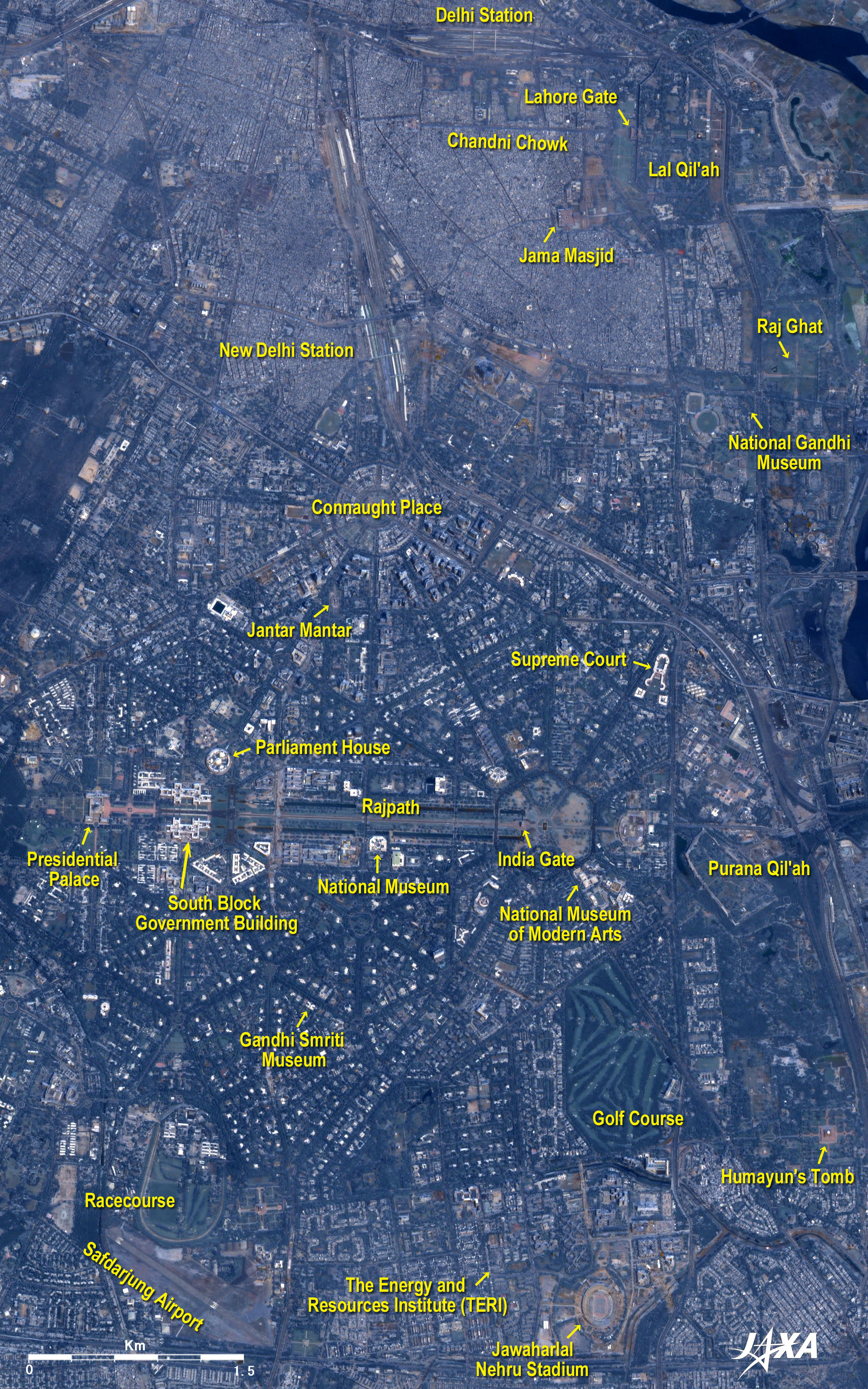
The area in the upper right of the figure is Old Delhi, and you can see the Red Fort Complex (Lal Qil’ah in Hindi), which was added to the World Cultural Heritage list of the United Nations Educational, Scientific and Cultural Organization (UNESCO) in 2007, and India's biggest mosque, the Jama Masjid. These buildings were constructed by the fifth Mughal Empire Shah Jahan (1592 to 1666), who also built the Taj Mahal. The Chandni Chowk, a busy shopping street in Old Delhi, extends westward from the Lahore Gate, the main entrance of the Lal Qil’ah. On the northern side of this avenue you can see the Delhi station (Old Delhi Station), terminal for the train linking Delhi to Jaipur, the state capital of Rajasthan. In contrast to the old city, New Delhi, in the center of the figure, is an area of well-regulated streets. The Rajpath (meaning the road of the king) extends in the east-west direction, linking the Presidential Palace and the India Gate. The India Gate was built to be the cenotaph of the Indian soldiers killed in World War I and was completed in 1971. On the northern side of the Rajpath, the avenues extend radially from Connaught Place, at the center of New Delhi, and the India Gate. The avenues cross each other, creating a thick green triangle-and-square pattern with sides hundreds of meters long. A similar pattern is seen on the south side of the Rajpath, and the many green areas are dotted with white buildings, making them truly green-rich areas. To the north of Connaught Place is New Delhi Station, which serves the long-distance trains that link Delhi to metropolises such as Kolkata, near the Bay of Bengal, and Mumbai, facing the Arabian Sea. There is an observatory called Jantar Mantar, which Maharaja Sawai Jai Singh II (1688 to 1743) of Jaipur built in the time of the Mughals, southwest of Connaught Place. It remains a major astronomical observation facility and is home to the world's largest sundial. In the expanded image, about 30 skyscrapers are visible in three dimensions southeast of Connaught Place. The figure appears as a bird's eye view due to the backward image from PRISM used when making the figure. There is a key-shaped Supreme Court building northeast of the India Gate. The North and South Block Government Buildings, which house the offices of the ministries, are located along the eastern side of the presidential palace, with the Rajpath between them,. The office of the Prime Minister is located in the South Block Government Building. The nominal leader of India is the President, chosen by election, but many of his or her duties are ceremonial. The leader in the majority party in the Parliament is designated as the Prime Minister and serves as the true leader of the Indian government and the cabinet. The wheel-shaped Parliament House (Sansad Bhavan) can be seen to the northeast of the North Block Government Building. The National Museum is near the India Gate and the National Museum of Modern Arts is southeast of the gate. These buildings all appear white except for the gray Presidential Palace. After the relocation of the capital of British India from Calcutta (presently Kolkata) to New Delhi was declared in 1911, the project of constructing the new capital was undertaken by British architects; the relocation was formally completed in 1931. The Republic of India achieved independence on August 15, 1947, but the government buildings have remained in use, with the Viceroy's House serving as the Presidential Palace (Rashtrapati Bhavan). The circumvallation of Purana Qil'ah (the Old Fort), which the second Mughal Emperor, Humayun (1508 to 1556) used as his castle, can be seen to the east of the India Gate. There also is Humayun's Tomb, which influenced the Taj Mahal and is located south of the Qil'ah. "Humayun's Tomb, Delhi" was added to the World Cultural Heritage list maintained by UNESCO in 1993. Gandhi Smriti Museum, southwest of the India Gate, is the place where Mahatma Gandhi (1869 to 1948), the father of India's independence, lived. Also, the memorial park where Gandhi was cremated, called Raj Ghat, is south of the Lal Qil’ah, and the National Gandhi Museum is nearby. Jawaharlal Nehru Stadium, named after the first prime minister of India, can be seen at the bottom of the figure. This multipurpose stadium was completed in 1982. It can accommodate an audience of 78,000 for sporting events like soccer, and 130,000 for concerts. The Energy and Resources Institute (TERI) is located to the west of the stadium. In 2007, the Nobel Peace Prize was awarded to the Intergovernmental Panel on Climate Change (IPCC) and to Al Gore, former vice-president of the United States of America. Dr. Rajendra K Pachauri, the third chairperson of the IPCC, serves as the Director-General at this institute. Safdarjung Airport, in the lower left of the figure, served as the front door of Delhi until 1962, when all regular civilian flights were moved to Palam Airport (now called the Indira Gandhi International Airport). At present, Safdarjung Airport is used for non-regular civilian flights using small propeller aircraft. In addition, a golf course and a racetrack can be seen in the lower half of the figure.
Extended city areas and green areas dot the entire image. Central Delhi is located in a position protected by the Delhi Ridge to the west and the Yamuna to the east. The Yamuna flows to the southeast, just grazes the Taj Mahal 200km downstream from here, and finally joins with the Ganges 570km downstream. A lotus-shaped temple called the "BahEEHouse of Worship" can be seen as a white point southeast of central Delhi. Southwest of central Delhi is Qutb Minar with its 72.5m high brick minaret. The "Qutb Minar and its Monuments, Delhi" was added to the World Cultural Heritage list of UNESCO in 1993. A miraculous iron pillar 7m tall, which has no rust even though it was built in the fourth century, stands near the minaret. Indira Gandhi International Airport can be seen to the west of Qutb Minar, and Hindon Air Force Base is to the northeast of central Delhi.
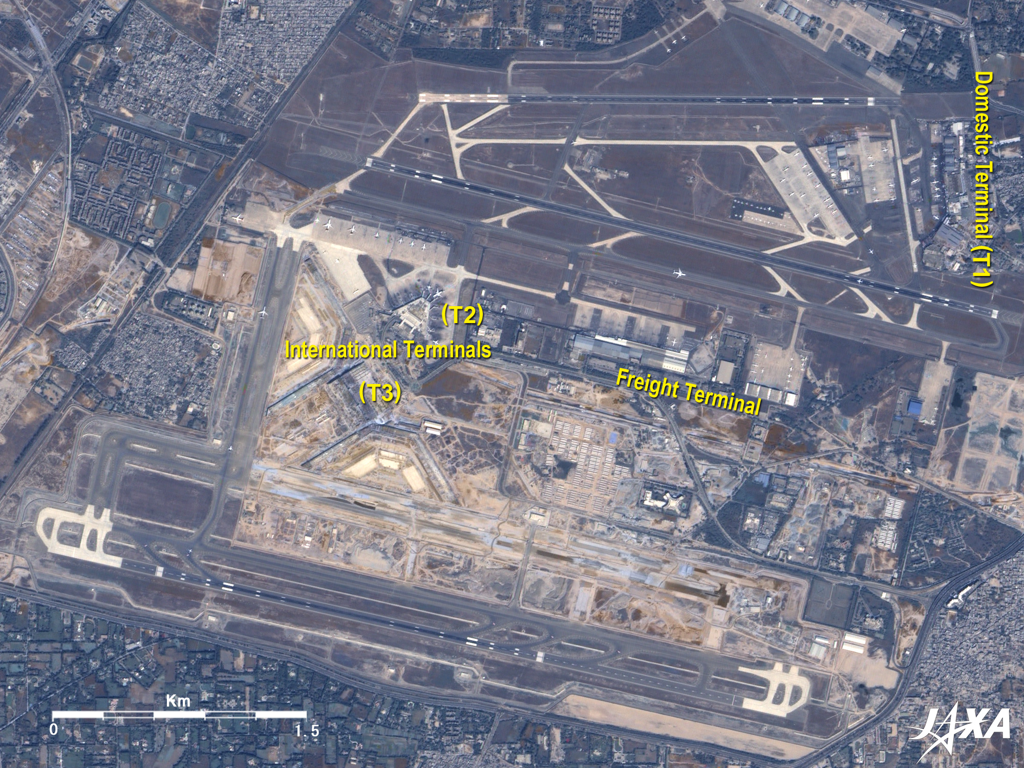
There is a short 2900m runway to the north, and to the south of that, a longer 3900m runway can be seen. The terminals are arranged in a dispersed manner: the domestic terminal (T1) to the upper right, the freight terminal in the center of the figure, and the international terminal (T2) to the center left of the figure. The international terminal (T3) is under construction and will be completed in March 2010. The long runway at the bottom of the figure is a new one, put into service in September 2008. If you examine the expanded image, you can see many aircraft parking or moving on the taxiway.
|