Seen from Space 2008
"Island of the Gods"–Bali, Indonesia
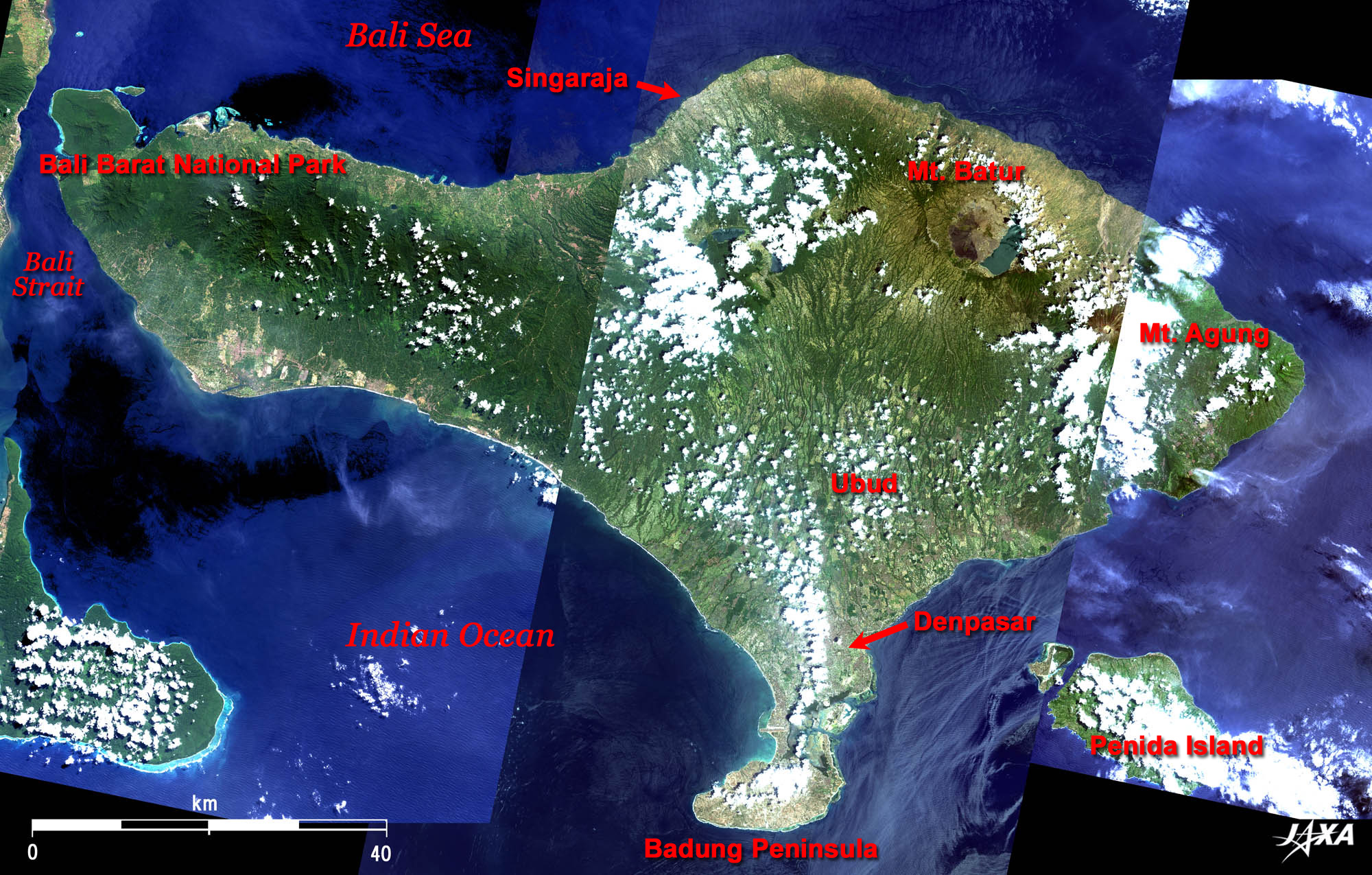
Figure 1 is composed of the three images with the least cloud cover so far observed by ALOS Daichi. Green in the three images has been adjusted so that the differences should be minimal. However, adjoining parts look somewhat unnatural due to the differences of cloud cover and the seasonal state of the plants that cover the surface. Nevertheless, deep green mountains in the west are clearly visible. Bali Barat National Park on the west side of the island is a wildlife reserve where Bali’s endemic white bird, Jalak Putih (Bali Starling), is carefully protected. In the east of the island, Mt. Agung (3,142m), the highest peak of the island, and Mt. Batur (1,717m) covered with a dark-brown exposed lava field are visible.
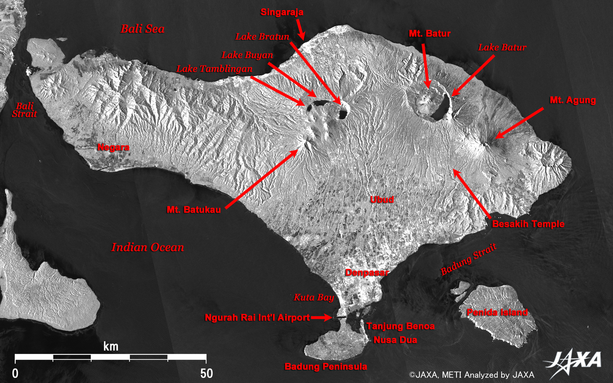
Although there are some lakes near Mt. Batukau (2,276m) and other mountains in the center of the island, the rain brought by the north wind falls at the mountains and mostly flows northward, which makes the south side of the island a dry desert. It is said that people dug tunnels so water could flow from the lake to the south and turned the entire south of the island into sylvan land. Smooth water surfaces or flat ground objects, such as the sea, lakes, or airport runways, do not reflect much of the signal back to the satellite and so look darker. Urban areas in Singaradja and Denpasar are also bright, indicating that buildings reflect radar signals quite strongly. Resort areas facing Kuta Bay and on the east of Badung Peninsula also look white. Mt. Agung erupted in 1963, but the Mother Temple of Besakih, located on the southwest foot of the mountain and the head temple of Balinese Hinduism (Agma Hindu Dharma in Bali), is always crowded with worshippers. To its northwest, Mt. Batur, which erupted in 1917 and 1926, and the caldera Lake Batur are visible. Other caldera lakes seen further west are, from east, Lake Bratan, Lake Buyan, and Lake Tamblingan. From there, many valleys run down the slope toward the south and extend to the farmlands on the alluvial plain where Denpasar is located. The many black dots scattered over the plain are thought to be water-laden paddies. These paddies are also visible in Negara district southwest of the island.
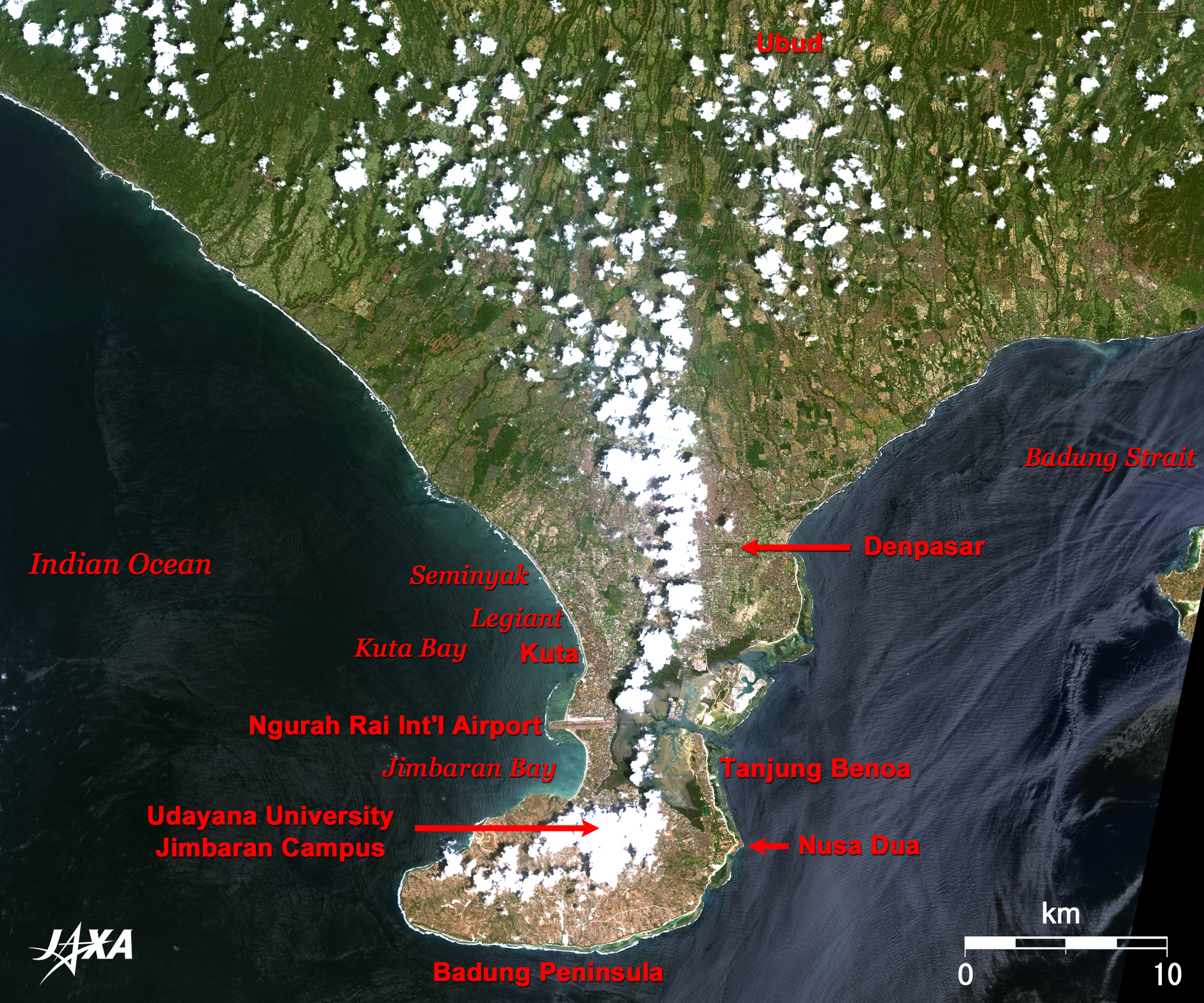
The urban area of Denpasar is located south of Ubud. This area is the political and economical center of Bali where government and companies maintain their offices. To the south of Denpasar, Ngurah Rai International Airport lies in the narrowly pinched portion of Badung Peninsula. In the resort area to the north of the airport (white area in Fig. 2), shops and hotels cluster and look grey or brownish-red. They are, from south, Kuta, Legian, and Semynyak. Kuta and Legian are the most crowded beach resorts in Bali. These were peaceful fishing villages before many surfers from Australia and Europe came from the 1960s. The sleepy villages rapidly developed since then and are now crowded with young people day and night. In contrast, Semynyak gives the impression of a quiet and fashionable town. Many foreign residents settled there and started businesses of shopping, restaurants, spas, and boutique villas. Tanjung Benoa area to the north of Nusa Dua and southeast of the airport is an exclusive beach resort developed in a government-led plan from the 1970s. Only roads can be seen in the light-brown area south of the peninsula, which is due to be developed in the future. Udayana University Jimbaran Campus is located about 5km south of the airport but unfortunately it is hidden below the white cloud. The Center for Remote Sensing and Ocean Science of Udayana University (UNUD/CReSOS), established in 2003, participates in the "Pilot Project on Utilization of ALOS Data in Indonesia" based on an agreement between JAXA and the National Institute of Aeronautics and Space (LAPAN) and conducts application research for the coastal zones of Indonesia.
|