Seen from Space 2008
Monaco: The Resort-Oriented Nation of Côte d'Azur
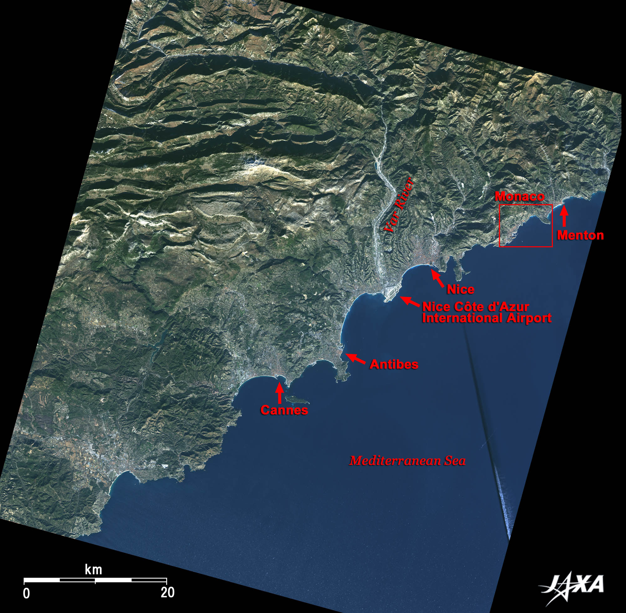
The prominent white feature in the center of the figure near the mouth of Var River is the Nice Côte d'Azur Airport with an area of 3.7km2. The red square indicates the vicinity of Monaco. Monaco is the world's second smallest country with about 2km2 total area (about half the size of the Côte d'Azur Airport) following the Vatican and with a 4-km coast line that extends into France. The black-and-white straight line in the lower right of the figure is a jet contrail and its shadow. The contrail just happens to be in line with the sun, so it looks like a scratch on the picture.
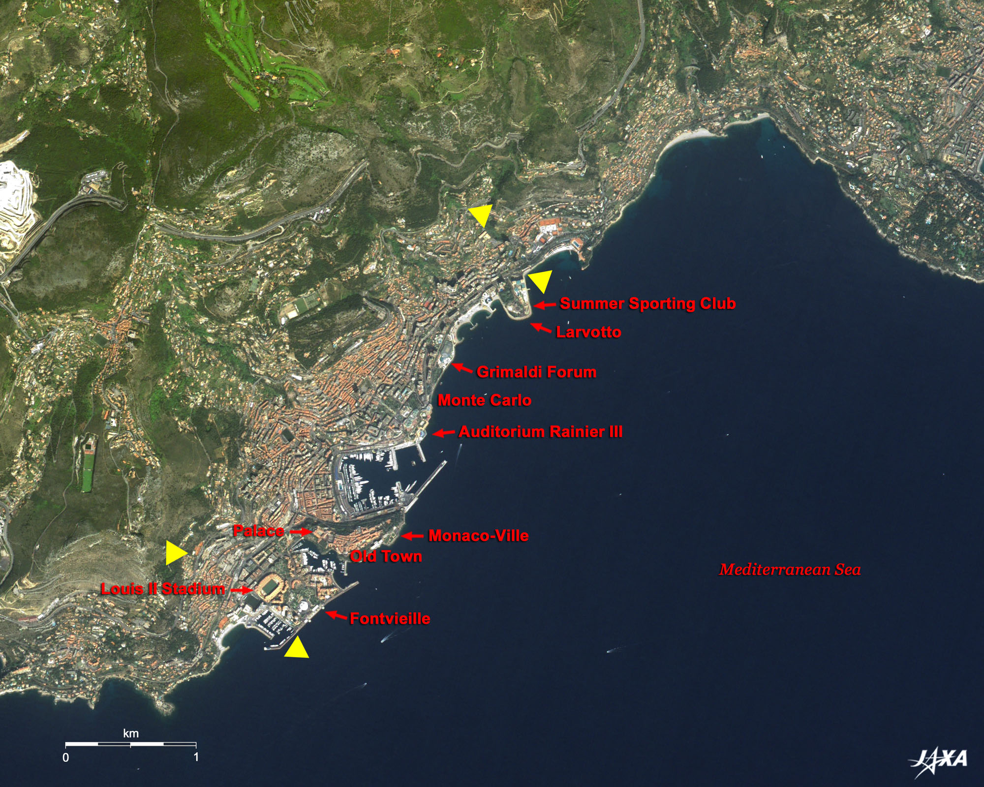
Monaco first appeared in historic documents in the times of ancient Greece and the Roman Empire. It was a natural harbor for vessels and became famous among the people who sailed in the Mediterranean. It is recorded that Julius Caesar stopped over at Monaco on his triumphant return to Rome from the Gallic Wars (58 B.C. - 51 B.C.), but it was not until the 12th century that Monaco appeared again in history. The Great Roman Empire ruled this area, but actually the administrative ruler of Genova held the reins of the area extending from Monaco to Liguria (northwest of Italy and southeast of France) along the coast of the Mediterranean. In those days, northern Italy was involved in a power struggle between the Pope and the emperor of Germany (who was also the emperor of the Great Roman Empire). In the middle of the early 13th century, the first fortress was built during the war on the rocky mountain where the palace is located today. In January 1297, François Grimaldi of the party backing the Pope disguised himself as a friar, climbed the bluff, broke into the fortress, and defeated the party backing the German emperor. Grimaldi's family has reigned over Monaco and prospered ever since. This is the area of Monaco-Ville, and people endearingly call it "Rocher (the rocky mountain)." The terra-cotta roof visible in the west is the Palace of Monaco. The area of clustered roofs in the east is old Monaco. The glorious history of modern Monaco began in the Belle Époque era in which modern Europe was formed, and European elegance bloomed in the mid-19th century. In those days, Monaco had lost its territory and economic bases and was reduced to a small village without any attractive industries. However, Charles III, the leader of the Grimaldi, introduced a casino, which became a social haunt of royalty, the aristocracy, and the rich. He also built hotels and developed bathing beaches. Since then, Monaco developed as a tourist resort town, and the newly developed coast-line area was named Monte-Carlo in 1866. Today, it is the center of Monaco where more than five million tourists and participants for conventions visit from all over the world every year. One of the most famous events is the F1 Monaco Grand Prix held since 1929 around May each year (interrupted from 1938 to 1947 due to World War II). The motor racing takes place in the Monte Carlo city area of 3,340m and covers 78 laps of the city in about two hours. The hexagonal building with the iridescent roof on the coast is the convention center (Auditorium Rainier III opened in 1979). Five luxury hotels, a 130-year-old historic casino, many restaurants, cafes, swimming pools, nightclubs, discotheques, movie theaters, and fancy boutiques are gathered within a 220m circle around the convention center. Larvotto area to the northeast of Monte-Carlo is on reclaimed land. A leisure facility, named "Sporting Monte-Carlo" is located on the eastern end of the area. Public beaches and a new convention center (Grimaldi Forum Monaco) completed in 1994 with a large green Japanese garden are located toward the west. The Fontvieille area, which has yacht basins on both sides, is located to the south of Monaco-Ville. This is reclaimed land and was completed in 1972, expanding Monaco's territory by 16%. Louis II Stadium, which, if necessary, can accommodate half of the population (32,020 at the time of the 2000 national census); Princess Grace Rose Garden; a heliport; office buildings; an electric/gas office; and a waste incineration plant that perform vital functions for Monaco, are located in this area. Furthermore, pollution-free industries such as cosmetics, medical supplies, and precision machinery components, which do not spoil the environment or the image of Monaco, are carefully selected and invited. In 2006, 52% of the annual revenue of the government of Monaco was sales tax from the tourist business and conventions, and only 5% of it was from the casino. Monaco is completely free from casino dependence. Diplomatic relations between Monaco and Japan were established in December 2006, and His Serene Highness Prince Albert II of Monaco visited Japan in April 2007.
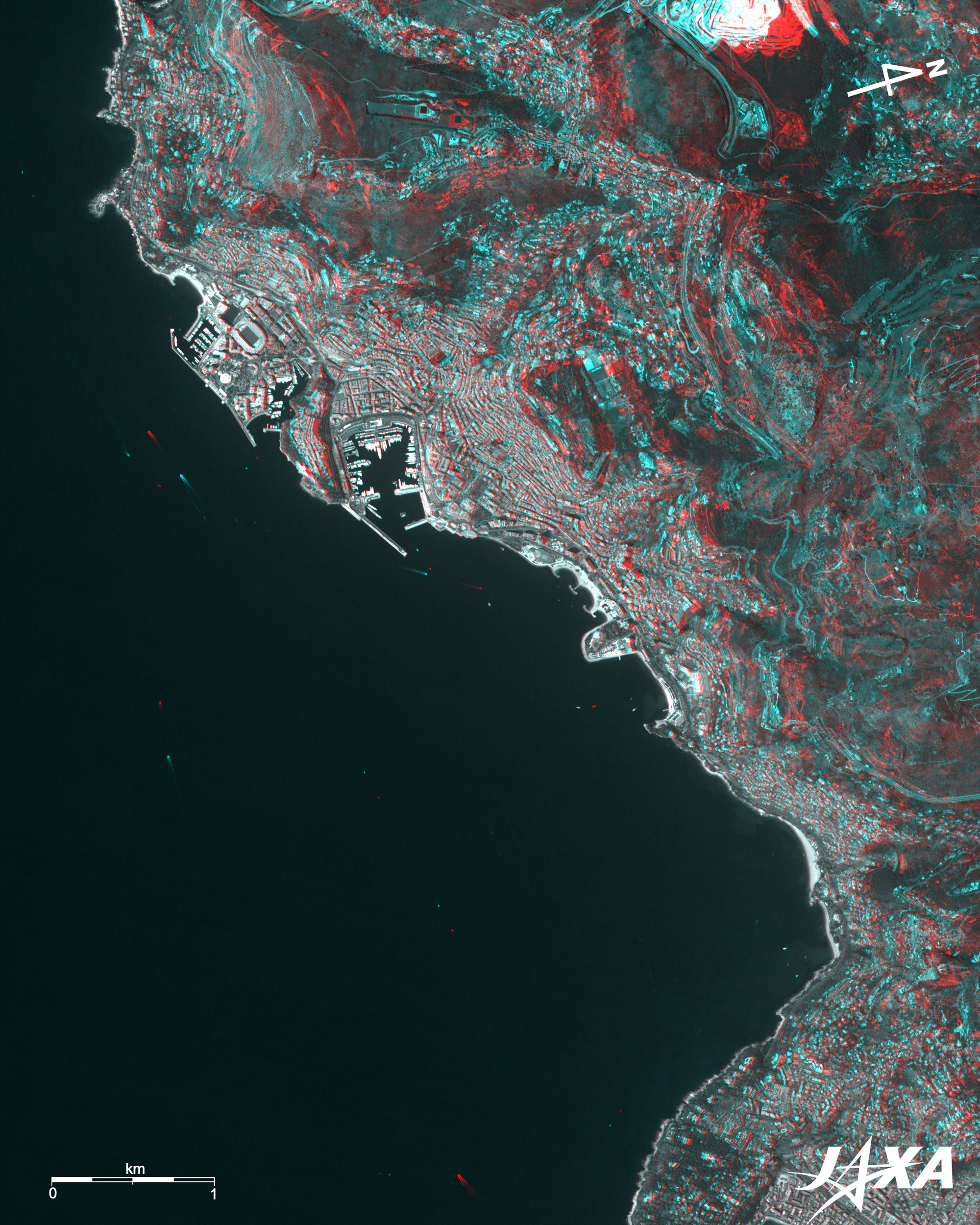
Fig. 2. PRISM is an optical sensor for observing ground surfaces with visible and near-infrared signals in the 520 to 770 nano-meter (one-billionth of a meter) band. The acquired image is monochrome. PRISM has three independent optical systems (telescopes) to acquire images for nadir, forward, and backward views at the same time. Only the nadir image was used in this article. The AVNIR-2 composite image was then transformed into hue, saturation and intensity, and the intensity was replaced by the PRISM image. The hue, saturation and intensity data were then reversed into a color image. As a result, a virtual 2.5-m ground-resolution color image was obtained. This kind of high-resolution color image, composed by combining the higher resolution monochrome image and the lower resolution color image, is called a pan-sharpened image. Figure 2 is a high-resolution pan-sharpened image composed in this way. Fig. 3. Figure 3 combines backward (red) and nadir (green and blue) images of PRISM. The left eye sees the backward image, and the right eye sees nadir image, which means the left side corresponds to the satellite flight direction (south) and left side corresponds to south. Note that upward is north in Figs. 1 and 2, but right is north in Fig. 3. |