Seen from Space 2008
Salzburg, Birthplace of Mozart
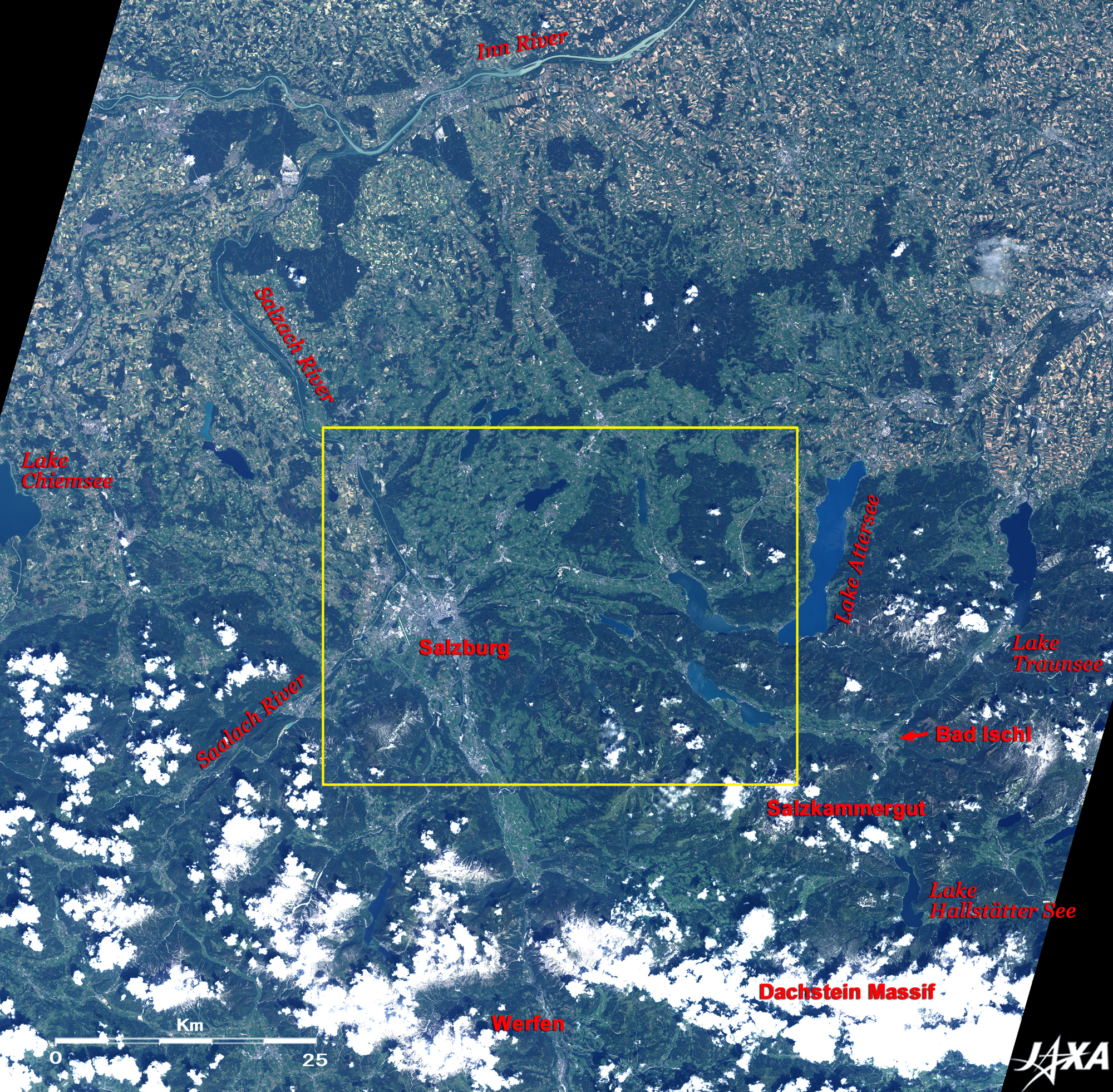
East of Salzburg is Salzkammergut, a scenic area interwoven with lakes and mountain ranges. The lakes in this area are tarns, made from water collecting in hollows formed with glaciation. Salzkammergut means the Habsburg's "estate of the salt chamber." On the west coast on Lake Hallstätter in the lower right of the figure is Hallstatt, the world's oldest salt deposit where the major-scale rock salt mining can be traced back to the middle of the 2nd millennium BC. Therefore, "Hallstatt-Dachstein Salzkammergut Cultural Landscape" was added to the World Heritage list of the United Nations Educational, Scientific and Cultural Organization (UNESCO) in 1997. Also, the summer villa that the Austrian Emperor Franz Josef (1830-1916) built is located in Bad Ischl (Spa Ischl). There is a huge ice cave named Eisriesenwelt, the largest in the world, near the town Werfen at the bottom of the figure. Salzburg's city area and Salzkammergut were used as settings for the American movie "The Sound of Music."
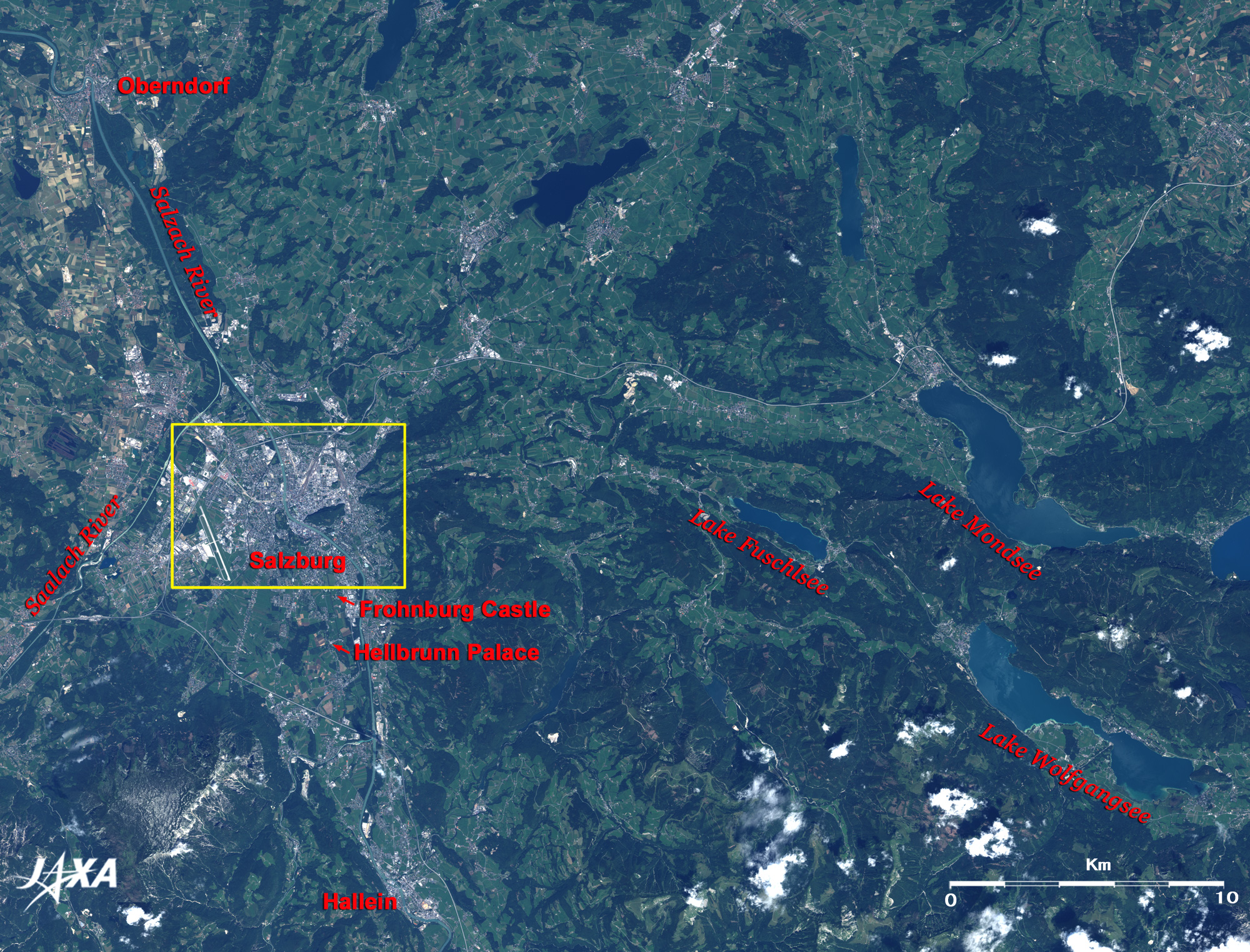
"Salz" in Salzburg means salt and "burg" means castle. The rock salt mined in Hallein at the bottom of the figure was carried via the Salzach River, and the city has been known for rock salt trade since ancient times. The village Oberndorf lies where the Salzach River makes a hairpin curve at the top of the figure. The village once had the church where "Silent Night" was composed and first performed at Christmas in 1818. However, floodwaters washed the church away, and it has now been replaced by the Silent Night Memorial Chapel and the Silent Night Museum. You can find the three lakes that appeared in "The Sound of Music" on the right of the figure. Lake Fuschlsee appeared in the opening; the church at the northwestern end of Lake Mondsee was used as the venue for the wedding of Maria and Captain von Trapp; and Schaafberg Railway, which is drawn by steam locomotive along the northern coast of Lake Wolfgangsee, appeared in the junket scene. Also, Frohnburg Castle and Hellbrunn Palace, which were built in the 17th century in the suburbs in the south of Salzburg, appeared in this movie.
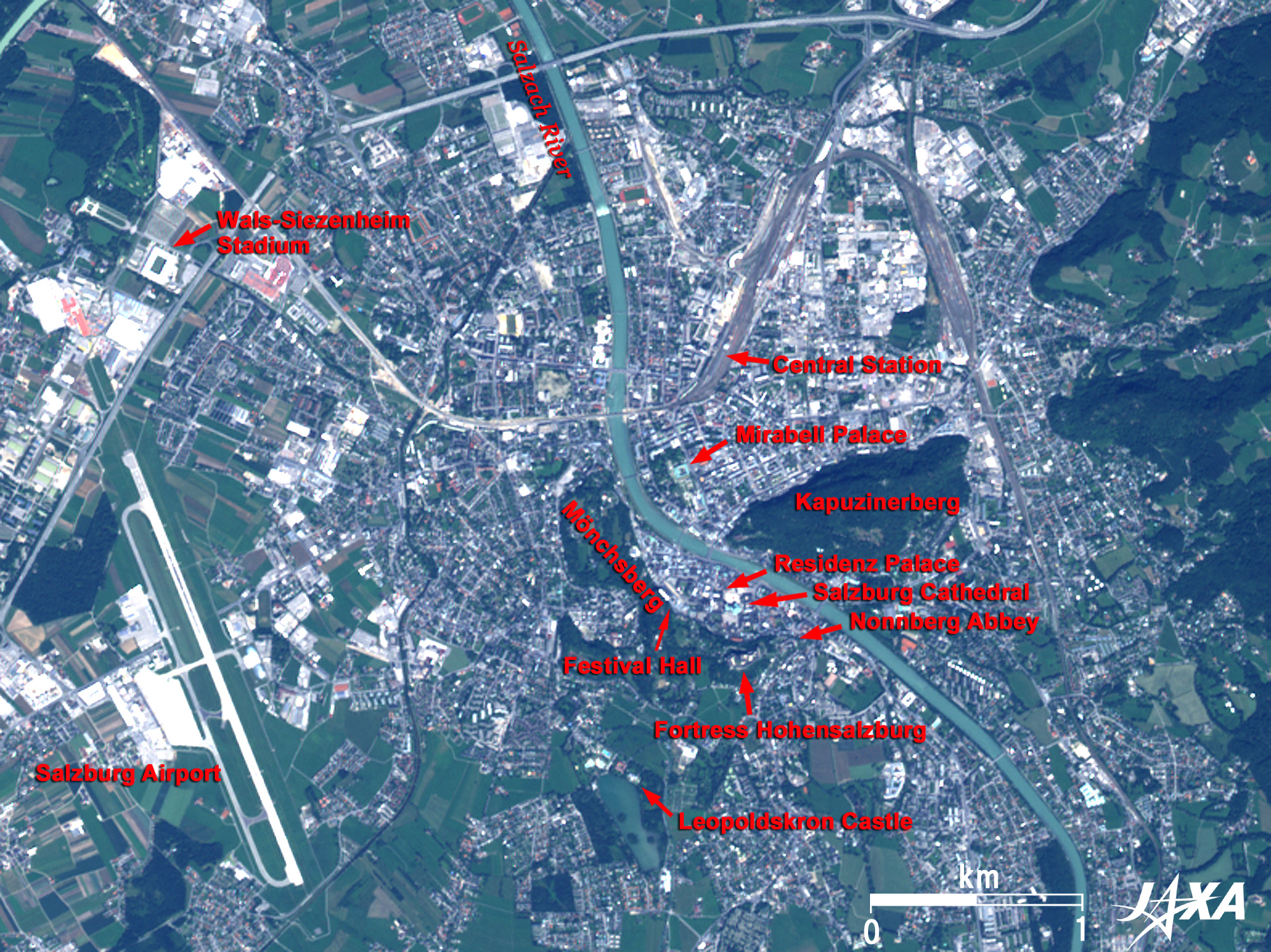
The old town containing these buildings was added to the World Cultural Heritage list of UNESCO in 1996 as "Historic Centre of the City of Salzburg." In the new town on the northeastern side of the Salzach River, the Mirabell Palace, which was built in 1606, can be seen as an emerald-green square frame. Mozart's home as well as the birthplaces of Herbert von Karajan (1908-1989), who was the greatest conductor in the 20th century, and Christian Doppler (1803-1853), who discovered Doppler effect, lie just 350m south of the Mirabell Palace. Salzburg Central Station can be seen in black north of Mirabell Palace. Because Salzburg is situated near the border with Germany, it takes just one and a half hours to Munich by the EC (EuroCity: the international limited express trains), but it takes three hours to Vienna by the EC or ÖBB -EC (the domestic limited express of the Austrian Federal Railways). International trains linking Zurich in Switzerland, Zagreb in Croatia, Ljubljana in the Republic of Slovenia, and Budapest in Hungary also use this station. Salzburg W. A. Mozart International Airport can be seen on the left of the figure. Flights linking Salzburg with Berlin, London, Paris, St. Petersburg, Vienna, Zurich, etc. transit this airport. The Wals Siezenheim Stadium, the home ground of Red Bull Salzburg, which won the victory in Austrian Bundesliga's season in 2006-2007, can be seen north of the airport (white square frame). Two players from Japan, Tsuneyasu Miyamoto and Alessandro dos Santos, have been members of the team since the end of 2006. The father of Wolfgang Amadeus (W.A.) Mozart was the court musician of Salzburg. He noticed his son's genius for music and gave him a special education. Mozart and his parents traveled to Munich, Vienna, Paris, London and Italy beyond the Alps for performances when Mozart was between the ages of 6 and 25 years old when Mozart moved to Vienna. There were no railway or expressway services at that time, so Mozart and his parents traveled for nearly nine years in stagecoaches and their private coach while sometimes fighting against sickness. There was no recording technology at the time, so musicians had to travel and conduct live performances to ensure their music was heard. Also, because the music industry had not yet developed, musicians had to search for royalty and nobility as their sponsors. A century after Mozart's time, record players and motion-picture projectors were invented. In The Sound of Music, which was made public in 1965, the garden of the above-mentioned Mirabell Palace, the Festival Hall, the Residenz Palace, and Mönchsberg were used as settings. Nonnberg Abbey, which was originally built at the beginning of the 8th century and completed in the second half of the 19th century, appeared as the abbey where Maria stayed, and Leopoldskron Castle, which was built as the residence of the prince archbishop in the first half of the 18th century, became the house of the Trapp Family.
|