| |
 |
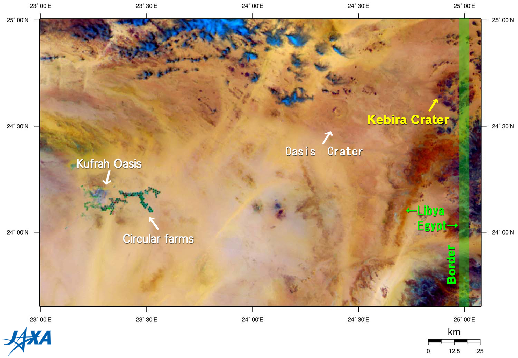
| Fig. 1 Sahara Desert near the Border of Libya and Egypt |
Large topographic structures on the Earth may escape recognition from the ground but are sometimes spotted in satellite images. Many meteorite impact craters might be typical of such cases. Researchers from Boston University recently found a large circular topographic structure in the desert area on the border of Libya and Egypt while investigating satellite images. Figure 1 is a reprint of the C region image from this " Seen from Earth; Circular Farms and Impact Craters in the Sahara" issued on November 12, 2004, which clearly captures this circular structure in the upper right. It has bold features, but no one noticed it until recently.
 |
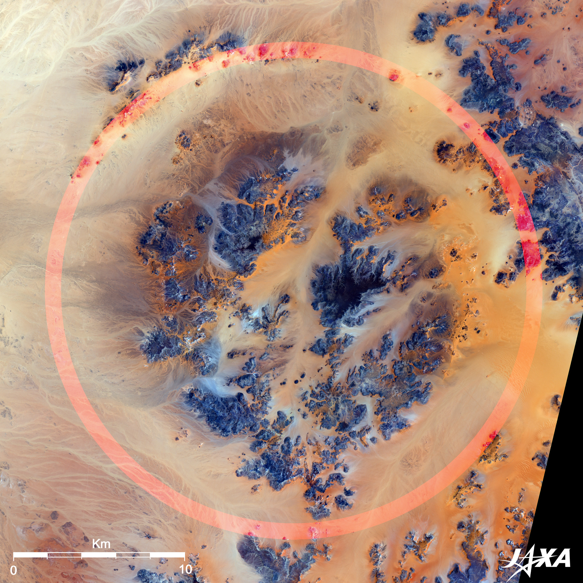
Fig. 2 Topographic Structure named Kebira Crater
Kebira Crater (kmz, 4.36MB, Low Resolution) as seen on Google Earth
(Full Image) |
Figure 2 is a close-up of this structure as observed by Daichi in July 2007. Although water and wind erosion marred the shape of the structure, a whitish circular sandy area surrounding the dark-brown central uplift can be recognized. A partially remaining outer rim (indicated by red circle) surrounds it. The outer rim was almost obscured by wadi and wind erosion but retains its overall circular pattern. The central uplift is also generally ring-shaped. The double-ringed structure bears the impression of a meteorite impact similar to structures frequently seen on the Moon and Mars. The outer rim is approximately 31km in diameter, which is about twice the size of the Sahara's current largest Oasis Crater in Libya (18km in diameter; also visible in Fig. 1), and more than 25 times the size of Arizona's famous Barringer Meteor Crater. Researchers from Boston University suspected that this might be a newly found meteorite impact crater and announced their discovery on March 3, 2006. The crater was named Kebira, meaning "large" in Arabic. The news of this discovery circled the world at that time. The intruder (meteorite or comet) is estimated to have been about 1.2km in diameter, and the energy released was equivalent to a nuclear explosion of more than 100,000 megatons. The impact would have wreaked devastation for hundreds of kilometers. The date of the impact is not known exactly, but the geological features of this area indicate that it may have been formed tens of millions of years ago.*1
Researchers from Boston University were, in fact, examining satellite images and looking for meteorite impacts , which may have created the mysterious glass fragments known as the Libyan Desert Glass (LDG). LDGs are yellow-green glass chunks, sometimes as large as a football, which were found on the desert surface between the giant dunes in southwestern Egypt and Libya. Since their discovery in 1932, their origin has long been a mystery. The famous Tutankhamun's Pectoral found in his anthropoid is decorated with an LDG scarab (an icon of a beetle that ancient Egyptians carried as an amulet). LDG is an amorphous glass of silicon dioxide (SiO2) with 98% purity, which can be heated up to 1,700°C before it begins to melt. The composition and structure of LDG is consistent with the scenario that it was formed from melted sand including silica, and then cooled slowly in the atmosphere.
Some samples are rich in iridium,*2 which is very rare on Earth but is typical of extra-terrestrial bodies such as meteorites or comets. All these characteristics of LDG indicate a meteor impact origin whose enormous heat melted sand and mixed iridium. However, there was no known impact site in the immediate area in which the LDG could have been created. Kebira Crater may be an important candidate for solving this mystery.
About the time of this discovery, a party of German geologists explored this area and found eroded table mountains of Carboniferous (345 million - 280 million years old) strata of sedimentary sandstone, which was similar to the Gilf Kebir (Great Barrier in southwest Egypt) plateau just south. The central uplift was also eroded and fissured, but undisturbed, uniform horizontal layers of sedimentary rocks were clearly visible. The jumbled, chaotic rock formations expected from meteorite impacts were not evident. The German geologists stated that the circular shape appears to be a pure coincidence and the whole formation could be the result of drainage pattern and subsequent eolian erosion.
There are many impact crater-like circular structures in the Gilf Kebir region. A team led by an Italian astronomer carried out a geologic expedition in this area and suggested a hydrothermal*3 origin.
The jury is still out on whether Kebira Crater is in fact a meteorite impact crater. The mystery seems to thicken about the Kebira Crater origin. Further in situ interdisciplinary investigation must be conducted in order to test the impact hypothesis.
*1 LDG has been dated at about 28.5 million years old using fission-track dating.
*2 The most probable cause of the dinosaur mass extinction is said to be the impact of an asteroid (10km in diameter) in the Yucatan Peninsula of Mexico 65 million years ago. The impact site is currently known as Chicxulub Crater estimated to be 160 to 240km wide. Celestial bodies such as meteorites are rich in iridium, which is rare on the Earth's surface. In 1980, Luis Alvarez and his son Walter Alvarez first proposed the asteroid impact theory, which is linked to the extinction event at the end of Cretaceous period. Alvarez found a sudden increase of iridium levels in rock stratum between Cretaceous and the following Tertiary periods (K-T boundary), recorded around the world, which provided direct evidence of the impact.
*3 The process through which sea water permeates into the earth, is warmed by the heat of magma or eruptive rock, and reacts with the rocks it contacted. |
Explanation of the images:
Fig. 1, Click figure to enlarge.
This special color composition was made by using GLI 250m resolution channels, and assigning red to the mid-infrared channel 29 (2,210nm), green to the near-infrared channel 23 (825nm), and blue to the visible channel 21 (545nm). In this image, clouds are white or light-blue, soil is brownish, vegetation is green, and water surfaces are black.
Fig. 2, Click figure to enlarge.
AVNIR-2 is equipped with a pointing function by which it can shift its observation area perpendicular to ALOS's direction of travel and has four observation bands. The composite images are produced by assigning red to Band 4 (760 to 890nm), green to Band 2 (520 to 600nm), and blue to Band 1 (420 to 500nm). In this image, deserts are light-brown, and rocks are dark-blue or dark-brown. |
|