| |
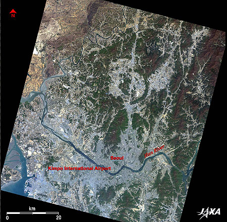 |
| Fig. 1 Seoul and Vicinity |
Figure 1 depicts Seoul and its vicinity as observed in April 2007. Seoul, the capital of the Republic of Korea, has developed on the banks of the Han (-Gang) River. The Han River originates in the Taebaek Mountain Range about 140km east of Seoul, passes through a steep gorge in the Korean Peninsula, and reduces its flow where Seoul is located. Seoul, referred to as "The Historic City Nestled in Mountains and Rivers," emerges from the satellite image. The light grey area in the lower middle of the figure is the Seoul urban area. The city area developed in the basin surrounded by mountains is considered to occupy an ideal location based on feng shui principles, an ancient Chinese custom. The big Han River flows through the center of the city from east to west. More than 1km wide, the river in the city area reveals the large extent of the flow passage area.
Kimpo International Airport is located about 30km west from the center of Seoul. As seen from the figure, the runway extends from southeast to northwest. Many runways of Japanese airports also extend in the same direction. This arrangement is advantageous in the strong northwesterly monsoon conditions in winter in far-east Asia (including the Korean Peninsula and Japan). International airlines were moved to Incheon International Airport, about 50km west of Seoul (not included in Fig. 1) in 2001. Kimpo Airport is thus now used for domestic services except for the Kimpo-Haneda route for Japan.
 |
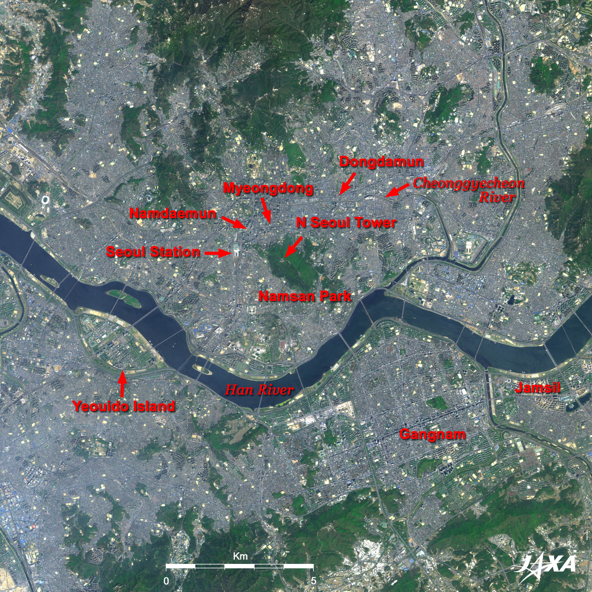
Fig. 2 Close-up of Central Seoul
Seoul (kmz, 2.26MB, Low Resolution) as seen on Google Earth |
Figure 2 is a close-up of central Seoul. Seoul is connected by many bridges spanning the Han River. On the north side of the river is the old city area of Gangbuk, and on the south side is the newly developed area Gangnam. The green hill in the center of the figure is Namsan Park, where the symbolic N Seoul Tower is located. To its west is the refurbished Seoul Station of KTX (Korea Train Express), which was launched for service in 2004. North of the station is the area most popular to the Japanese tourists, which includes the Myeongdong downtown area of central Seoul, Namdaemun front gate of the capital of the Korean dynasty, and Dongdaemun, one of the four great gates of Seoul. The streak running east and west between the north of Myeongdong and Dongdamun is the Cheonggyecheon River. Cheonggyecheon was underdrained in the late 1950s, and an elevated road, which supported economic growth of Korea, was built in the late 1960s. However, aging of the infrastructure posed a problem, and removal of the elevated road and restoration of the river were performed from July 2003 to September 2005, ignited by the Seoul mayoral election in 2002. It has now been converted to a place of recreation and relaxation of citizens.
The business area of Yeoido Island, including the Diet Building and broadcasting stations, and Jamsil area, including Lotte World, the world's largest indoor amusement complex (twice as large as Tokyo Dome), are visible on the south side of the river.
A significant feature of the city, not very far from the city center, is the regularly lined up cluster of many rectangular buildings. Most of them are multistory apartment building complexes. The most typical one is a huge apartment complex in Gangnam area on the south bank of the Han River.
The image was captured in late April. The plants which endured cold and dry winter in Seoul suddenly sprout together, and a clear green area emerges in the satellite imagery like an island in the ocean of the big city.
Explanation of the Image:
Figs. 1 and 2 (Click the images twice to enlarge them.)
AVNIR-2 has four observation bands. The composite images are produced by assigning red to Band 3 (610 to 690nm), green to Band 2 (520 to 600nm), and blue to Band 1 (420 to 500nm). The resulting image has natural coloring as if seen by the naked eye. In the above figures, green is assigned to the sum of 90% of Band 2 and 10% of Band 4 (760 to 890nm), which improves the visibility of vegetation. Thus, the ground objects are distinguished by the following colors.
| Dark green: |
Forests |
| Light green: |
Grass fields, farmlands |
| Bluish grey: |
City area, roads |
| Light brown: |
Bare ground, buildings |
| Blue: |
Water surfaces |
|
 |
|