| |
 |
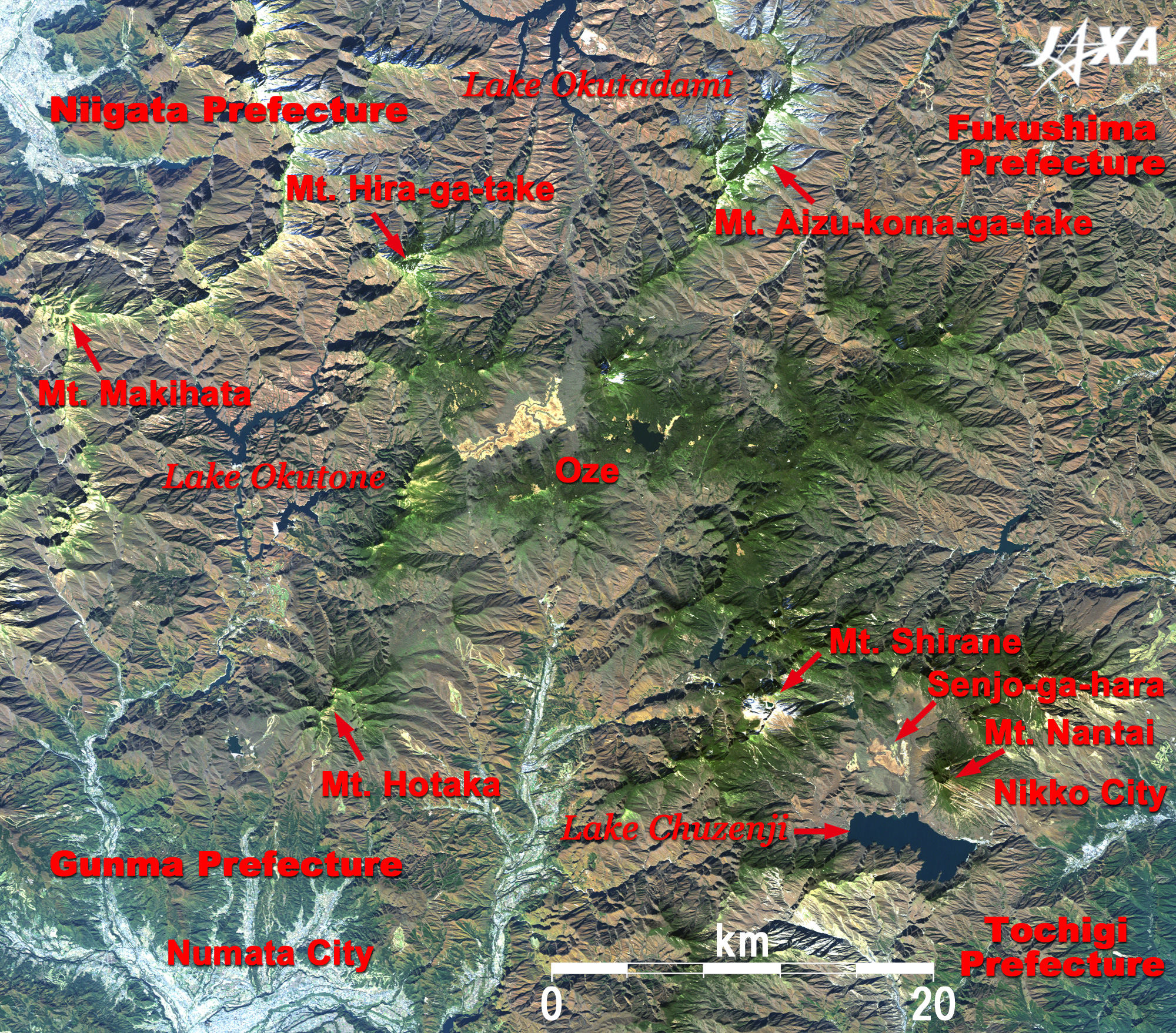
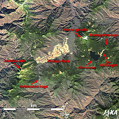
Fig. 1 Vicinity of Oze National Park
Oze (kmz, 5.24MB, Low Resolution) as seen on Google Earth.
(Full Image) |
Figure 1 depicts the vicinity of Japan's new Oze National Park as observed in early November 2006. Oze National Park (37,000ha), which opened on August 30, separates the Oze area from Nikko National Park and is shown together with the adjacent Aizukoma-ga-take and Taishaku-san (-take, -san, and -yama mean mountain) areas, which have similar landscape and flora. This is the first separation of a national park and the first new national park to be designated in the past two decades since Kushiro Shitsugen (wetland) National Park. The upper left of the figure depicts Niigata Prefecture. The mountain ridge to its east is Echigo Range, where the rugged peaks of Makihata-yama, Hira-ga-take, and Aizu-koma-ga-take stand in a row. The light-grey area in the lower left of the figure is Numata City, Gunma Prefecture, and Hotaka-yama rises high to its north. The urban area in the lower right is Nikko City, Tochigi Prefecture, and the little snowcapped mountain to its west is Shirane-san, the highest peak (2,578m) of the Nikko Range of the Nikko National Park. Chuzenji-ko (-ko or -numa means lake) is just below Nantai-san at the opposite right side of Senjo-ga-hara (-hara means grassland). The light brown area, surrounded by 2,000m mountains and nestled quietly in the basin on the borders of Fukushima, Gunma, and Niigata Prefectures, is Oze. The satellite image reveals that it is located in a remote mountainous area. Similar to bird's footprint shape, Japan's leading man-made lakes such as Okutadami-ko and Okutone-ko are visible in the gorges between the mountains. Bountiful precipitation in this area has created a natural treasury of precious ecosystems.
 |
 |
| Late June, 2006. |
Early November, 2006. |
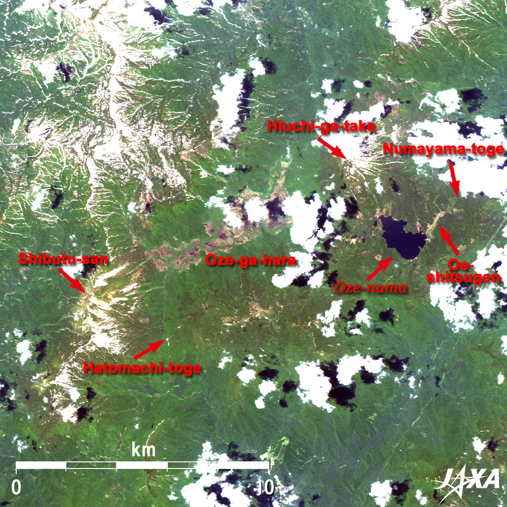
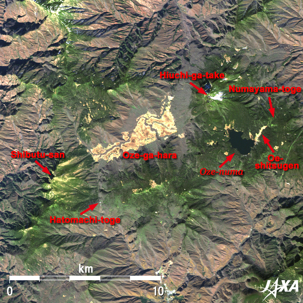
| Fig. 2 Close-up of Oze and Vicinity |
Figure 2 presents close-ups of Oze and its vicinity in summer and autumn. The lake visible in the center right is Oze-numa (180ha). The water of Oze-numa (1,665m) flows into Oze-ga-hara (1,400m) at the center of the figure, and forms the largest high moor (760ha) on Honshu (main) Island of Japan. There are about 300 Chito (small high-moor ponds) of various sizes in Oze-ga-hara, which makes the satellite imagery of this marshland appear mottled. The two dominant mountains on the east and the west of the Oze-ga-hara are Hiuchi-ga-take (2,356m) and Shibutsu-san (2,228m). These two symbolic mountains of Oze serve as a backdrop for the scenery and provide observatories for grand views. , There is a unique rich flora of Oze from the difference of geological origin.
Oze's trail has well-maintained board walks that are easy to walk and displays seasonally changing faces of nature, attracting more than 300 thousand hikers both old and young alike each year. The main starting points of the trail are Hatomachi-toge (mountain pass) near Oze-ga-hara, and Numayama-toge near Oze-numa. In the spring, thaw water moistens the marshland and white Mizu-basho (giant skunk cabbage) flowers, the symbol of Oze, blossom in mid-May. When summer comes, Oze-ga-hara is transformed to green with surrounding mountains like the left image of Fig. 2. White watasuge (cotton grass) flowers and the lovely rose pink or lavender color of alpine flora rustling in the wind encourage hikers to stop for a while and rest. The Oe-shitsugen (marshland) that extends from Oze-numa to Numayama-toge is famous for a large colony of nikko-kisge (yellow alpine lilies). The song "Remembrance of Summer," which starts with the phrase "I remember when summer comes..." is an excellent piece of music that praises the beautiful Oze of summer. The song is loved by the whole country.
Autumn comes to Oze in September. The marshland then changes color in harmony with the autumn tint of the surrounding mountains. The right image in Fig. 2 captures the marshland grass shining gold in the light of the autumn sun. The narrow lines that divide Oze-ga-hara are the courses of rivers in the marshland. Oze in winter turns into a silvery landscape and conceals everything in deep snow until the next spring.
Oze was designated a special conservation area as a part of Nikko National Park in 1953, and added to the List of Wetlands of International Importance of the Ramsar Convention in 2005. Nature conservation movements have been launched in grass-roots campaigns whenever power plant or sightseeing road development projects emerged as issues, and valuable nature has been protected until today. Oze is known as the birthplace of the "Take-garbage-home movement," where the conservation movement embodying the symbiosis of man and nature began in Japan.
Explanation of the Images:
(Figs. 1, 2 and the full image; Click the image twice to enlarge it.)
AVNIR-2 has four observation bands. The composite images are produced by assigning red to Band 3 (610 to 690nm), green to Band 2 (520 to 600nm), and blue to Band 1 (420 to 500nm). The resulting image has natural coloring as if seen by the naked eye. Thus, the following colors designate ground objects.
| Green: |
Forests |
| Brown: |
Tinted autumn forests |
| Light brown: |
High moor |
| Bluish grey: |
City area, roads |
| Blue: |
Water surfaces |
| White: |
Clouds, snow |
|
 |
|