| |
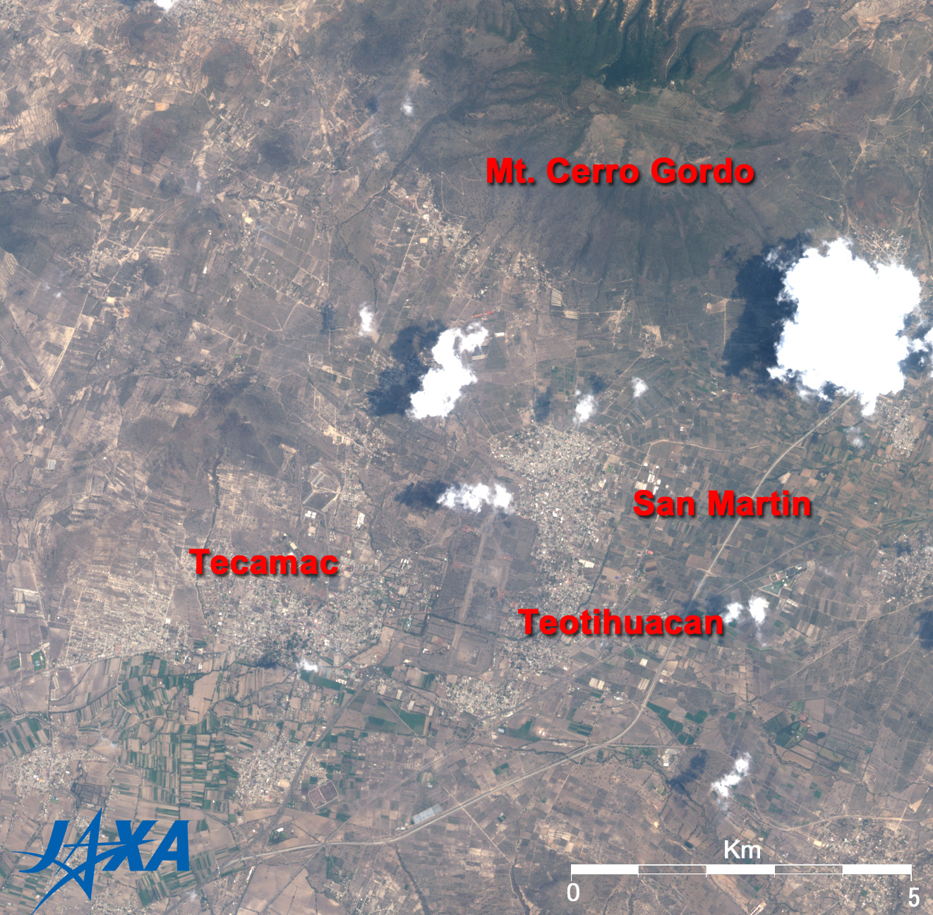
Figure 1 depicts ancient Teotihuacan and its vicinity in the United Mexican States as acquired in May 2007. Teotihuacan flourished from the second century BC to the sixth century AD and was the largest city on the American continent, comparable with ancient Athens in Greece, Chang'an in the Tang Dynasty, and Constantinople in Byzantine. The city covered 20km2 and probably housed a population of 200,000. Teotihuacan is located 2,300m above sea level and in a basin 50km northeast of Mexico City, the capital of the United Mexican States. Teotihuacan may suddenly appear in front of you after you drive one hour from Mexico City on the desert covered with cactuses. The completely abandoned ruin of the city was found by Aztecs in 12 century. The Aztecs built their city on the current site of Mexico City and worshiped the ruins for a long time as a place where Gods lived. The Cerro Gordo Volcano is visible on the north side; it had no small influence on the building of the city.
 |
Fig. 2 Teotihuacan
Teotihuacan (kmz, 1.53MB, Low Resolution) is seen from Google Earth. |
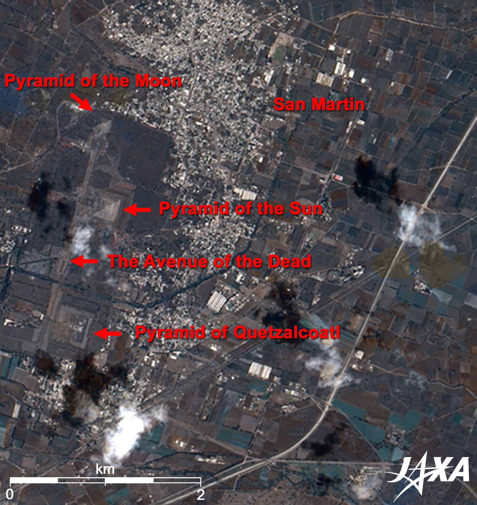
Figure 2 is a pan-sharpened close-up image of Teotihuacan composed of the images acquired in September 2006 and Fig. 1. The historic spots in Teotihuacan are the pyramid of the Moon (47m high; 140m by 150m base) at the north end, the 2.5km-long and 40m-wide Avenue of the Dead running from north to south, the pyramid of the Sun along the street, the Citadel, the palace of Quetzalcoatl, and so on. The pyramid of the Sun is 65m high with a 222m by 225m base and is the third highest pyramid in the world. The pyramid of the Moon is 18m lower than the pyramid of the Sun, but it is located on a 13m hill so their summits are almost the same height. This relation is a similar to the Great Pyramid and Khafre Pyramid of Egypt.
The Avenue of the Dead is offset 15.5 degrees east from the cardinal points. There are numerous opinions of why the Teotihuacan people offset the center line of the Avenue but built the large city in order, but it was intentional. Some believe that this Avenue was a huge pool. Many temples in Teotihuacan were dedicated to praying for rain. It may be practical reasons for an ancient people to build a water reservoir in the desert.
The Citadel is surrounded by large, thick wall 7m in height and 45m wide at the south end of the Avenue. It was named by the Spanish, but its purpose is unclear. It encloses the pyramid of the Quetzalcoatl. This pyramid is valuable to archeology as ancient American ruins because it is well preserved and contains colorful paintings. It is 22m high and was built using the Talud-Tablero building technique. It is an example of the unique Teotihuacan architecture and is faced with many head statues of Quetzalcoatl, the feathered serpent god for agriculture, and Tlaloc, the god of rain and fertility. Quetzal means bird and Coatl means snake. The pyramids of the Sun and the Moon were named by the Aztecs from their myths. No one knows what the Teotihuacan called their building and statues. The Avenue of the Death was also named by the Aztecs in the mistaken belief that they thought the small hills along both sides of the Avenue were graves (actually, they are ruins of temples).
Teotihuacan is literally the City of Gods. The great mysteries are who built it, what is the purpose and where did the builders go. Recent excavations have revealed that they had advanced astronomy and a rich lifestyle. "Pre-Hispanic City of Teotihuacan" was added to the list of the World Heritage of the United Nations Educational, Scientific and Cultural Organization (UNESCO) in 1987.
Explanation of the Images:
Figs. 1 and 2, Full Image. Click the image twice to enlarge it.
PRISM is an optical sensor for observing ground surfaces with visible and near-infrared signals in the 520 to 770 nano-meter (one-billionth of a meter) band. The acquired image is monochrome. PRISM has three independent optical systems (telescopes) to acquire images for nadir, forward, and backward views at the same time. Only the nadir image was used in this article.
AVNIR-2 is equipped with a pointing function by which it can shift its observation area perpendicular to ALOS's direction of travel and has four observation bands. The composite images are usually produced by assigning red to Band 3 (610 to 690nm), green to Band 2 (520 to 600nm), and blue to Band 1 (420 to 500nm). The AVNIR-2 composite image was then transformed into hue, saturation and intensity, and the intensity was replaced by the PRISM image. The hue, saturation and intensity data were then reversed into a color image. As a result, a virtual 2.5m ground-resolution color image was obtained. This kind of high-resolution color image, composed by combining the higher-resolution monochrome image and the lower-resolution color image, is called a pan-sharpened image.
Figure 2 depicts high-resolution, pan-sharpened images composed this way. The resulting image has natural coloring as if seen by the naked eye. Thus the following colors represent ground objects.
| Ocher or brown: |
Bare ground or farm land |
| Green: |
Farmland or forests |
| Grey: |
City area or roads |
| Red: |
Roofs of houses |
| White: |
Clouds |
| Black: |
No data |
|
 |
|