ページの先頭です。
本文へジャンプする。
【Important Notices】This page is an archive page of information published in the past. Since the update has been completed, it may contain broken links or outdated information. For the latest information, please use the new site Earth-graphy (earth.jaxa.jp).
ここからサイト内共通メニューです。
サイト内共通メニューを読み飛ばす。
サイト内共通メニューここまで。
ここから本文です。

Seen from Space 2007

Baikonur Cosmodrome - Launch site of the world's first artificial satellite

 
Fig. 1 Baikonur Cosmodrome Seen from Space
In 1957, some fifty years ago, the world's first artificial satellite, Suptnik-1, was launched from Baikonur Cosmodrome. Since the launch, the Cosmodrome has been one of the stages of the space race between the USA and the USSR, and it is still pushing the human frontier further into space.
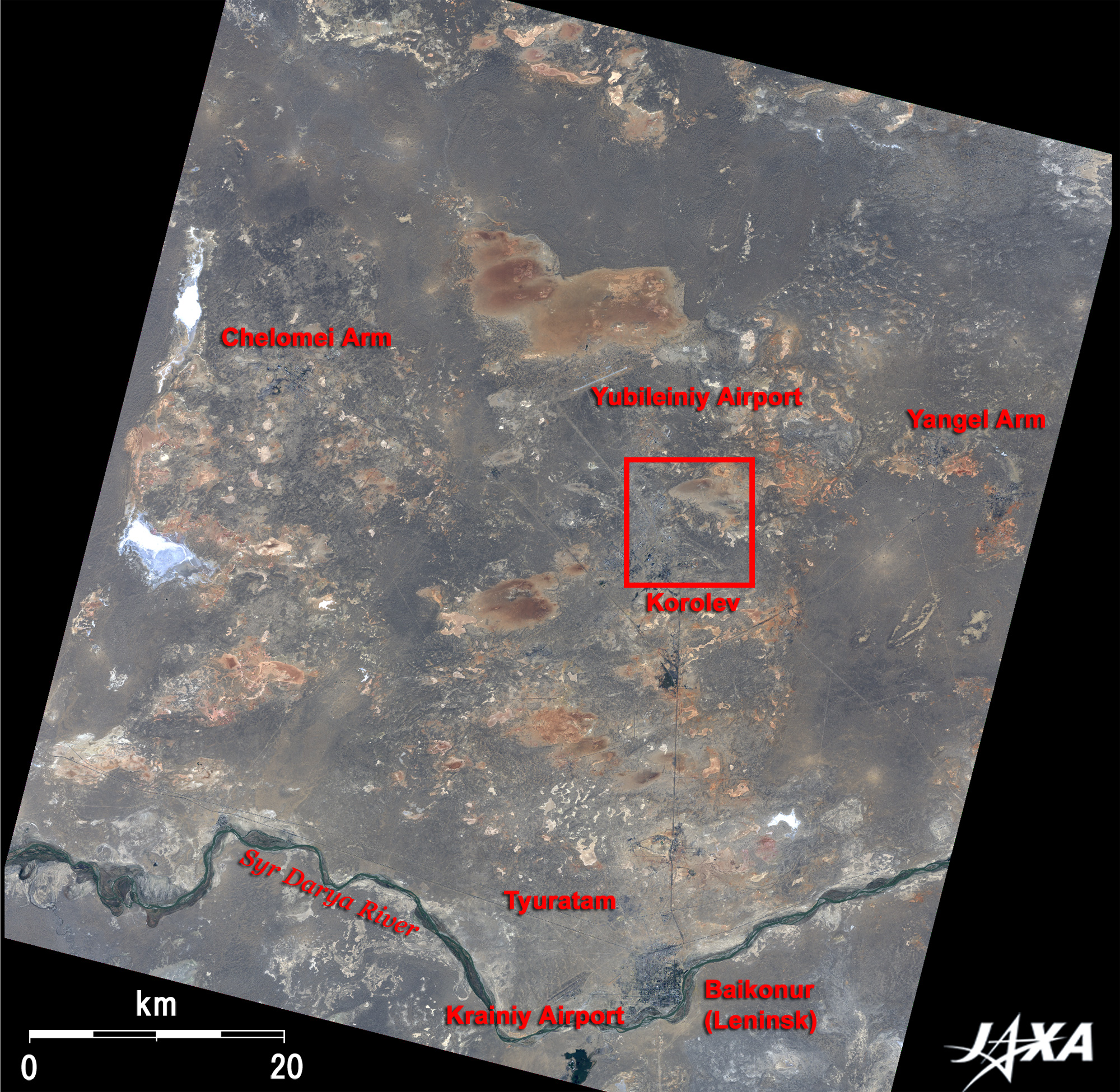
Figure 1 depicts Baikonur Cosmodrome as of September 2006. There are vast expanses of semi-arid zones in Central Asia, where layers of bluish gray heavy clay, reddish brown sandy soil, and some white sprinkled salty lakes are seen.
The Syr-Darya River can be seen in the south of the image, flowing from its source in the Tian Shan Mountains, tending down to the northwest or west, and flowing into the Aral Sea. A railway runs on the right bank of the river. Around Baikonur station, the center of living and culture, the town of Baikonur (Leninsk renamed in 1995) is seen in dark blue.
The railway extends north from Baikonur and branches right and left into Baikonur Cosmodrome. The Cosmodrome extends from Baikonur in the south to Yubileiniy Airport in the north and is composed of three areas. From Baikonur, these are the "Korolev" area located 30km north, "Chelomei" area located in 70km north-west, and "Yangel" area located in 50km north-east. Chelomei contains facilities such as launch complexes for the Proton rockets that have launched some modules of the International Space Station (ISS), the middle-class Tsiklon rockets. Korolev's facilities include the test launch complex for Soyuz rockets. Yangel contains launch complexes for the Soyuz rockets in the operational phase, the Zenit rockets, the Dnepr rockets, and so on.
The Cosmodrome is located in Tyuratam, in the Republic of Kazakhstan, about 2,100km south-east of Moscow, Russia, and east of the Aral Sea. Its annual mean temperature is 13°C. In the summer it is dry, and the temperature rises to 45°C, but in the winter it is frosty, windy, and a little rainy with the temperature dropping to -40°C, in the severe typical continental climate.
The total area of Baikonur Cosmodrome is about 5,000 km2, almost the size of Chiba Prefecture. There are nine launch complexes and 15 launch pads as well as other facilities. The Cosmodrome is rented by the Russian Federal Space Agency (FSA, Roskosmos) from the Republic of Kazakhstan after its independence in 1991.

Fig. 2 Enlarged image of the central area of Baikonur Cosmodrome
Baikonur (kmz, 1.45MB, Low Resolution) is seen from Google Earth.
In the enlarged image of the central area of Baikonur Cosmodrome of Fig. 2, some facilities linked by railway can be seen in the south and west. In the south, there is a railway with two curved branches. At the end of the southern branch are facilities for Soyuz rockets including the launch pad, Site 1, and the assembly building, Site 2, which were built originally in 1955 with the construction of the Cosmodrome. The world's first artificial satellite, Sputnik-1, was launched from this launch pad on October 4, 1957. On April 12, 1961, Vostok-1 was launched from the launch pad, lifting cosmonaut Yuri Gagarin into space, marking the first manned space flight in the history of human beings.
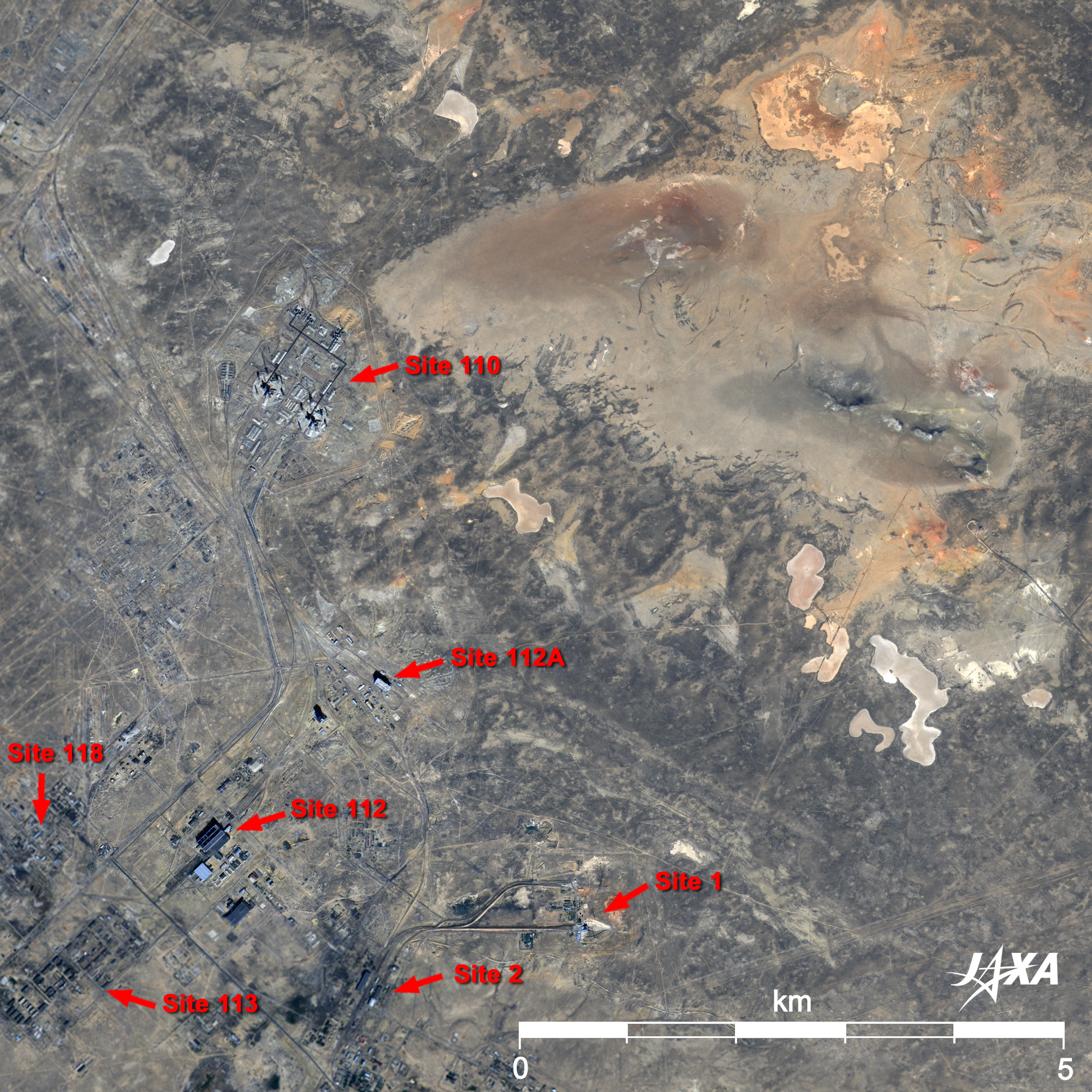
With passing time, the Cosmodrome has been expanded, and many lunar explorers, meteorological satellites, military satellites, commercial communications satellites, and manned space ships have been launched from it. On December 2, 1990, a correspondent from Tokyo Broadcasting System, Inc. (TBS), Mr. Toyohiro Akiyama aboard the space ship Soyuz TM-11 was launched by a Soyuz rocket, and on August 24, 2005, JAXA's two satellites, Optical Inter-orbit Communications Engineering Test Satellite "KIRARI" (OICETS) and INovative-technology Demonstration Experiment "REIMEI" (INDEX) were launched piggyback by a Dnepr rocket.
The two facilities standing apart from others in the west in Fig. 2 comprise Site 110 for launching the super-heavy booster Energia, which can carry a 100-ton payload into low-Earth orbit. The area south of Site 110 holds many facilities such as Sites 112 and 112A comprising the assembly and fueling station, and Sites 113 and 118, comprising the residential and storage areas. On November 15, 1988, an Energia carrying an unmanned Buran reusable shuttle blasted off from Site 110 left, and two orbits later the Buran automatically landed at Yubileiniy airport.
As a stage of daring challenges to realize the expansion of the frontier of human activities, and as an important point linking Earth and space, even further progress is expected.


Reference Site:
Encyclopedia Astronautica, Baikonur
RussianSpaceWeb.com, CENTERS: Baikonur

Explanation of the Image:
Figs. 1, 2
Satellite: Advanced Land-Observing Satellite (ALOS) (Daichi)
Sensor: Advanced Visible and Near Infrared Radiometer-2 (AVNIR-2) , Panchromatic Remote-sensing Instrument for Stereo Mapping (PRISM)
Date: 0649 (UTC) on September 1, 2006
Ground resolution: 10m (AVNIR-2), 2.5m (PRISM)
Map Projection: Universal Transversal Mercator (UTM)
AVNIR-2 has a pointing mechanism to change the field of view in the cross-track direction and four observation bands. Figure 1 was composed by assigning red to visible Band 3 (610 to 690nm), green to visible Band 2 (520 to 600nm), and blue to visible Band 1 (420 to 500nm). The resulting image has natural coloring as if seen by the naked eye.
In these images, sandy soil is reddish brown, layers of heavy clay are bluish gray, urban districts and roads are dark blue, salty lakes are white, and water bodies are black. Areas with no data are also black.
PRISM is an optical sensor for observing ground surfaces with visible and near-infrared signals in the 520 to 770 nano-meter (one-billionth of a meter) band. The acquired image is monochrome. PRISM simultaneously acquires images for nadir, forward, and backward views.
The AVNIR-2 composite image was transformed into hue, saturation and intensity, and the intensity was replaced by the PRISM image. The hue, saturation and intensity data were then reversed into a color image. As a result, a virtual 2.5m ground-resolution color image was obtained. This kind of high-resolution color image, composed by combining a higher-resolution monochrome image and a lower-resolution color image, is called a pan-sharpened image.
Figure 2 is a high-resolution pan-sharpened image composed this way.

Reference Sites:
ALOS Research and Application Project
Tanegashima Island observed by the Advanced Visible and Near Infrared Radiometer type-2 (AVNIR-2) aboard the ALOS
Land, Seen from Space
本文ここまで。
image:Satellite Navigator
image:Satellite Applications and Operations Center(SAOC)
Earth Data Collection by JAXA Satellites
image:ページTOP