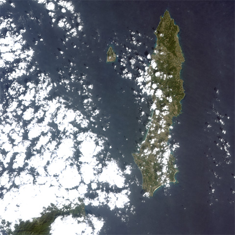
Fig.1: Tanegashima Island in Kagoshima Prefecture observed by the AVNIR-2 aboard the ALOS.
(Click to View Enlarged Image)
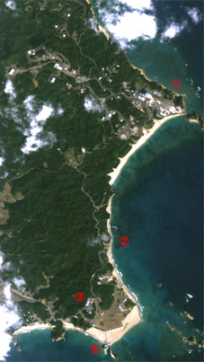
1.Yoshinobu Launch (H-II) Complex 2.Tanegashima Lighthouse 3.Range Control Center 4.Takesaki Observation Deck
Fig.2: The area of Tanegashima Island was enlarged
(Click to View Enlarged Image)
>
Tanegahima Island observed by the AVNIR-2 (Movie)
(12.8MB, To view movie, you need "Macromedia Flash Player" on your computer.)
The diagram is image data on Tanegashima Island in Kagoshima Prefecture observed by the Advanced Visible and Near Infrared Radiometer type-2 (AVNIR-2) onboard the Advanced Land Observing Satellite "Daichi" during the day time (around 10:50 a.m.) on February 17, 2006 (JST). The color of the image is close to what the human eye can see, and the spatial resolution is 10 meters. For example, you can identify sand beaches and shallows along the seashores, vegetation and buildings. The Takesaki Observation Deck in Minami-tane cho and the Yoshinobu Launch (H-II) Complex from which the H-IIA Launch Vehicle will be launched are also clearly seen. By combining information of four observation bands from visible light to near infrared light, we can learn the health of agricultural products and forests, land usage, and local environmental conditions.
Note: Spatial resolution indicates the physical size of an object that can be distinguished in an image.
©JAXA EORC
Copyright©1997- JAXA EORC All rights reserved.