| |
Figure 1 is a satellite image of the area around the Japanese Syowa Station in Antarctica taken this February (2007). The Ongul Islands, where Syowa Station is located, appear dark brown in the lower right, and countless mysterious shadows cover the whole figure.
It seems that the rime on trees was exposed to the setting sun, and countless long shadows were formed. However, there are no trees because Syowa Station is surrounded by the sea. If you zoom in, you will find that the shadows are caused by countless icebergs and exposed rocks. Table-shape icebergs are being born in the top right corner of the figure.
Next, let's think about the shadows. The directions of the shades look almost correct because the sun's azimuth (you measure clockwise from the north as 0°) was 54° and the elevation was 30° at that time. However, some shadows are up to 4km long. In that case, the icebergs causing the shadows would have to be an unbelievable 2.3km high. Additionally, if you look closely, you will find that the shadow directions are somewhat different between the lower right corner and the upper left corner of the figure. This suggests that these shadows are not produced by sunlight.
Look at the expanded image of the figure again. The shaded areas look like the sea-ice surface where snow hasn't piled up. It seems reasonable to think that these shadows indicate areas where snow was blocked by icebergs and couldn't accumulate.
The wake of Japan's Antarctic exploration ship "Sirase" appears as white or black lines at the bottom of the figure and on the east side of Ongul Islands.
If you view the figure upside-down, you will have a different impression from the original due to an illusion. This is because we are usually familiar with scenery lit from above by sunlight. This image looks the back of the porcupine or some kind of explosion at the far bottom of the figure. Images lit from below can make us feel anxious.
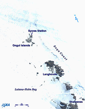 |
| Fig. 2 Map of Syowa Station |
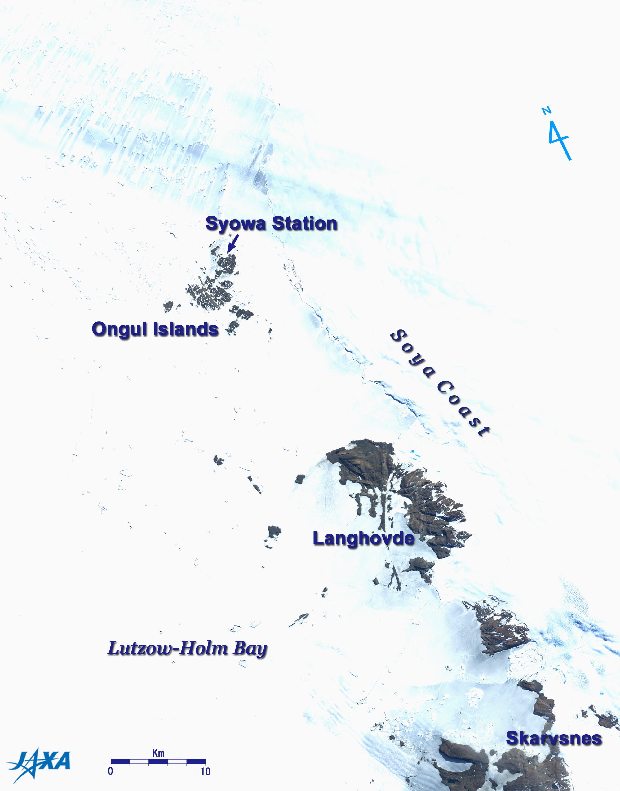
Figure 2 depicts a satellite image of the Syowa Station vicinity taken this January (2007). Thin clouds hang over the north side of Syowa Station. The dark brown areas indicate places where rocks are exposed. Almost all areas are covered with snow, and it is impossible to distinguish the land from the sea.
Syowa Station was constructed on East Ongul Island, one of the Ongul Islands in Lutzow-Holm Bay in Antarctica. Soya Coast, which is the part of Antarctica, stretches east of the Ongul Islands. Langhovde and Skarvsnes south of the Ongul Islands are peninsulas with rock-exposed areas.
Syowa Station was established on January 29, 1957, exactly 50 years ago, when the first Japanese Antarctica Research Expedition team, which left Japan in the previous year, approached Antarctica in exploration ship "Soya," landed on East Ongul Island, and named the entire nearby area "Syowa Station." This project was implemented to participate in the international scientific research project, International Geophysical Year (IGY; July 1, 1957 - December 31, 1958) corresponding to the solar maximum period.
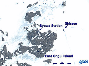 |
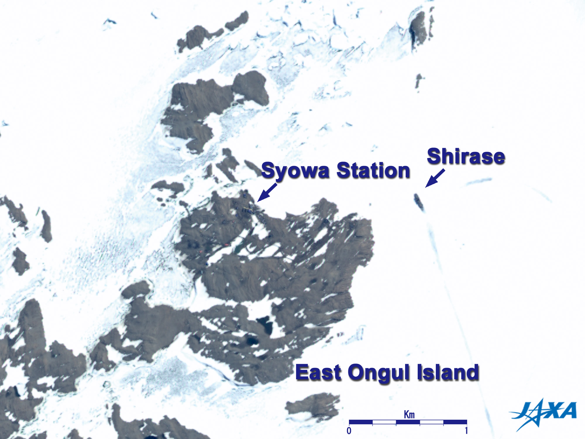
| Fig. 3 Syowa Station and Antarctic exploration ship Shirase (January 1, 2007) |
Figure 3 is a pan-sharpened image depicting Syowa Station and Shirase. Syowa Station is at the end of the arrow. You can see the dark-blue buildings linked by yellow aisles, the gray buildings on the southeastern side, and two buildings with red roofs which set a little apart on the southwestern side. Shirase was anchored about 1.5km east from Syowa Station, and goods were transported from here using snowmobiles, a helicopter, and a petroleum pipeline.
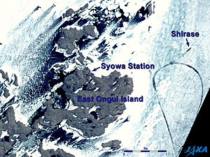 |
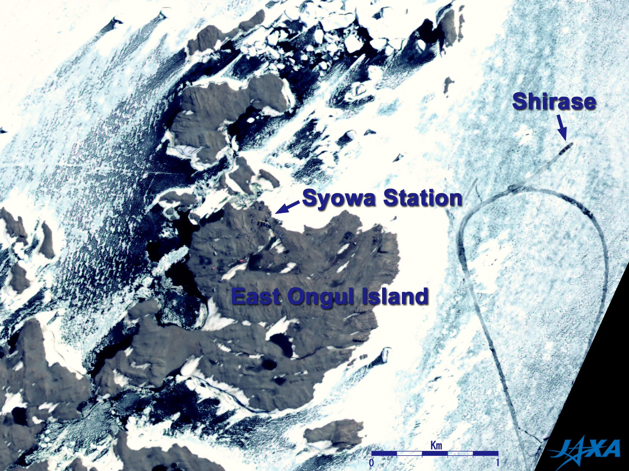
Fig. 4 Syowa Station and Antarctic exploration ship Shirase (February 4, 2007)
Syowa Station (kmz, 1.5MB, Low Resolution) is seen from Google Earth. |
Figure 4 indicates the same area as Fig. 3 but approximately one month later.
You can see that the position of Shirase changed.
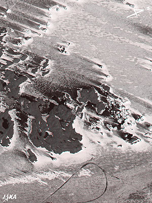 |
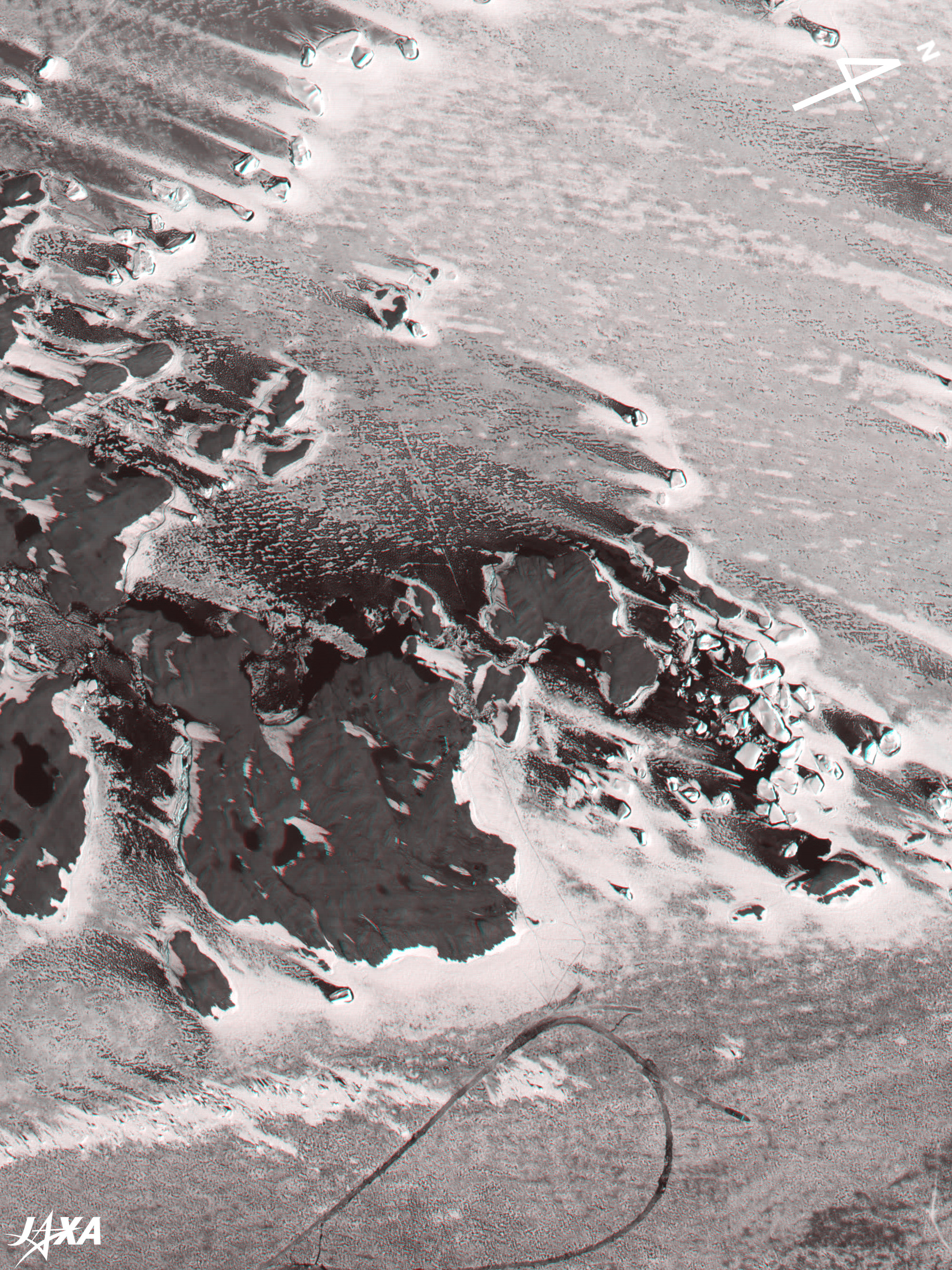
Fig. 5 Three-Dimensional View of Syowa Station and Antarctic exploration ship Shirase
(Staring at the image for a long time may cause eye-strain. A color print is available in pdf format. Pdf files for the left and right eyes are also available for stereoscopic viewing.) |
Figure 5 is a three-dimensional view of East Ongul Island including Syowa Station and Shirase. Note that upper right is north in this figure. If you view this figure with red and blue glasses, you can distinctly see the flat sea-ice surface, the icebergs pushing out from the sea-ice surface, Ongul Island, and the other islands rising up, and two ponds in southern East Ongul Island. There are also tracks of snowmobiles that had passed by.
References:
Kazuyo Sakanoi and Yoko Tohno, "Nankyoku ni kurasu - Nihon josei hatsu no ettou taiken --" (Living in Antarctica - Japanese women's first staying experience over winter) (in Japanese), Iwanami Shoten, 2000
Reference Site:
 How to make the red and blue colored glasses: See Appendix of Three-Dimensional View of Mt. Haruna How to make the red and blue colored glasses: See Appendix of Three-Dimensional View of Mt. Haruna |
Explanation of the Images:
Figs. 1 to 5
AVNIR-2 has four observation bands. Figures 1 and 2 were composed by assigning red to visible Band 3 (610 to 690nm), green to visible Band 2 (520 to 600nm), and blue to visible Band 1 (420 to 500nm). The resulting image has natural coloring as if seen by the naked eye. In these images, snow and clouds are white; exposed rocks, soil and sand are brownish; and the sea surface and sea-ice surface are blackish. Areas with no data are black.
PRISM is an optical sensor for observing ground surfaces with visible and near-infrared signals in the 520 to 770 nano-meter (one-billionth of a meter) band. The acquired image is monochrome. PRISM has three independent optical systems (telescopes) to acquire images for nadir, forward, and backward views at the same time so that terrain data including altitude data can be obtained.
Figures 3 and 4 were produced as follows. First, the image is color-composed as mentioned above, then transformed into hue, saturation and intensity components. The Intensity component was then replaced by the PRISM image. The hue, saturation and intensity data were then reversed into a color image. As a result, a virtual 2.5m ground-resolution color image was obtained. This kind of high-resolution color image, formed by combining the higher resolution monochrome image and the lower resolution color image, is called a pan-sharpened image. Figures 3 and 4 have the same coloring as Figs. 1 and 2.
Figure 5 was composed using the nadir image (red) and the forward image (green and blue). The left side is the satellite direction of travel because the nadir of the satellite is seen with the left eye and the forward direction with the right eye. The left side corresponds to the southwest. Note that the upper right side is north in Fig. 5.
|  |
Related Sites:
ALOS Research and Application Page
World's most beautiful city near Indian Ocean: Perth, Western Australia
Summer in the Antarctic
Cryosphere, Seen from Space
Appendix:General sailing schedule of Antarctic exploration ship Shirase
| November 14: |
Sails to Harumi Pier, Tokyo. |
| End of November: |
Stops at Fremantle, suburbs of Perth, Australia. |
| Beginning of December: |
Sails after taking on perishable foods and the expedition members who arrived by airplane. |
| End of December: |
Arrives at Syowa Station. Replenishing goods and constructing buildings. The summer team begins the expedition. The new winter-over team hands over from the previous winter-over team and prepares for staying over winter. |
| End of February: |
Sails to Syowa Station. |
| End of March: |
Arrives at Sydney, Australia. All expedition members disembark and return to Japan by airplane. |
| Middle of April: |
Returns to the Maritime Self-Defense Force Yokosuka Base. |
|
|