| |
 |
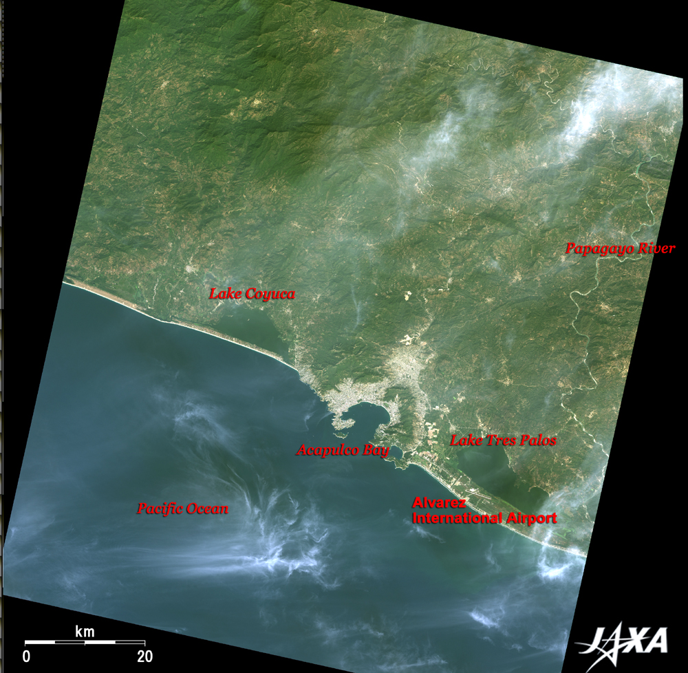
| Fig. 1 Acapulco and Its Vicinity |
Figure 1 depicts Acapulco of the United Mexican States (Spanish: Estados Unidos Mexicanos) and its vicinity as observed by the Advanced Visible and Near Infrared Radiometer-2 (AVNIR-2) on board the Advanced Land Observing Satellite (ALOS) "Daichi" in January 2007. Acapulco is a major beach resort in the state of Guerrero on the Pacific coast of Mexico, 300km (190 miles) southwest of Mexico City. Acapulco Bay (Bahía de Acapulco) is visible in the center of the figure. The large lakes on the sides of Acapulco Bay are Lake Coyuca (Laguna Coyuca) on the west (left) and Lake Tres Palos (Laguna Tres Palos) on the east (right). Alvarez International Airport is located to the south (lower right of the figure) of Lake Tres Palos. The Papagayo River (Rio Papagayo) meanders in the right of the figure. White, thin clouds are visible in the upper right of the figure and over the Pacific Ocean at the bottom.
Acapulco developed as a leading resort town after World War II following the tourism development plan of Mexico. People of North America welcomed Acapulco as a nearby stylish resort and an alternative to Hawaii, Cuba, and Europe. In particular, Cuba lost many foreign tourists after the Cuban Revolution in 1959, and Acapulco became the most popular resort instead.
 |
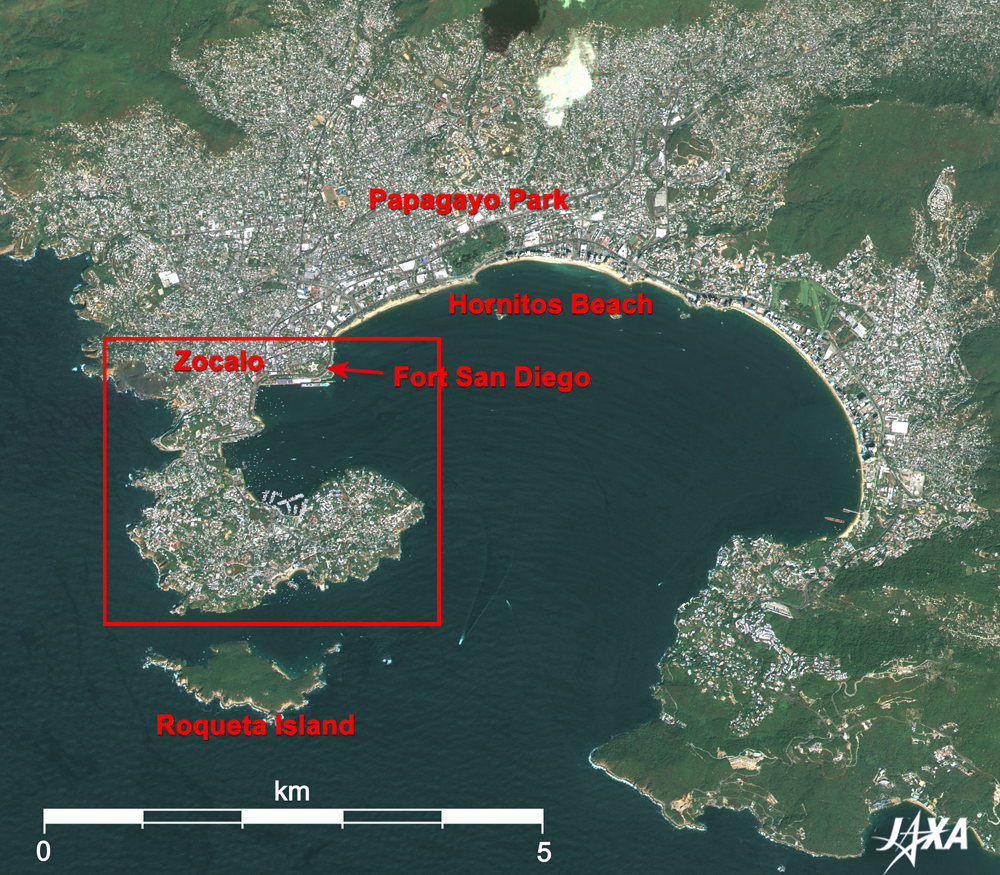
| Fig. 2 Close-up of Acapulco Bay |
Figure 2 is a pan-sharpened close-up image of Acapulco Bay and its vicinity. This figure was composed of the images acquired by the Panchromatic Remote-sensing Instrument for Stereo Mapping (PRISM) and AVNIR-2. A hook-shaped peninsula located on the west of the bay is mostly developed. In contrast, lush forests remain on Roqueta Island (Isla de la Roqueta) off the coast of the peninsula.
Zocalo, meaning a plaza in Spanish, at the base of the peninsula is the downtown (old city) area.
Papagayo Park (Parque Papagayo) is located along the beach 2km east from the base of the peninsula. Many tropical trees and flowers have been planted, and many kinds of wild birds can be found here. You can see the long shadows of high-rise hotels stretching several kilometers along the beach from the park. A ship with a long brown deck moored at the east end of the beach and many round oil tanks on the wide triangular ground to the northeast are visible. It indicates that the ship is an oil tanker. A bright green golf course is visible in the middle of the long beach, and to its southeast is located a water-oriented theme park for children called CiCi (Centro Internacional para Convivencia Infantil ), where facilities for dolphin and seal shows, a wave pool, a waterslide, a mini-aquarium, and other attractions are visible in light blue. These entertainment facilities make up this resort town and attract three million tourists each year.
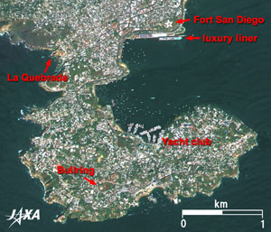 |
Fig. 3 Close-up of Old Acapulco
Acapulco (kmz,859KB,Low Resolution) is seen from Google Earth.
|
Looking closer at the image, you can see a long straight wharf running east and west at the base of the peninsula, where a large vessel was berthing. Two images used to create the pan-sharpened image were not acquired on the same day, but, by chance, a different vessel was berthing on each day. The vessel seen on October 8, 2006, was estimated to be 294m long; the other vessel observed on January 8, 2007, was estimated to be 270m long. It is not clear in this figure, but the bows of the vessels were pointed in opposite directions. The lengths of the vessels indicate that they were luxury liners.
Many small vessels are moored at the yacht club opposite the wharf. To its southwest, a bullring with a brownish stand around a white circular ground is visible inside the peninsula. One of the Acapulco's famous attractions, "La Quebrada Cliff Divers," is found here. Fearless divers perform impressive high dives into a narrow, rocky channel facing the Pacific Ocean at the west of the peninsula base, plunging into the churning ocean water below from a sheer cliff more than 40m-high. The pentacle-shaped structure just above the passenger liner terminal is Fort San Diego (El Fuerte de San Diego), which was built in the16th century to defend the town from plundering pirates. It was rebuilt after being destroyed by an earthquake, and inside the entire stone-building surrounded by moats is the Historical Museum of Acapulco.
When Spanish Hernán(do) Cortés landed at this site in the early 16th century, there were only native people's small villages here. However, Acapulco developed rapidly as an important stopping point for trade between Spain and Asia since the sea was rather quiet and good for a harbor. One hundred years later, in September 1613 (18th year in Japanese Keicho Era), the Japanese Embassy with more than 180 samurais led by Hasekura Tsunenaga (ordered by Date Masamune, the feudal lord of Sendai Domain), stopped at Acapulco on its way to Europe three months after departing Japan. The 20 members of Embassy set sail from the coast of the Bay of Mexico for Spain and Rome, via Mexico City, but their requests to open trade and to dispatch missionary priests to Japan were not granted by the Spanish Government, and they returned home in 1620. Another misfortune Tsunenaga suffered was the Christian Ban proclaimed by the Tokugawa Government. Tsunenaga, who became a Catholic in Spain, had to spend dark days for the rest of his life. If he had departed a bit earlier, he would have been a national hero, remembered as one who crossed the Pacific and the Atlantic Oceans and brought back exotic cultures. The Hasekura Tsunenaga monument, donated by Sendai City, northern Japan, in 1972, is located on Hornitos Beach (Playa Hornitos) where rows of classy hotels stand.
Explanation of the Images:
Figs. 1 through 3
PRISM is an optical sensor for observing ground surfaces with visible and near-infrared signals in the 520 to 770 nano-meter (one-billionth of a meter) band. The acquired image is monochrome. PRISM has three independent optical systems (telescopes) to acquire images for nadir, forward, and backward views at the same time. Only the nadir image was used in this article.
AVNIR-2 is equipped with a pointing function by which it can shift its observation area perpendicular to ALOS's direction of travel and has four observation bands. The composite images are usually produced by assigning red to Band 3 (610 to 690nm), green to Band 2 (520 to 600nm), and blue to Band 1 (420 to 500nm). The AVNIR-2 composite image was then transformed into hue, saturation and intensity, and the intensity was replaced by the PRISM image. The hue, saturation and intensity data were then reversed into a color image. As a result, a virtual 2.5m ground-resolution color image was obtained. This kind of high-resolution color image, composed by combining the higher resolution monochrome image and the lower resolution color image, is called a pan-sharpened image.
Figures 2 and 3 are high-resolution pan-sharpened images composed this way. The resulting image has natural coloring as if seen by the naked eye. Thus the ground objects are distinguished by the following colors.
| Deep green: |
Forests |
| Green or khaki: |
Grass fields, farms |
| Bluish grey: |
City area or roads |
| Dark Blue: |
Water surfaces |
Figure 1 is the original AVNIR-2 image used to create the pan-sharpened images. In this image, clouds are white, lakes and rivers are blue, farms are khaki or brown, city areas are grey, and areas with no data are black.
|
 |
|