| |
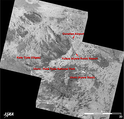 |
Fig. 1 Vicinity of Uluru and Kata Tjuta
Uluru and Kata Tjuta (kmz,1.04MB,Low Resolution) is seen from Google Earth. |
Figure 1 depicts the vicinity of Uluru (Ayers Rock) and Kata Tjuta (The Olgas) rock formations as observed by the Panchromatic Remote-sensing Instrument for Stereo Mapping (PRISM) on board the Advanced Land Observing Satellite (ALOS) "Daichi" in August and September 2006. The Pitjantjajara and Yankunytjatjara aboriginal people (locally known as Anangu) word Uluru means "The Great Rock" and Kata Tjuta means "Many Heads." These sites are sacred to the indigenous people as spiritual places. There are many Pitjantjatjara Dreamtime legends (myths of creation) associated with this place. Ayers Rock was named for the Premier of South Australia, Sir Henry Ayers at the time of its discovery in 1873, but from the 1980s, the aboriginal Uluru and Kata Tjuta are used as the official names.
The bright place on the right-hand side of Fig. 1 is Uluru, one of the world's largest monoliths, 350m high and 10km in circumference. The bright place on the left-hand side of Fig. 1 is Kata Tjuta, which is about 30km from Uluru. These oddly shaped rock formations are a remarkable group of 36 domes. The tallest of the group, Mount Olga, stands 546m in height. They are not familiar in Japan but their size and tremendous impact have a different taste from Uluru.
Accommodations for tourists visiting Uluru and Kata Tjuta are only available at Yurara (Ayers Rock) Resort on the north of the Uluru-Kata Tjuta National Park. The nearest city is Alice Springs, 450km away, and it takes 40 minutes by reciprocating aircraft or 5 hours by bus to reach there. The Connellan Airport is visible to the north of Yurara (Ayers Rock) Resort.
 |
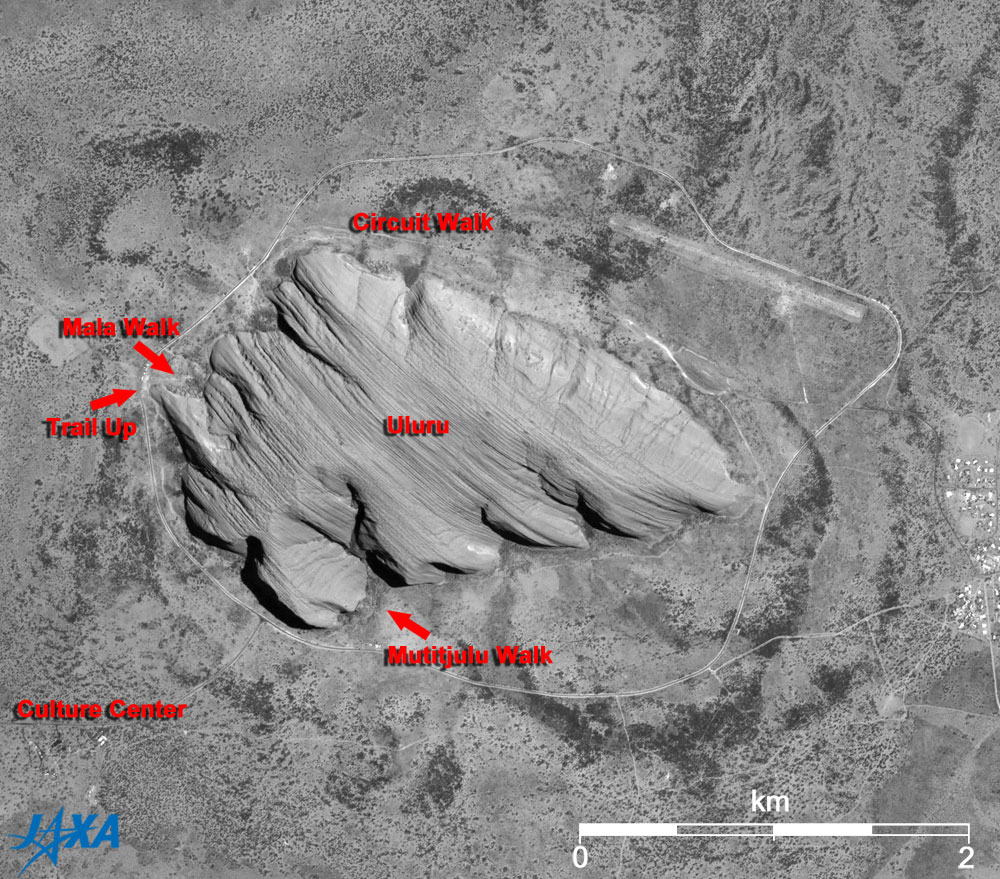
| Fig. 2 Close-up of Uluru |
As Fig. 2 clearly demonstrates, Uluru is a huge isolated rock in a desert. From the ground, however, it seems to be a round table from ground view, with complicated geological layers that run aslant from the upper left to the lower right.
The thick line around Uluru is a circuit road, and the thin line is a sidewalk for sightseeing. The 9.4km-long "Circuit Walk" will take you on a 4-hour tour to visit aboriginal art on rock surfaces and the sacred rocks that they worship. Aboriginal rock art can also be seen in "Mala Walk" and "Mutitjulu Walk," a 1-hour partial tour.
There is one trail up to Uluru, but the guide books request that visitors not climb the rock because of its great spiritual significance to the aboriginal people.
In a Japanese novel, Kyoichi Katayama's youth love story "Cry for Love in the Center of the World, (English title; Socrates in Love)," one of characters was charmed by the aborigine's view of the world, and yearned after the sacred ground of Uluru. A Japanese movie and TV drama based on this novel were shot in Australia.
According to the Uluru-Kata Tjuta National Park home page, Uluru rock is composed of arkose, a course-grained sandstone rich in the mineral feldspar, and Kata Tjuta rocks are conglomerate - gravel consisting of pebbles, cobbles and boulders cemented by sand and mud. This region was once a shallow sea in a basin. A depression in the Earth's crust formed about 900 million years ago, and received layer upon layer of sediment over several hundred million years. Uplifts of mountain ranges took place twice and the shallow sea again collected sediment after that. Mountains were eroded, and huge amounts of sediment were weathered. The rocks of Uluru and Kata Tjuta seen today emerged about 65 million years ago. The layers harder than the surrounding earth and sand suffered less erosion and remained intact.
 |
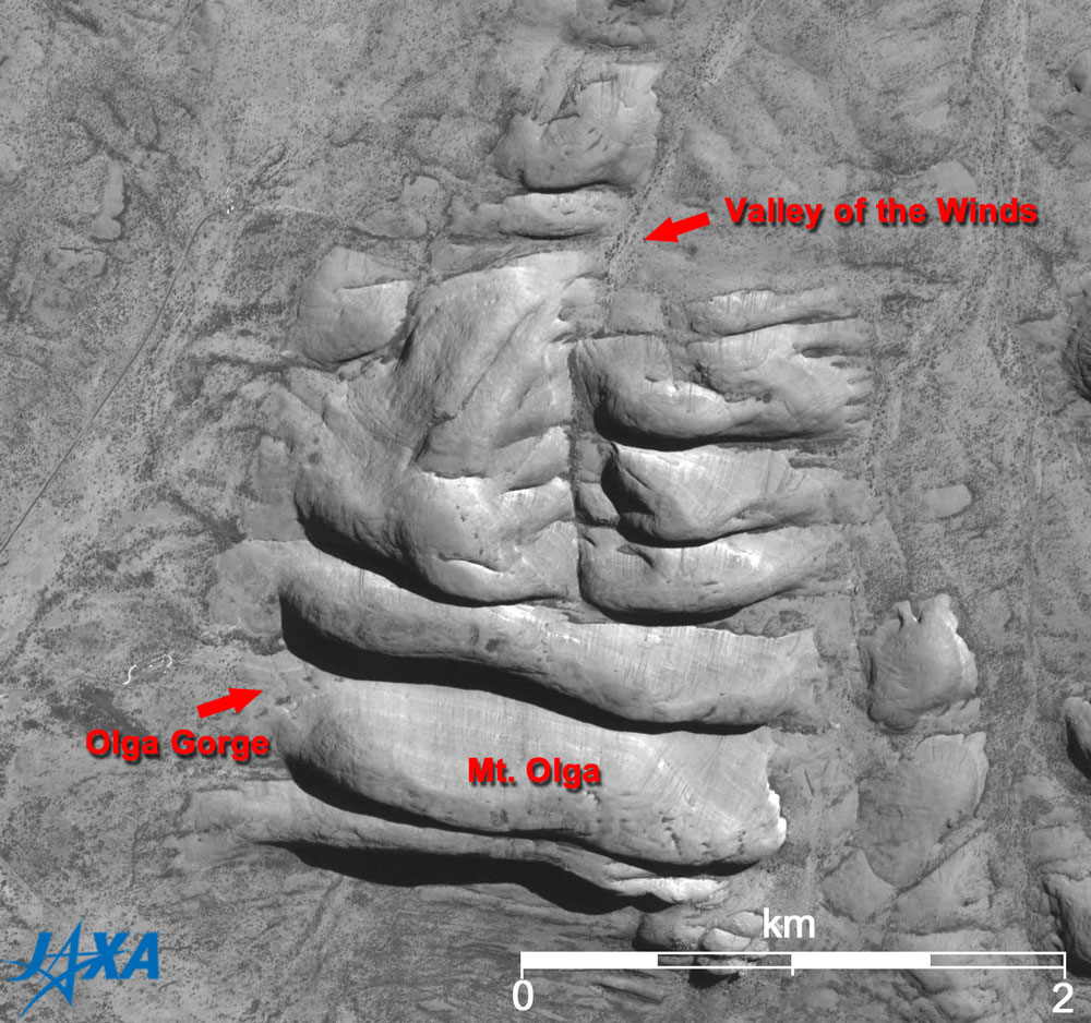
| Fig. 3 Close-up of Kata Tjuta |
There was more erosion at Kata Tjuta than at Uluru, resulting in 36 rock formations of various sizes. There are trails (footpaths maintained so that visitors can experience nature) at "The Olga Gorge" and "Valley of the Winds" in Kata Tjuta. The Olga Gorge is a 2.6km round trip trail, and 546m-high Olga can be seen from the innermost point in the valley. The Valley of the Wind is a 4.2km round trip trail (up to the first observation point), and the 7.4km circuit trip around the domes takes 3 to 4 hours.
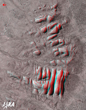 |
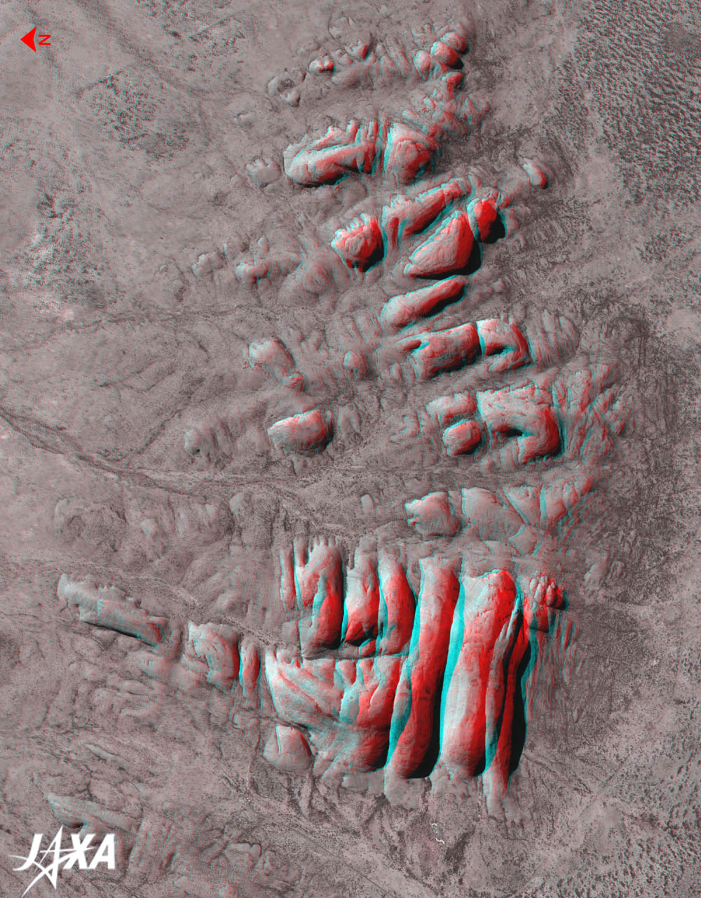
Fig. 4 Three-Dimensional View of the Kata Tjuta (North is to the left.)
(Staring at the image for a long time may cause eye-strain. A color print is available in pdf format. Pdf files for the left and right eyes are also available for stereoscopic viewing.) |
Figure 4 is a 3-D view combining the forward- and nadir-looking images from the three directional images captured by PRISM. The large rock formation in the lower right particularly stands out in this image. The second rock formation from the left is Olga, the highest dome in Kata Tjuta. The Olga Gorge trail is a steep-sided valley between the rock formations at the left (north) of Olga.
Australians have governed this land since the Europeans came, but the Australian government returned ownership of Uluru to the local Pitjantjatjara Aborigines in 1986. Uluru-Kata Tjuta National Park is now jointly managed by the traditional aboriginal owners and Parks Australia, a division of the Australian Government Department of the Environment and Water Resources. The aboriginal people first settled in this area more than 20,000 years ago, and they worshiped this land as a sacred place. Aboriginal people are living on this ground now, and the admission fee to the park supports their life. Uluru - Kata Tjuta National Park was inscribed on the World Heritage List of the United Nations Educational, Scientific and Cultural Organization (UNESCO) for its natural value in 1987 and subsequently listed for its cultural value in 1994. The aboriginal culture was recognized as a form of the traditional belief system of one of the oldest human societies in the world.
Explanation of the Images:
Figs. 1 to 4
| Satellite: |
Advanced Land-Observing Satellite (ALOS) (Daichi) |
| Sensor: |
Panchromatic Remote-sensing Instrument for Stereo Mapping (PRISM) |
| Date: |
0127 (UTC) on September 12, 2006 (right image of Figs. 1 and 2)
0130 (UTC) on August 14, 2006 (left image of Figs.1, 3, and 4)
|
| Ground resolution: |
2.5m (PRISM) |
| Map Projection: |
Universal Transversal Mercator (UTM) |
|
PRISM is an optical sensor for observing ground surfaces with visible and near-infrared signals in the 520 to 770 nanometer (one-billionth of a meter) band. The acquired image is monochrome. PRISM has three independent optical systems (telescopes) to acquire images for nadir, forward, and backward views at the same time. The nadir images were used in Figs. 1 to 3, and the forward image (red) and nadir image (green and blue) were used in Fig. 4. |
|
 |
|