| |
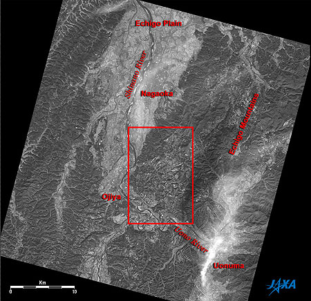 |
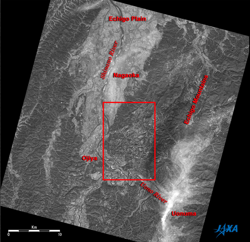
Fig. 1 Damaged area and vicinity two years after the Chuetsu Earthquake
Chuetsu (kmz,1.37MB,Low Resolution) is seen from Google Earth. |
Figure 1 depicts the damaged area two years after the Chuetsu Earthquake, as observed by the Panchromatic Remote-sensing Instrument for Stereo Mapping (PRISM) on board the Advanced Land Observing Satellite (ALOS) "Daichi" in October 2006. The mountainous areas covered with forest look dark, and the plains, including rice paddies and urban areas, look bright. The Echigo Mountains occupy the right half of the figure and extend northeast to southwest. The Shinano River flows from the bottom of the figure to the top, and the Uono River flowing from East to West joins the Shinano River where it meanders. White clouds cover Uonuma in the lower right of the figure. The city areas of Ojiya and Nagaoka along the Shinano River occupy part of the Echigo Plain. The red rectangular frame at the center of the figure includes the main damaged area, the former Yamakoshi Village (presently Nagaoka City), Ojiya City, Nagaoka City and Kawaguchi town, which were struck by the Niigata Chuetsu Earthquake on October 23, 2004. The frame covers the same area as Fig. 1 of "The Visible 'Claw mark' of the Niigata Chuetsu Earthquake as Seen from Space" uploaded on November 24, 2004 ("the image immediately after the earthquake.")
 |
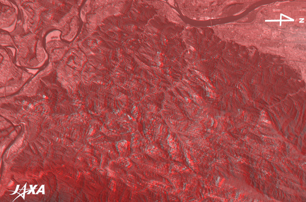
Fig. 2a Three-Dimensional View of the Damaged Area two years after the Chuetsu Earthquake
(Staring at the image for a long time may cause eyestrain. A colored print is available in pdf format. Pdf files for the left and right eyes are also available.) |
Figure 2a was produced by expanding the area for the red rectangular frame of Fig. 1 and then rotating it clockwise by 90° for the three-dimensional view. Therefore, the right is the north, unlike in Fig. 1. If you view this figure with the red and blue glasses, you can see that the plains around the rivers are flat and that the blackish mountainous area has numerous ups and downs overlaid on generally upheaving terrain. The dotted bright areas in the mountainous area indicate newly constructed reservoirs, cultivation ponds for golden carp, and rice terraces (Fig. 5), the slopes with landslide control construction (Figs. 3 and 6), newly constructed roads (Koshi-Mushigame district, Nagaoka City), and landslide-damaged areas that have not yet been restored (Koguriyama district, Ojiya City).
 |
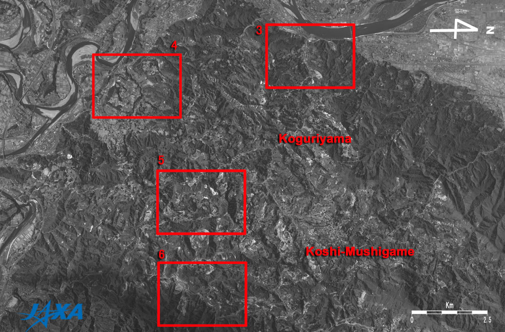
| Fig. 2b Guide Map of the Damaged Area two years after the Chuetsu Earthquake |
This figure covers the same area as Fig. 2a, and the red rectangular frames indicate areas with expanded images in Figs. 3 to 6.
 |
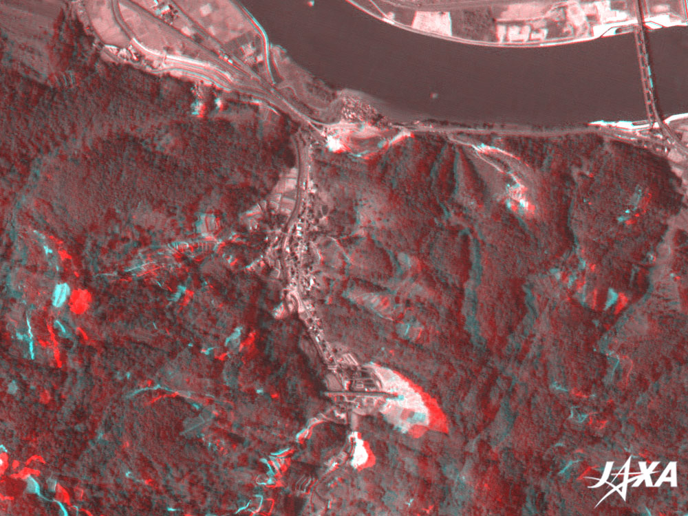
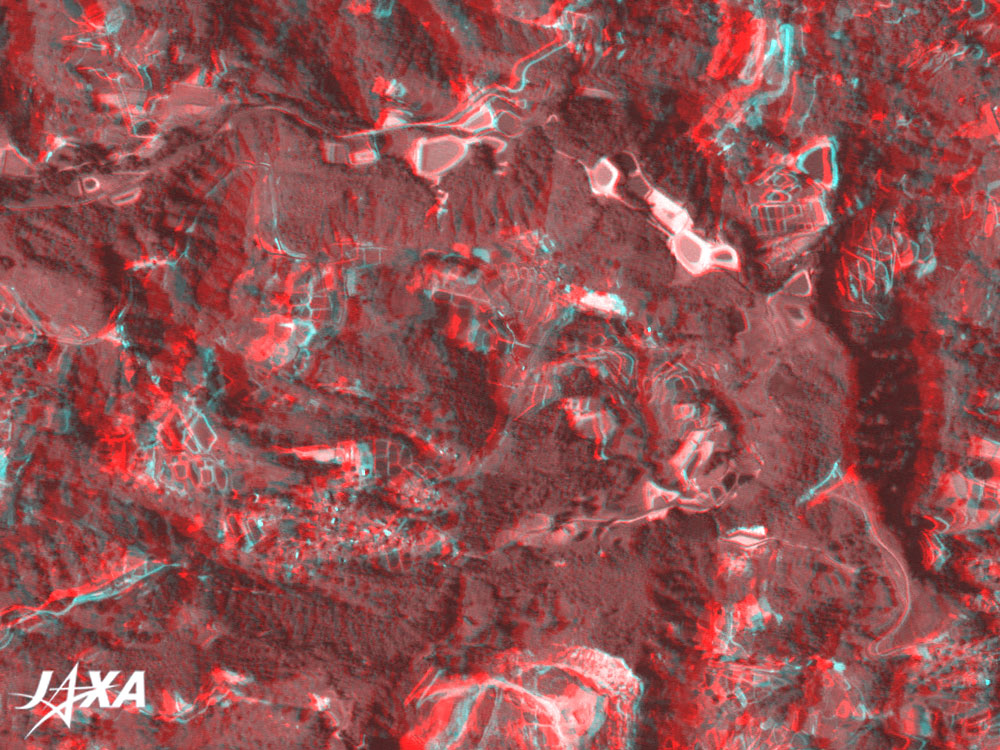
Fig. 3 Myoken-machi, Nagaoka City and Uragara District, Ojiya City
(Staring at the image for a long time may cause eyestrain. A colored print is available in pdf format. Pdf files for the left and right eyes are also available.) |
This figure covers the area of expanded images A to C in the image immediately after the earthquake. You can see a valley in the center of the figure if you view it with red and blue glasses. The area where the prefectural road was cut (at the top of the figure) and the area near the tunnel entrance of Joetsu-shinkansen (super express) at the bottom look bright. This indicates that these areas where landslides occurred during the earthquake have been covered with concrete in order to prevent further landslides.
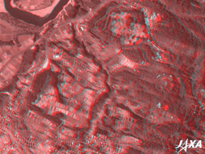 |
Fig. 4 Kawaguchi Town
(Staring at the image for a long time may cause eyestrain. A colored print is available in pdf format. Pdf files for the left and right eyes are also available.) |
The upper left of this figure corresponds to the area of expanded image I in the image immediately after the earthquake. The river terraces with a few steps appear as if you could reach out and touch them if you view the figure with red and blue glasses.
 |
Fig. 5 Koshi-higashi-takezawa District, Nagaoka City (former Higashi-Takezawa District, Yamakoshi Village)
(Staring at the image for a long time may cause eyestrain. A colored print is available in pdf format. Pdf files for the left and right eyes are also available.) |
If you view this figure with red and blue glasses, you can see some brand-new ponds on and around the elliptic ridge.
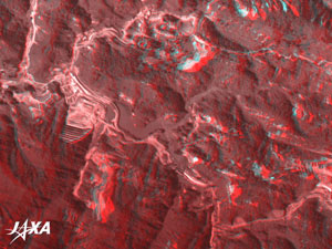 |
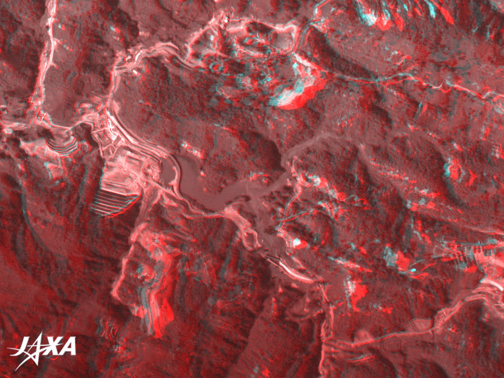
Fig. 6 Koshi-higashi-Takezawa District, Nagaoka City (former Higashi-Takezawa District, Yamakoshi Village)
(Staring at the image for a long time may cause eyestrain. A colored print is available in pdf format. Pdf files for the left and right eyes are also available.) |
This figure covers almost the same area as expanded image G in the image immediately after the earthquake. A gray flat lake can be seen in the center of the figure if you view it with red and blue glasses. This was formed when the flow of the Imo-gawa River was dammed by a landslide during the Chuetsu Earthquake. The areas on the left and the lower left of the figure are landslides areas, but you can find that much earth and sand have been removed and that barriers were constructed to prevent landslides.
Explanation of the Images:
Figs. 1 to 6
PRISM is an optical sensor for observing ground surfaces with visible and near-infrared signals in the 520 to 770 nano-meter (one-billionth of a meter) band. The acquired image is monochrome. PRISM has three independent optical systems (telescopes) to acquire images for nadir, forward, and backward views at the same time. Only the nadir image is used for Figs. 1 and 2b, but a pair of the nadir image (green and blue) and the backward image (red) are used for Figs. 2a, 3, 4, 5 and 6.
|
 |
|