| |
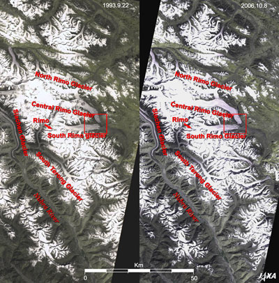 |
Fig. 1 Glaciers in the Eastern Karakoram Range
Karakoram Range (kmz, 1.7MB, Low Resolution) as seen on Google Earth.
|
Figure 1 depicts glaciers in the eastern Karakoram Range. The left image was acquired by the Visible and Near Infrared Radiometer (VNIR) on board the Japanese Earth Resources Satellite-1 (JERS-1) "Fuyo-1" in September 1993; the right image was acquired by the Advanced Visible and Near Infrared Radiometer-2 (AVNIR-2) on board the Advance Land Observing Satellite (ALOS) "Daichi" in October 2006.
The white and purple grey narrow streak in the middle left of each image is the tail end of the 75km long Siachen Glacier, the second greatest glacier in the world's non-polar regions. Beyond the tail is the Nubra River. The Rimo mountain group is visible in the center of the image, and the valleys in the summit areas covered with snow and ice look white. The North Rimo Glacier, the Central Rimo Glacier, the South Rimo Glacier, the South Terong Glacier, and other glaciers covering the valleys also look white. Mt. Rimo (7,386m), the highest peak of the Rimo mountain group, is located near the head of the South Rimo Glacier. Rimo means a striped pattern of glacial moraine in a Turkish dialect.
The Karakoram Range, which lies in parallel on the north side of the Himalayas, extends 500km from west-northwest to east-northeast with a maximum width of 100 km. There are four 8,000m peaks, including K2, the world's second highest peak, and more than eighty 7,000m peaks in this precipitous mountain range. Development of mountain glaciers is remarkable, and many glaciers, such as Baltoro Glacier (62km) and Siachen Glacier, are longer than those in the Himalayas.
Right and left images were acquired in the same season with a 13-year interval. Glacial retreats due to global warming are observed everywhere on the Earth. However, no remarkable change is seen in the mountain top area that looks pure-white in the image, covered with the snow and ice in the Karakoram Range. Neither do any of the many glaciers seem to be reduced in particular, although some difference can be seen at the tail ends of the Central Rimo Glacier and the South Rimo Glacier.
 |
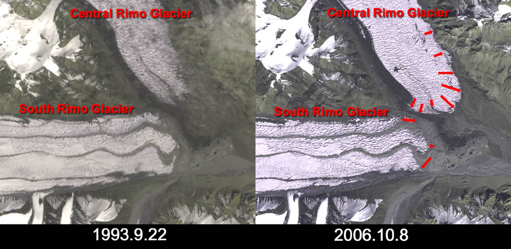
| Fig. 2 Tail Ends of the Central Rimo Glacier and the South Rimo Glacier |
Figure 2 presents the tail ends of the Central Rimo Glacier (upper) and the South Rimo Glacier (lower). The tail end of the South Rimo Glacier retreated slightly, but that of the Central Rimo Glacier extended about 1.3km. If we look closely, we can see that retreating and extending glaciers are mixed in this area, although they are not as remarkable as in this example. The influence of global warming does not seem to be significant here in the eastern Karakoram Range.
Reference:
Himalaya Meihou Jiten (in Japanese), Heibonnsha Ltd., 1996 |
Explanation of the Images:
(Right images of Figs.1 and 2)
AVNIR-2 has four observation bands. The composite images are usually produced by assigning red to Band 3 (610 to 690nm), green to Band 2 (520 to 600nm), and blue to Band 1 (420 to 500nm). The resulting image has natural coloring as if seen by the naked eye. In these images, snow and ice are white or light grey, urban area are light grey, forests are dark green, grasslands are green-yellow, and glacier lakes are light blue. Areas with no data are black.
In the above figures, green is assigned to the sum of 75% of Band 2 and 25% of Band 4, resulting the visibilities of the vegetation are improved.
(Left images of Figs.1 and 2)
The composite images are usually produced by assigning red to the Band 2 (630 to 690 nm), green to the near-infrared Band 3 (760 to 860 nm), and blue to the visible Band 1 (520 to 600 nm). In the above figure, green is assigned to the sum of 75% of Band 2 and 25% of Band 3. The resulting figures have natural coloring as if seen by the naked eye. In these images, snow and ice are white or light purple, urban area is light grey, forests are dark green, and grasslands are green-yellow.
|
 |
|