| |
 |
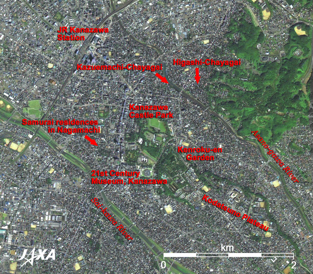
Fig. 1 Central Part of Kanazawa
Kanazawa (kmz, 1.68MB, Low Resolution) as seen on Google Earth.
(Full Image) |
Figure 1 depicts the center of Kanazawa City. The pan-sharpened image was produced from images acquired by the Advanced Visible and Near Infrared Radiometer-2 (AVNIR-2) and the Panchromatic Remote-sensing Instrument for Stereo Mapping (PRISM) on board the Advanced Land Observing Satellite (ALOS) "Daichi" in August and October 2006. The green area in the center of the figure represents the ruins of the castle where the Maeda Family of the Kaga Domain, commonly known as "Kaga's One Million Goku,*1" resided. The 28.5ha Kanazawa Castle Park (six times wider than the Tokyo Dome, Japan's first domed stadium) opened to the public in 1996. The dark green area to the southeast of the park is the Kenroku-en Garden, one of the three renowned gardens in Japan. It was a typical feudal lord garden during the Edo era (1603-1867) and had six distinguished settings known as "Roku-sho." That is how the garden got its name. The Lords' of the Kaga Domains developed this "esplanade around the pond" style of garden for generations over many years.
The Maeda family resided in Kanazawa Castle and developed the castle town for three generations. As the figure shows, the city area spreads out around the Kanazawa Castle. Vestiges of the old castle town period remain, such as the ruins of the samurai residences in Nagamachi, the old streets in Higashi-Chayagai (swank entertainment district) and Kazuemachi-Chayagai.
The Asano-gawa River and Sai-kawa River flow parallel on either side of the Kanazawa Castle Park from southeast to northwest. Between the two rivers is a river terrace. Kanazawa Castle and Kenroku-en Garden were constructed on the tip of Kodatsuno plateau.
South of the castle park is the circular "21st Century Museum of Contemporary Art, Kanazawa" opened in October 2004. It's concept of design is based on that of a public park. Its circular form has no front or back and interrelates to the town. The logo of this museum was adopted from the image of the building seen from the sky. *2
JR (Japan Railways) Kanazawa station is located 1.5km to the west of the castle park. The large roof completed in 2005, under the urban redevelopment project for the area around the station, is visible. It has a curved structure made from an aluminum alloy solid truss and glass. Named the "Hospitality Dome" it is meant to express "the heart of hospitality" and "the heart of kindness" of Kanazawa people, just as one offers his or her umbrella to a person in the rain. This facility made of an aluminum alloy framework, is the largest building in Japan occupying 3,000 m2 area, with a maximum height of 29.5m. There are 3,019 panes of laminated tempered glass weighing 90kg each. Some blue-roofed buildings are visible on the east side of the station, casting their shadows toward the northwest. Tall, blue-roofed buildings are also seen on both sides of the Hyakuman (one million)-goku Avenue running north to south on the west of Kanazawa Castle Park.
During the civil war period, Toshi-ie Maeda established his one million goku Kaga Domain here in Hokuriku (northland). An original culture and various industrial arts were born in Kanazawa, which developed as the castle town of the Kaga Domain, and remain there today. From the satellite imagery, the contrast between the traditional castle town and today's civil engineering and construction can be seen.
Referenced:
*1 Goku is a unit to measure the weight of rice grains. One goku is about 143 kg, which is equivalent to the amount of rice that one man eats per year, and requires a rice field area of 990 m2 to produce. Thus, the number of gokus is also used to express the extent of feudality which produces that amount of rice.
Referenced site:
*2 Museum Logo(The site of the 21st Century Museum of Contemporary Art, Kanazawa)
|
Explanation of the Image:
| Satellite: |
Advanced Land-Observing Satellite (ALOS) (Daichi) |
| Sensor: |
Panchromatic Remote-sensing Instrument for Stereo Mapping (PRISM) and Advanced Visible and Near Infrared Radiometer-2 (AVNIR-2) |
| Date: |
1045 (JST) on September 8, 2006 (PRISM) and 1107 (JST) on October 10, 2006 (AVNIR-2)
|
| Ground resolution |
2.5 m (PRISM) and 10m (AVNIR-2) |
| Map Projection: |
Universal Transversal Mercator (UTM) |
PRISM is an optical sensor for observing ground surfaces with visible and near-infrared signals in the 520 to 770 nano-meter (one-billionth of a meter) band. The acquired image is monochrome. PRISM has three independent optical systems (telescopes) to acquire images for nadir, forward and backward views at the same time. Only the nadir image was used in this article.
AVNIR-2 is equipped with a pointing function by which it can shift its observation area perpendicular to the ALOS's moving direction, and it can observe ground surfaces with four spectral bands.
First, the color image was produced by assigning red to Band 3(610 to 690 nm), green to Band 2 (520 to 600 nm), and blue for Band 1 (420 to 500 nm). Then, the image was transformed into Hue, Saturation and Intensity, and the Intensity was replaced by the PRISM image. The Hue, Saturation and Intensity data were then reversed into a color image. As a result, a virtual 2.5 m ground-resolution color image was obtained. This kind of high-resolution color image, composed by combining the higher resolution monochrome image and the lower resolution color image, is called a pan-sharpened image. The resulting image has natural coloring as if seen by the naked eye. In this image, forests are deep green, grass fields or farms are light green, bare ground is ocher, roads are grey, and roofs are colors as they are.
Due to the AVNIR-2's large pointing angle of 34.30°, the original image used was distorted due to the height of the object from the ground. Pan-sharpening was performed after ortho-projection correction was applied to the original image using the ground elevation data obtained from the PRISM data.
The full image is the original AVNIR-2 scene used for producing pan-sharpened images. The coloring is white for snow, blue for sea, khaki or brown for farms, grey for urban area, and black for areas with no data. |
|
 |
|