| |
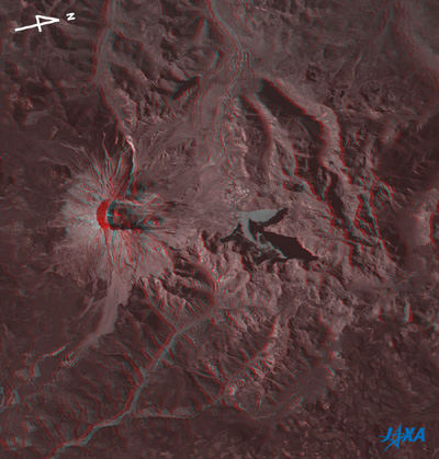 |
Fig. 1. Three-Dimensional View of Mt. St. Helens
(Staring at the image for a long time may cause eyestrain. A colored print is available in pdf format. Pdf files for the left and right eyes are also available.) |
Figure 1 depicts Mt. St. Helens, Washington, U.S.A., as observed by the Panchromatic Remote-sensing Instrument for Stereo Mapping (PRISM) on board the Advanced Land Observing Satellite (ALOS) "Daichi" in October 2006. When viewing Fig. 1 with red and blue glasses,*1 you can see distinctly that the cone-shaped Mt. St. Helens looks steeply peaked, that the wall on the north side of the big crater collapsed, that there is a lava dome in the sunk crater, that the surface of the Spirit Lake is flat, that there are branched deep valleys on the northeastern side of the mountain, and that there are steep ridges on the northwestern side of the mountain.
Mt. St. Helens, 2,550m above sea level, is located 80km southwest of Mt. Rainier, the highest peak in the Cascade Range (4,392m above sea level); 160km south of Seattle; and 60km northeast of Portland, the state capital of Oregon. It formerly had a beautiful likeness of Mt. Fuji in Japan. However, it had a major eruption in May 1980 that blew away its crest. The summit fell as much as 500m, and the 2km-by-3km horseshoe-shaped crater openning on the north side emerged. Since then, the lava dome has been growing in the crater bottom and the volcanism has continued with eruptions in October 2004 and in March 2005*2.
Mt. St. Helens and its vicinity were designated as Mount St. Helens National Volcanic Monument in 1982 after the large-scale eruption and are now managed by the U. S. Department of Agriculture (USDA) Forestry Service.
 |
| Fig. 2 Changes around Mt. St. Helens |
The upper image of Fig. 2 depicts the vicinity of Mt. St. Helens as observed by the Advanced Visible and Near Infrared Radiometer-2 (AVNIR-2) on board the Advanced Land Observing Satellite (ALOS) "Daichi" acquired at the same time as Fig. 1. Surrounded by the green forests and grassland, Mt. St. Helens looks ashy purple, indicating that the lava and volcanic ash are exposed, not covered with vegetation. You can also find that the volcanic ash pours into North Fork Toutle River in the northwest and the Muddy River in the east, and that the deposit of the volcanic ash remains faintly visible around Spirit Lake and Coldwater Lake.
The lower image of Fig. 2 was acquired by the Visible and Near Infrared Radiometer (VNIR) on board the Japanese Earth Resources Satellite-1 (JERS-1) "Fuyo-1" in August 1995. You can see the ground surface features well except for some clouds covering the mountaintops.
The upper and the lower images differ in brightness, the way the ground surface unevenness appears, and the degrees to which plants are flourishing, depending on the difference in the observed season. However, comparing these images reveals that the volcanic ash on the North Fork Toutle River was swept away to the lower reaches and that the vegetation is recovering in areas formerly covered with volcanic ash southeast of Spirit Lake.
Spirit Lake appears to have changed shape because the volcanic ash floating on the surface of the lake is blown about by the wind. This is supported by the fact that the gray areas of volcanic ash on the surface of the lake look flat when Fig. 1 is viewed in three dimensions.
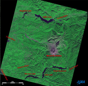 |
Fig. 3. Wide-angle picture around Mt. St. Helens
Mt. St. Helens (kmz, 1.39MB, Low Resolution) as seen on Google Earth. |
North and south of Mt. St. Helens there are artificial lakes made by damming the rivers. The Columbia River is visible in the bottom left corner of the figure. It originates in the Canadian Rockies and has the big flow following that of the Mississippi in North America.
The Riffle Lake and the Mayfield Lake at the top of the figure are dammed lakes made on the Cowlitz River that originates in Mt. Rainier. The river is joined by the Toutle River that originates in Mt. St. Helens, then joins the Columbia River and pours into the Pacific Ocean. Kalama River, which originates in the southwest foot of Mt. St. Helens, also joins the Columbia River. The Lewis River flows south of Mt. St. Helens and flows to the west via the Swift Reservoir, Yale Lake, and Merwin Lake, which were created by the dams, and joins the Columbia River.
Explanation of the Images:
(Fig. 1)
| Satellite: |
Advanced Land-Observing Satellite (ALOS) (Daichi) |
| Sensor: |
Panchromatic Remote-sensing Instrument for Stereo Mapping (PRISM) |
| Date: |
1912-1913 (UTC) on October 11, 2006 |
| Ground resolution |
2.5 m |
| Map Projection: |
Universal Transversal Mercator (UTM) |
|
Fig. 1 was composed of nadir (red) and forward-looking (green and blue) images. Therefore the three-dimensional view looks natural when viewed from just the right side. The left side is the satellite flight direction because the nadir image of the satellite is seen with the left eye and the forward-looking image with the right eye. The left side nearly corresponds to south. Note that the right side is north in Fig. 1 even though the top is north in Figs. 2 and 3. |
(Figs. 2 upper and 3)
| Satellite: |
Advanced Land-Observing Satellite (ALOS) (Daichi) |
| Sensor: |
Advanced Visible Near-Infrared Radiometer type-2 (AVNIR-2) |
| Date: |
1913 (UTC) on October 11, 2006 |
| Ground resolution |
10 m |
| Map Projection: |
Universal Transversal Mercator (UTM) |
|
AVNIR-2 has four observation bands. Figs. 2 upper and 3 were composed by assigning red to visible Band 3 (610 to 690nm), green to near-infrared Band 4 (760 to 890nm), and blue to visible Band 2 (520 to 600nm). As a result, the figures have a nearly natural coloring, with vegetation slightly emphasized. In these images, clouds are white, exposed rocks and volcanic ash are grey purple, farmland and grassland are light green, and forests are dark green. Areas with no data are black. North side slopes look blackish. |
(Fig. 2 lower)
| Satellite: |
Japanese Earth Resources Satellite -1 (JERS-1) (Fuyo-1) |
| Sensor: |
Visible and Near Infrared Radiometer (VNIR) |
| Date: |
1923 (UTC) on August 3, 1995 |
| Ground resolution |
18.3m x 24.2m |
| Map Projection: |
Universal Transversal Mercator (UTM) |
| These images were produced by assigning red to the visible channel (630 to 690 nm), green to the near-infrared channel (760 to 860 nm), and blue to the visible channel (520 to 600 nm). You can interpret the resulting images in the almost same way as the above AVNIR-2 images. |
|
 |
|


