| |
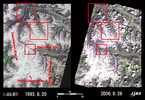 |
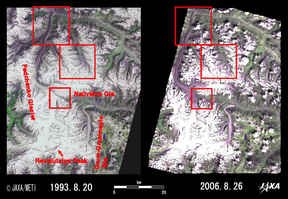
| Fig. 1 Vicinity of Fedchenko Glacier |
Figure 1 depicts Fedchenko Glacier and its vicinity in Pamir. The left image was observed by the Visible and Near Infrared Radiometer (VNIR) on board the Japanese Earth Resources Satellite-1 (JERS-1) "Fuyo-1" in August 1993; the right image was observed by the Advanced Visible and Near Infrared Radiometer-2 (AVNIR-2) on board the Advanced Land Observing Satellite (ALOS) "Daichi" in August 2006. Changes during 13 years between the two images are apparent in spite of some dotted clouds in the right image.
Fedchenko Glacier originates from the northwestern slope of the Revolutsiya Peak (Revolution Peak, 6,974m above sea level) at the bottom of the image and flows north. Since the southern (upstream) glacier in a high-altitude valley covered with snow and ice reflects sunlight strongly, it appears pure white. With the glacier flow to north (downstream), the surface ice and snow starts melting and becomes studded with rock debris, so it looks purple as it reflects sunlight rather weakly.
You can see that the glacial snow and ice area (pure white in the images) contracted and retreated, although the two images were observed in the same season. You can also note that the light green area covered with vegetation grows during these 13 years.
 |
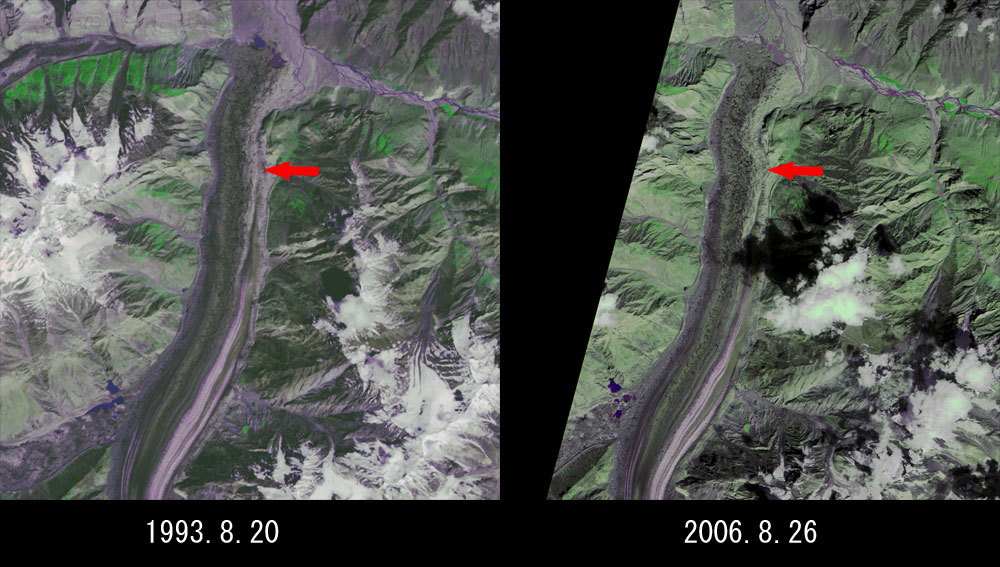
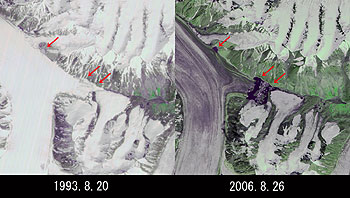
Fig. 2 Close-up Image of Downstream Fedchenko Glacier
Fedchenlco Glacier(kmz, 1.06MB, Low Resolution) as seen on Google Earth. |
The tail end of the Fedchenko Glacier and a glacial lake are visible in the top of Fig. 2. These positions have not changed much in 13 years. However, streaks on the glacier indicated by the arrow were straight in 1993, but are wound in 2006. Fedchenko Glacier flows 67cm per day, which becomes a 3 km drift in 13 years. The change is the result of this movement. The light green area covered with vegetation also grew.
 |
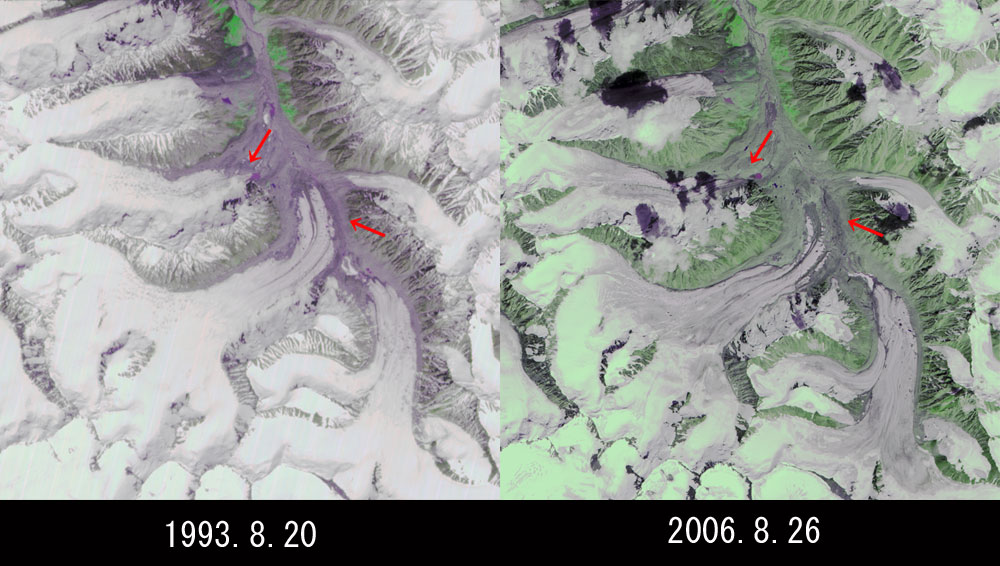
| Fig. 3 Close-up Image to the north of Nalivkina Glacier |
Comparison of the two images reveals that the glaciers in 1993 (indicated by arrows) disappeared, that the pure white snow and ice area decreased while the light purple area produced by melting of the glacier surface increased, and that the light green area covered with vegetation increased.
 |
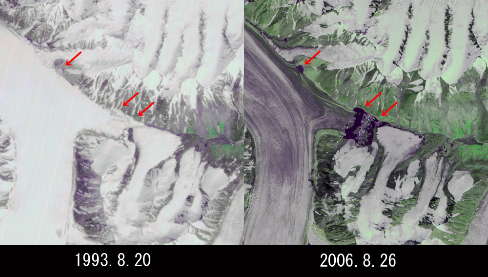
| Fig. 4 Close-up Image of Midstream of Fedchenko Glacier |
Comparing the two images, you can find that the glaciers indicated by arrows in 1993 melted and dark-purple glacial lakes appeared in 2006. The island between the two glacial lakes in the middle of the right image is considered to be created by moraine (sediments of sands and rocks carried by glaciers).
Pure white surfaces of Fedchenko and other glaciers start melting, turn purple, and contract.
The grey or light purple area with exposed bare rocks and moraines in the left image became light green in the right image, indicating vegetation.
 |
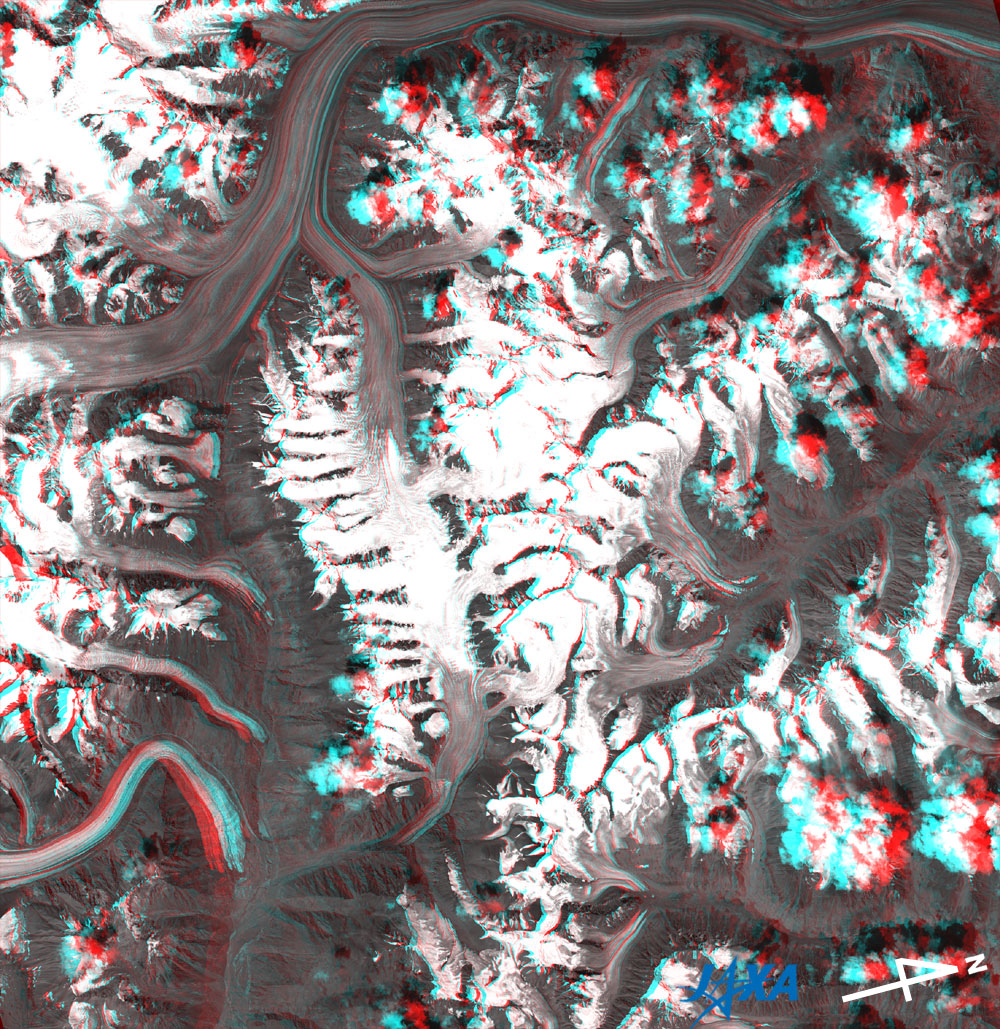
Fig. 5 Three-dimensional View of Fedchenko Glacier
(Staring at the image for a long time may cause eye strain. A colored print is available in pdf format. Pdf files for left and right eyes are also available.)
|
Figure 5 was acquired by the Panchromatic Remote-sensing Instrument for Stereo Mapping (PRISM) on board the Advanced Land Observing Satellite (ALOS) "Daichi" in August 2006 at the same time as AVNIR-2. Rugged peaks, deep valleys, and glaciers in the valley can be enjoyed in stereoscopic view by looking through red and blue glasses. Note that the glacial area that started to melt (the area changing from white to purple in Figs. 1 to 4) is located at lower altitude, but the area of higher altitude remains white.
Explanation of the Images:
(Left images of Figs.1 to 4)
| Satellite: |
Japanese Earth Resources Satellite-1 (JERS-1)(Fuyo-1) |
| Sensor: |
Visible and Near Infrared Radiometer (VNIR) |
| Date: |
0611(UTC) on August 20, 1993 |
| Ground resolution |
18.3 mx24.2 m |
| Map Projection: |
Universal Transversal Mercator (UTM) |
| The composite figures were produced by assigning red to the visible channel (630 to 690 nm), green to the near-infrared channel (760 to 860 nm), and blue to the visible channel (520 to 600 nm). The resulting figures have natural coloring with a slightly emphasized green for vegetation and light purple for snow and ice appearing as if seen by the naked eye. In these images, snow and ice are white or light purple, forests are dark green, and grasslands are green-yellow. Areas with no data are black. |
(Right images of Figs. 1 to 4)
| Satellite: |
Advanced Land-Observing Satellite (ALOS) (Daichi) |
| Sensor: |
Advanced Visible Near-Infrared Radiometer type-2 (AVNIR-2) |
| Date: |
0604(UTC) on August 26, 2006 |
| Ground resolution |
10 m |
| Map Projection: |
Universal Transversal Mercator (UTM) |
|
AVNIR-2 has four observation bands. The composite images are usually produced by assigning red to Band 3 (610 to 690nm), green to Band 4 (760 to 890nm), and blue to Band 2 (520 to 600nm). The resulting images have natural coloring with a slightly emphasized green for vegetation and light purple for snow and ice appearing as if seen by the naked eye. In these images, snow and ice are white or light purple, forests are dark green, grasslands are green-yellow, and glacier lakes are dark purple. Areas with no data are black. |
(Fig.5)
|
 |
|