ページの先頭です。
本文へジャンプする。
【Important Notices】This page is an archive page of information published in the past. Since the update has been completed, it may contain broken links or outdated information. For the latest information, please use the new site Earth-graphy (earth.jaxa.jp).
ここからサイト内共通メニューです。
サイト内共通メニューを読み飛ばす。
サイト内共通メニューここまで。
ここから本文です。

Seen from Space 2006

Munich: The capital of the German Federal State of Bavaria

  In this issue, we introduce Munich, where the opening game of the World Cup football was played.
Fig. 1. Munich and Vicinity
Figure 1 depicts the vicinity of Munich as observed in May 1993 by the optical sensor aboard the Japanese Earth Resources Satellite-1 (Fuyo-1). Munich is the third largest city in Germany with a population of 1.3 million following Berlin (3.4 million) and Hamburg (1.7 million). Lake Ammer and Lake Starnberg are in the lower left, Lake Speich in the upper right, and the Isar River flowing from the bottom to upper right. The Isar River originates in the Tirol Mountains in Switzerland and flows to the east through the city area in Munich and finally joins the Danube River. The city area of Munich appears ashy purple in the center, and the Munich Airport (the Franz Josef Strauss Airport), which was opened in May 1992, can be seen in the northeastern part of the city.

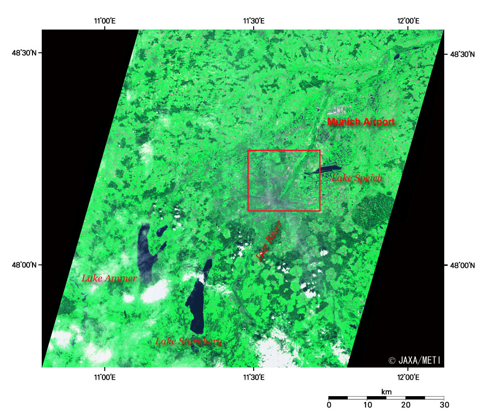
Munich is located in Southern Bavaria 50 km from the northern end of the Alps, on a plain 500 m above sea level. The warm wind blowing beyond the Alps is called a föhn (foehn) in German and sometimes brings a rapid rise in air temperaure. The "föhn" of the föhn Phenomenon is derived from this wind.

Fig. 2. Expanded Image of Munich
Figure 2 is the expanded image of Munich. Most areas of the figure are farmland or grassland depicted in light green or light brown. The city area is at the bottom center. You can see the Olympic Stadium, which was the main venue of the Munich Olympics in the summer of 1972 and the World Cup football in 1974, at the center of the figure. However, the venue of the World Cup football for this year is the football-specific Allianz Arena, which was constructed just near the interchange of the expressways (autobahn) 8 km northeast of the Olympic Stadium.
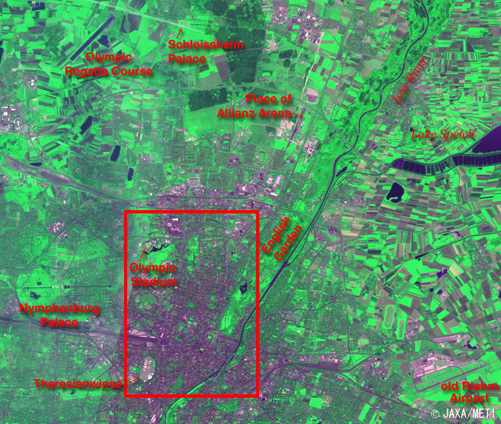
It is called "WM Stadion Munich" during the World Cup. Lake Speich is on the right, and the Isar River flows from the bottom to the upper right.

The old Riehm Airport can be seen in the lower right area of the image, but it was closed after the opening of the Franz Josef Strauss Airport. The New Munich Trade Fair Center was constructed on the vacant lot and opened in February 1998.

You can see the Schleißheim (Schleissheim) Palace and Olympic Regatta Course at the top. The palace was built during the 18th century as the summer palace for the Wittelsbach family, who governed the Dukedom of Bavaria (the Kingdom of Bavaria since 1806) from 1180 to 1918. The Nymphenburg Palace on the lower left is also a summer palace built in the 17th to 19th century also for Wittelsbach family.

Fig. 3. Munich City Area
Munich (kmz, 258 KB, Low Resolution) as seen on Google Earth.
Figure 3 is an expanded image of the city area of Munich. You can see the Olympic Park containing the Olympic Stadium on the upper left. The English Garden on the upper right. The English Garden has been in existence since 1789 and is one of the world's largest urban public parks with an area of 3.7 square km. It is wider than Central Park in New York.

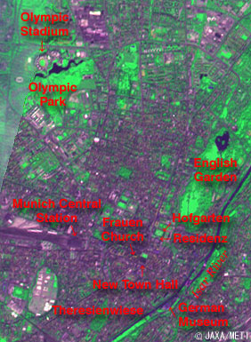
The world's largest beer festival, known as "Oktoberfest," is held every year from mid-September to the beginning of October (September 16 to October 3 in 2006) at Theresienwiese, which can be seen in the lower left area of the image. The festival originated with the promenade race held commemorating the marriage of Crown Prince Ludwig in the Kingdom of Bavaria on October 12, 1810. The venue is called Theresienwiese (Therese's lawn) for Crown Princess Therese.

The Munich Central Station can be seen in black on the northeastern side of Theresienwiese. The New Town Hall, which was built between the second half of the 19th century to the beginning of the 20th century, is on the east side of Munich Central Station. The Frauen Church, with its onion-domed twin towers, is just above and to the left of the New Town Hall and is the symbol of Munich. The Residenz just to the upper right of the New Town Hall was the residence castle built for Wittelsbach family during the 14th to 18th century. At present, it is used as the museum and the treasury. The Bavarian State Opera is also accommodated there. Hofgarten (the royal garden) can be seen on the northern side of the Residenz.

The German Museum, which is on a sandbank (in the lower right) in the Isar River, is one of the biggest and the oldest science museums in the world.

Munich and Sapporo, Japan, are twin cities based on the relationship that the1972 Winter Olympics was hosted in Sapporo and the 1972 Summer Olympics hosted in Munich.


Reference Sites:
Sightseeing in Munich
Official site of Oktoberfest

Explanation of the images:
Figs. 1 to 3
Satellite: Japanese Earth Resources Satellite-1 (JERS-1) (Fuyo-1)
Sensor: Visible and Near Infrared Radiometer (VNIR)
Date: May 9, 1993 (Fig. 1),May 9, 1993 (left side) and August 4, 1993 (right side) (Figs. 2 and 3)
Ground resolution: 18.3 m x 24.2 m
Map Projection: Universal Transversal Mercator (UTM)
The figures were produced by assigning red to visible Band 2 (630 to 690 nm), green to near-infrared Band 3 (760 to 860 nm), and blue to visible Band 1 (520 to 600 nm). The resulting figures have a natural coloring with slightly emphasized vegetation.
In these images, the clouds are white, the urban area is purple-gray, the forests are dark green, the grasslands and farmlands are light green or light brown, and water surfaces (lakes, ponds, rivers, etc.) are black. Areas with no data are also black.

Related Sites:
Venues of Football World Cup Seen from Space
Hamburg and the Kiel Canal connecting the North Sea and the Baltic Sea
Berlin: The city divided by a wall (Part2)
Berlin: The city divided by a wall (Part1)
Land, Seen from Space

本文ここまで。
image:Satellite Navigator
image:Satellite Applications and Operations Center(SAOC)
Earth Data Collection by JAXA Satellites
image:ページTOP