| |
 |
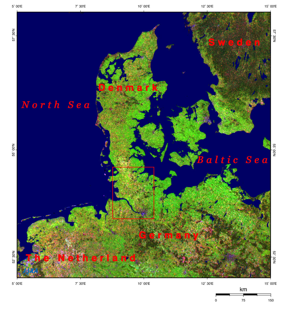
| Fig. 1. Vicinity of Northern Germany and Denmark |
Figure 1 depicts the vicinity of Northern Germany and Denmark as observed by the Advanced Earth Observing Satellite-II (Midori-II). The Kiel Canal is located at the root of the Jutland Peninsula near the border between Germany and Denmark. It is formally called the North Sea-Baltic Sea Canal (Nord-Ostsee Kanal) and is ranked among the world's three major canals with the Suez and Panama Canals. This waterway is 98 km long and 102m wide with an 11m water-depth and has international importance. The Treaty of Versailles granted right-of-way to merchant vessels of all nations in 1919, and many such vessels traverse the canal every day. Although there is little difference in the sea surface levels of the North Sea and the Baltic Sea, there are locks at either end of the canal to compensate for the tidal effect.
 |
| Fig. 2. Kiel Canal connecting the North Sea and the Baltic Sea |
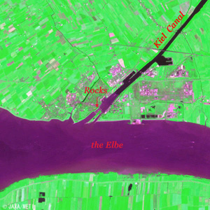
Figure 2 shows the Kiel Canal as observed by the optical sensor aboard the Japanese Earth Resources Satellite-1 (Fuyo-1). The black narrow streak is the Kiel Canal connecting Kiel Bay in the Baltic Sea (upper right black area) and the Elbe flowing into the North Sea (lower left black area). The purple-red area at the easternmost end of the canal is Kiel, the capital city of the Schleswig Holstein State (the Holstein variety of dairy cow originates from here). The lower right purple-red area is Hamburg, the second largest city in Germany, after Berlin.
Before construction of the canal, commerce between the North Sea and the Baltic Sea was conducted around the Jutland Peninsula in Denmark through the course passing through the 20 km wide Øresund Strait just in front of Copenhagen. The offing of the Jutland Peninsula often runs high, and Denmark had imposed a high passenger tax at the narrow Øresund Strait. For this reason, the Hanseatic League cities, such as Hamburg and Lubeck, connected the two seas by constructing the small Eider Canal. Completed in 1784, it ran from Kiel to the Eider River, extending the Eider River. This canal was beneficial to agriculture as well as commerce, because its water was used for surrounding irrigation and it raised the agricultural production of this district.
However, the Eider Canal was only 29m wide and 3m deep, and vessel passages were very restricted. Construction of the new Kiel Canal was started in 1887. It extended the old canal from Kiel to Rendsburg and opened a new route to Brunsbuttel on the Elbe to the south instead of the Eider River. The canal was completed eight years later in 1895.
 |
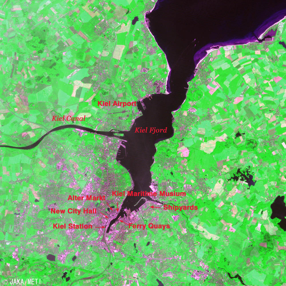
| Fig. 3. Vicinity of Kiel |
Figure 3 is an expanded image of the vicinity of Kiel. The Kiel Fjord connecting with the Baltic Sea is approximately 17 km deep. You can see Kiel airport and the mouth of the Kiel Canal in the middle of the west coast of the fjord. The purple-red area at the deepest part of the fjord is the city area of Kiel. The German naval base has been located there since 1865, and the local shipbuilding industry has prospered as a result. The other areas appear mostly green, indicating the presence of farmland and pastures.
The railroad station is located on the west coast at the head of Kiel Fjord, and the New City Hall is situated to the north. The old city area, which escaped air raids during World War II, is located on the north side, and the "Alter Markt" (old market) and St. Nicolai Church are at the center. There are the quays where regularly scheduled ferries serving between Kiel and cities on the Baltic Sea depart and arrive on the east coast of Kiel Fjord. The large shipyards are visible to the north.
"Kiel Week," the world's largest sailing regatta, is an annual festival held off the Kiel coast in the week in late June that includes the longest day in the year. It originated with the 1882 regatta, and now 2,000-sailboats and 5,000 sailors participate. The Schleswig Holstein Music Festival is held at the same time, and it has become the greatest summer festival in Northern Europe. When the Olympic Games were held in Berlin in 1936 and Munich in 1972, the Olympic sailing competitions were held off Kiel.
 |
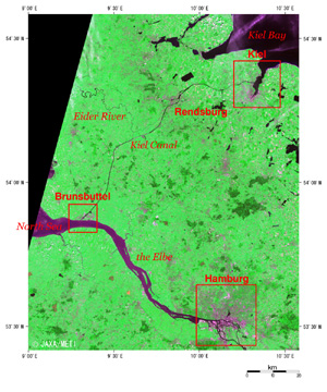
| Fig. 4. Vicinity of Brunsbuttel |
Figure 4 is an expanded image of the vicinity of Brunsbuttel. The locks can faintly be seen near the entrance in Kiel Canal. The water of the canal is black, and the water of the Elbe is purple-red. You can see that the water of the Elbe enters into the canal across the locks.
 |
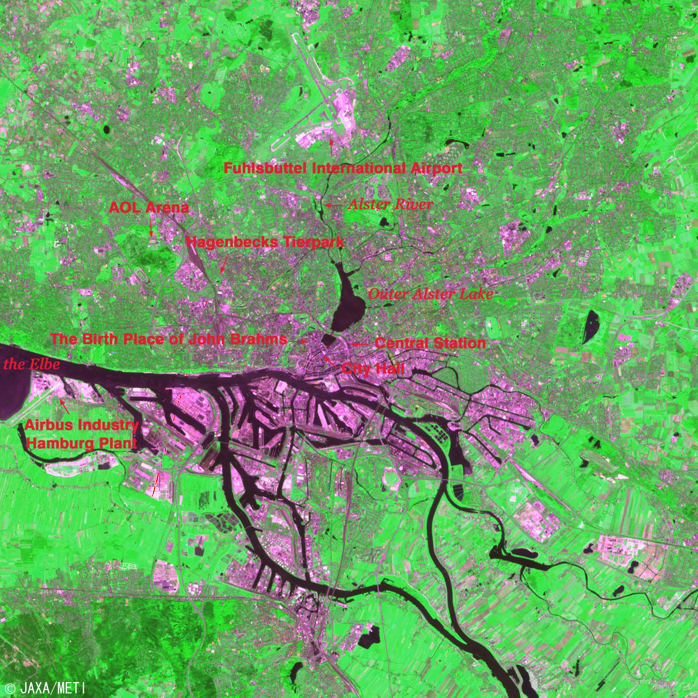
Fig. 5. Hamburg
Hamburg (kmz, 4.28 MB, Low Resolution) as seen on Google Earth. |
Figure 5 is an expanded image of Hamburg. The city area and harbor facilities are purple-red; the black area is the water surface. The Elbe divides into the North Elbe and the South Elbe at the upstream on the lower right, joins again, and flows to the left. From the top, the Alster River flows down to the artificial Outer Alster Lake and Inner Alster Lake near the city area and joins to the North Elbe. Fuhlsbuttel International Airport with its two runways can be seen in the upper section. The famous Hagenbecks Tierpark "no fence" zoo and the AOL Arena football stadium are seen to the southwest. This stadium is the home field of Hamburg SV, which belongs to the top German professional football league "Bundes League." This team is the veteran team that has never been relegated to the minor league since the German Bundes League was founded in 1919. Naohiro Takahara is on the team now. Five games of the German World Cup will be held at this stadium from June to July 2006.
On the south coast of the Elbe in the lower left of the image is the Hamburg plant of Airbus Industry and its associated runway. Among the many Airbus plants in Europe, final assembly is performed only in Hamburg and at Toulouse in France. The Hamburg plant is responsible for fuselage assembly and final assembly of the world's largest passenger aircraft the A380, which completed its virgin flight in April 2005.
Hamburg is the second largest city in Germany with a population of about 1.7 million, and it is the center of the economy of northern Germany. There are many scientific research institutes, including the University of Hamburg. It is the birthplace of Johannes Brahms (1833-1897) and Felix Mendelssohn (1809-1847), and home of the North German Radio Symphony Orchestra. Hamburg is the harbor city at the mouth of the Elbe. It prospered during its membership in the "Hanseatic League," and is now designated a city-state and one of the 16 independent states that constitute the Federal Republic of Germany.
Explanation of the images:
Fig. 1
| Satellite: |
Advanced Earth Observing Satellite - II (ADEOS-II) (Midori-II) |
| Sensor: |
Global Imager (GLI) |
| Date: |
May 25, 2003 - June 9, 2003 (16 days) |
| Ground resolution: |
1 km |
| Map projection: |
Mercator |
|
It is difficult to obtain a single cloud-free, clear image of this area, so this cloud-free special color composite was produced by assigning red to mid-infrared channel 28 (1,640 nm), green to near-infrared channel 19 (865 nm), and blue to visible channel 13 (678 nm) based on the above-mentioned 16 day data. This image can be interpreted as follows.
|
| Light green-Dark green: |
vegetation |
| Pink-Thin red: |
open ground, soil |
| Purple: |
urban area |
| Dark blue (it has smeared away): |
water surface |
Figs. 2 to 4
| Satellite: |
Japanese Earth Resources Satellite-1 (JERS-1) |
| Sensor: |
Visible and Near Infrared Radiometer (VNIR) |
| Date: |
June 29 and 30, 1993 |
| Ground resolution: |
18.3 m x 24.2 m |
| Map projection: |
Universal Transversal Mercator (UTM) |
|
The figures were produced by assigning red to the visible channel (630 to 690nm), green to the near-infrared channel (760 to 860nm), and blue to the visible channel (520 to 600nm). The resulting figures have natural coloring with slightly emphasized vegetation, appearing as if seen by the naked eye. In these images, snow and ice are white or pale purple, city areas are ash purple, forests are dark green, grasslands and farmlands are olive green, and water surfaces and areas with no data are black.
|
|
 |
Related Sites:
 The Panama Canal: A shortcut for ships crossing the isthmus The Panama Canal: A shortcut for ships crossing the isthmus
The Suez Canal: A shortcut for ships through the desert
Berlin: The city divided by a wall (part 2)
Berlin: The city divided by a wall (part 1)
Land, Seen from Space
Appendix:
Shortcut Effect, Traffic and Restrictions of Kiel Canal:
The nautical route between Helsinki, Finland and Dover in the U.K. via the Øresund Strait covers 1,223 nautical miles (nm), while the distance via the Kiel Canal is 1,045 nm, saving 178 nm. There are 778 nm between Kiel and Dover via the Øresund Strait, but only 410 nm via the Kiel Canal, a saving of 368 nm.
The number of vessels passing through Kiel Canal has gradually increased in recent years, and about 42,000 ships and 125 million gross tons were recorded in 2004. According to the 2003 statistics, 45.7 million tons of cargo were carried from the Baltic Sea to the North Sea via the Kiel Canal, while, conversely, 26.5 million tons were carried from the North Sea to the Baltic Sea. There was much more cargo carried from the Baltic Sea side to the North Sea side. The cargo structure is as follows: general cargo - 47%, mineral oil and derivatives - 14%, chemical products - 8%, iron and steel - 7%, timber - 5%.
The statistics for vessel size by gross tonnage indicates that 18% is 701-2,600 tons, 38% is 2,601-6,000 tons, and 27% is 6,001-10,000 tons. Compared to the Suez and Panama Canals, many smaller vessels passed through the Kiel Canal.
An analysis of the nationalities of the ships indicates that this is an international canal: Germany - 19%, Netherlands -14%, Great Britain - 12%, Antigua and Barbuda (an island country in the Caribbean Sea) - 9%, Finland - 8%, Cyprus - 5%.
There are old smaller locks and new larger locks in the Kiel Canal. The new locks are 310m long with an operational width of 42m and a water depth of 14m, so they are somewhat larger than those of the Panama Canal. However, the largest vessel to pass through the Canal in 2003 was the 50,764-ton "Norwegian Dream" from the Bahamas.
|
|