ページの先頭です。
本文へジャンプする。
【Important Notices】This page is an archive page of information published in the past. Since the update has been completed, it may contain broken links or outdated information. For the latest information, please use the new site Earth-graphy (earth.jaxa.jp).
ここからサイト内共通メニューです。
サイト内共通メニューを読み飛ばす。
サイト内共通メニューここまで。
ここから本文です。

Seen from Space 2006

Zoom in on the Town of Turin in Northwest Italy

 
Fig. 1. Italy and surrounding area, acquired by Global Imager (GLI)
Northern Italy, the top of the "boot," touches France, Switzerland, and Austria. These borderlands are in the Alps. The basin of the Po River, Pianura Padana, lies between the Alps and the Apennines, which run across the Italian Peninsula. The Po River, the longest river in Italy, flows through the center of the plain from west to east and pours into the Adriatic Sea. Pianura Padana, the breadbasket, is blessed with rich land, water, and convenient transportation. In recent years, the area of Turin and Milan, in the upper stream of the Po River, has become economically rich with progressive industries.

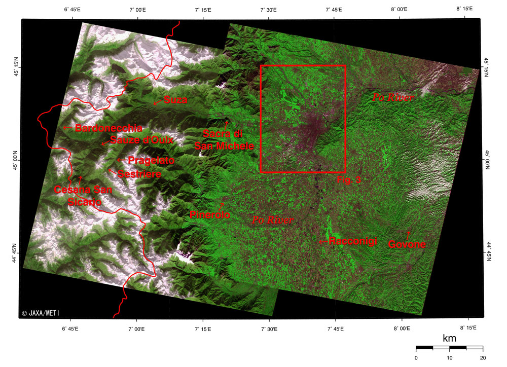
Turin, the state capital of Piedmont in northwest Italy, will soon host the 20th winter Olympic Games.

Fig. 2. Vicinity of Turin and the mountainous regions
On the left side of Fig. 2, observed in December 1994, snow covers the highlands. The urban center of Turin appears ash purple in the area just to the upper right of the center of the figure. The source of the Po River is located near the border with France, to the lower left of the figure. It flows eastward in the southern part of Pinerolo, then northeastward on the eastern side of urban Turin, and then eastward again. You can see the farmlands spreading to the south and northeast of Turin. The hills on the east side of the city hold the vineyards for the wines produced in Piedmont.

In the Torino Olympic Games, the opening and closing ceremonies and the skating competitions will be held in Turin, the curling competitions in Pinerolo, and the skiing, snow boarding, and other winter competitions in the mountainous region centered on Sestriere.

The monastery Sacra di San Michele, the most famous Benedictine abbey, is located near the entrance to the Sousa Valley on the west side of Turin.

In Racconigi to the south of Turin and in Govone to the southeast, there are castles and parks composing "Residences of the Royal House of Savoy," which was added to UNESCO's World Heritage list in 1997.

Fig. 3. Turin and vicinity
Figure 3 is an expanded image of Fig. 2. You can see Turin International Airport on the north side of the city of Turin. On the east side of the city is Basilica di Superga (Basilica Church of Superga) with the tomb of the Royal House of Savoy on the hilltop, with a bird's-eye view of the city. There are also castles, palaces and parks composing "Residences of the Royal House of Savoy" in Venaria and La Mandria to the northwest of the city, in Rivoli to the west, and in Stupinigi and Moncalieri to the south.

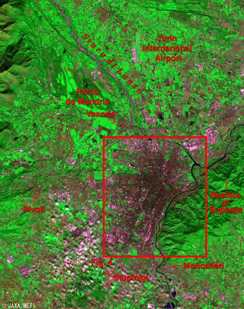
In 1562, Emmanuel Philibert, Duke of Savoy, decided to move the capital from Chambery (presently in France) to Turin. This event was an opportunity for growth, and many buildings in the baroque style were constructed based on the 17-18th century city planning in Turin and its surroundings. Therefore, Turin has orderly rows of stores and houses on streets in a grid format. The Dukedom of Savoy became the Kingdom of Sardinia after acquiring Sardinia Island in 1720. It became the Kingdom of Italy after the unification of modern Italy in 1861. Turin remained the capital seat until the capital was moved to Florence in 1865.

Fig. 4. City of Turin
Figure 4 is an expanded image of Fig. 3. You can see Stadio delle Alpi in the upper left in Fig. 4. This stadium is the home for the prestigious "Juventus Football Club," belonging to the Italian football league "Serie A," and "Torino Football Club," belonging to "Serie B." You can see the inverted letter U formed by the tracks and roads in the center of Fig. 4.
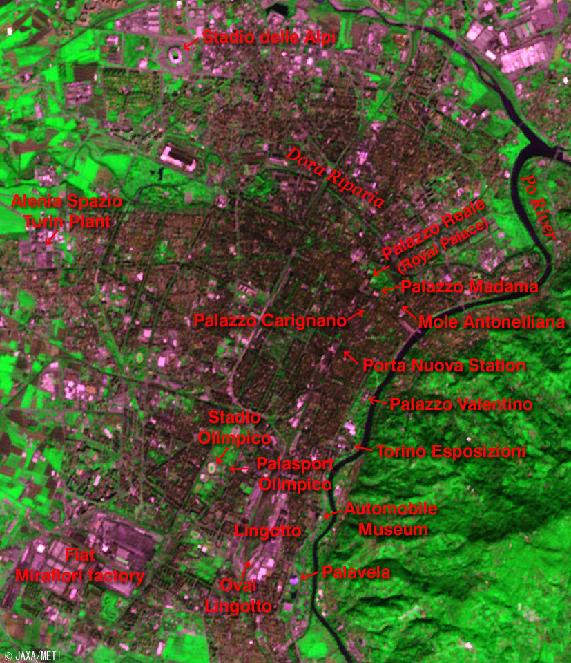
Among the "Residences of the Royal House of Savoy," the Palazzo Reale (Royal Palace), Palazzo Madama, and Palazzo Carignano, appear in the upper right of this letter U, and Palazzo Valentino appears along the Po River. Neighboring Palazzo Reale's Duomo is famous for the La Santa Sindone (Holy Shroud), which is said to have wrapped the body of Christ after His execution. Also in the upper right of the letter U is Mole Antonelliana with its 165m-high tower, the symbol of Turin. Inside Mole Antonelliana is Museo Nationale Cinema (the National Movie Museum). Turin is the birthplace of the cinema industry in Italy, and every November it hosts the "Turin International Film Festival," the largest-scale film festival following Venice. At the right end of the letter U is Porta Nuova station where international trains and long-distance trains arrive and depart. It is a one-and-a-half hour trip between Turin and Milan by Eurostar.

Stadio Olimpico where the opening and closing ceremonies of the Torino Olympic Games will be held, and Palasport Olimpico, next to the stadium, where the ice hockey games will be held, are in the lower left of the letter U. Palavela for figure skating and short-track speed skating; Torino Esposizioni for ice hockey games; and Oval Lingotto, the only newly built facility, for speed skating are in the lower right, in the Lingotto area.

The Lingotto area below the letter U is the former site of the Fiat Lingotto factory, the biggest automobile manufacturer in Italy. This area was redeveloped in the 1980s and has become a complex featuring concert halls, theaters, trade fairs, art galleries, conference rooms, shopping malls, and hotels. Fiat has become the biggest enterprise group in Italy, still dealing with automobile manufacture, but now also with aircraft manufacture, iron production, publications, finance, construction, information technology, and leisure activities. Fiat moved its headquarters to the redeveloped Lingotto area in 1997. The Automobile Museum, "Carlo Biscaretti di Ruffia," is along the Po River. The huge Mirafiori factory of Fiat can be seen at the lower left in Fig. 4.

The Turin Plant of Alenia Spazio can be seen on the left in Fig. 4. There they develop scientific satellites and manned spaceships, and their related payloads, launch vehicles, and space transportation systems and subsystems. The Multipurpose Logistic Module "Raffaello," which was manufactured there for the European Space Agency (ESA), was carried aboard Space Shuttle Discovery. It flew from July to August 2005, and docked with the International Space Station to transport water, food, equipment, and to recover garbage and used articles.

JAXA will soon launch the Advanced Land Observing Satellite (ALOS). It will carry the Advanced Visible and Near-Infrared Radiometer-2 (AVNIR-2), which is capable of 10m ground resolution. We will distribute clearer images at that time.


References:
Official site of Turin city
Residences of the Royal House of Savoy (UNESCO's World Heritage Sites)
Official site of the 20th Torino 2006 Olympic Winter Games


Explanation of the images:
Fig. 1
Satellite : Advanced Earth Observing Satellite - II (ADEOS-II) (Midori-II)
Sensor : Global Imager (GLI)
Date : August 27, 2003
Ground resolution: 250 m
Map projection: Mercator
We produced this special color composition using GLI 250m resolution channels, and assigning red to mid-infrared channel 29 (2,210nm), green to near-infrared channel 23 (825nm), and blue to visible channel 21 (545nm). This image can be interpreted as follows.

Green: Vegetation
Black or dark blue: Water surfaces
Red, brown or pink: Deserts, soil or burn scars (no vegetation)
White: Water clouds
Light blue: Snow, ice or icy clouds


Figs. 2 to 4
Satellite : Japanese Earth Resources Satellite-1 (JERS-1)
Sensor : Visible and Near Infrared Radiometer (VNIR)
Date : October 24, 1994 (Fig. 2 right, Fig. 3 and Fig. 4)
December 8, 1994 (Fig. 2 left)
Ground resolution: 18.3m x 24.2m
Map projection: Universal Transversal Mercator (UTM)
We produced the figures by assigning red to the visible channel (630 to 690nm), green to the near-infrared channel (760 to 860nm), and blue to the visible channel (520 to 600nm). The resulting figures have natural coloring with slightly emphasized vegetation, appearing as though seen with the naked eye. In these images, snow and ice are white or pale purple, city areas are ash purple, forests are dark green, grasslands and farmlands are olive green, north-side slopes are dark, and water surfaces and areas with no data are black.

Related sites:
Zoom in on the Town of Athens, Greece
Land, Seen from Space

本文ここまで。
image:Satellite Navigator
image:Satellite Applications and Operations Center(SAOC)
Earth Data Collection by JAXA Satellites
image:ページTOP