| |
 |
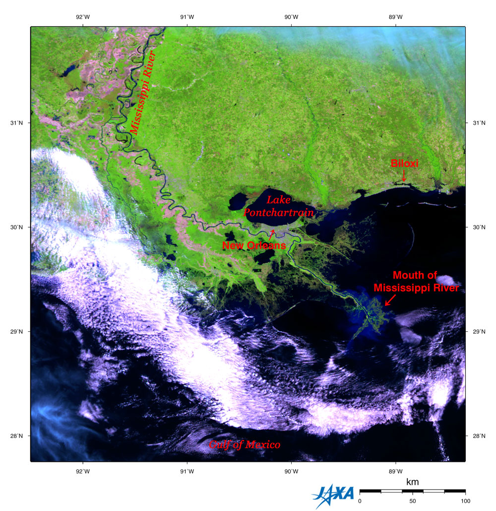
| Fig. 1 Mississippi River flowing through Mississippi and Louisiana |
Figure 1 depicts the Mississippi Basin observed by GLI aboard the Advanced Earth Observing Satellite - II in April 2003.
The olive green color represents farmland and/or grassland. Lime green color represents forests; black and dark blue represent rivers, lakes and sea; claret represents bare, non-vegetated area and cities. White and light blue represent clouds.
The Mississippi River flows from the top to the lower right of Fig. 1 and empties into the Gulf of Mexico. Near the mouth, the river appears to flow through a green pipe, and tributaries stretch in all directions like the legs of an octopus. The circumference looks dark blue. This is a huge delta area created by an accumulation of silt carried down by the Mississippi River.
The center of hurricane Katrina that devastated this area towards the end of August 2005 passed through just near New Orleans, Louisiana, and Biloxi, Mississippi. In New Orleans, a tidal bore destroyed some fragile banks and people suffered big damage from the floods. In Biloxi, a strong southerly wind created a tidal bore which brought damage to the coastline and beyond.

|
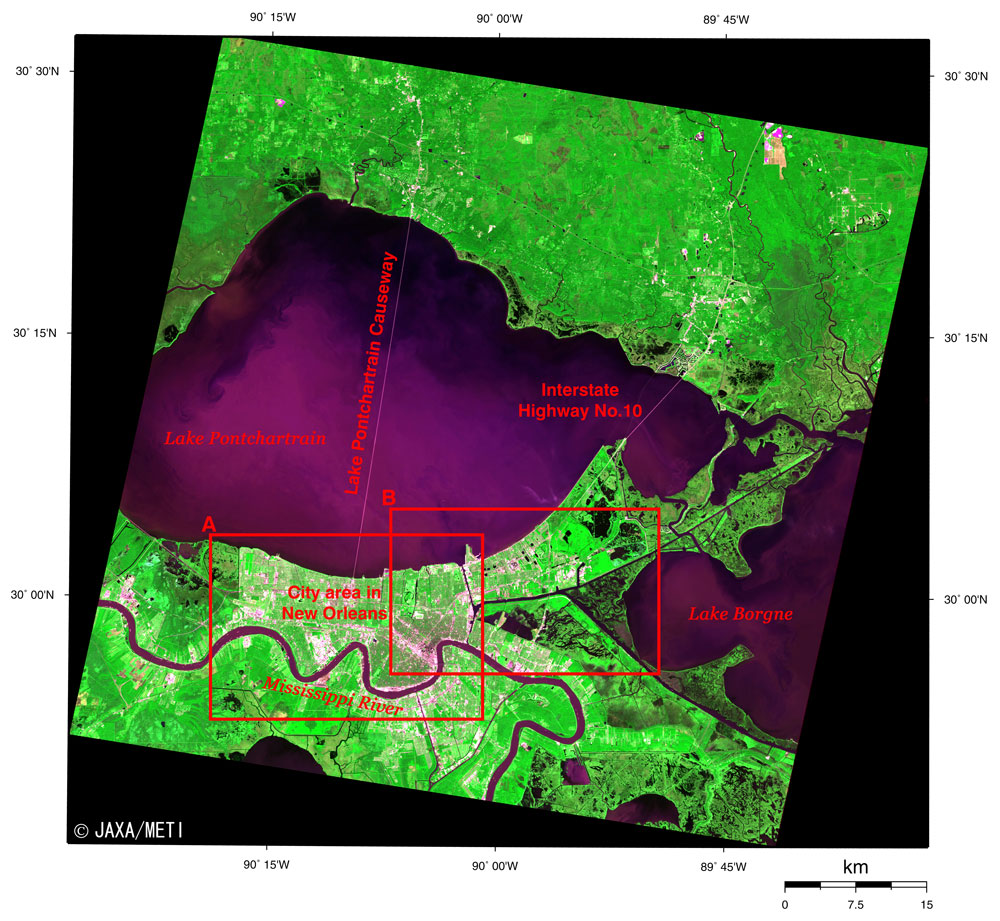
| Fig. 2 New Orleans and Vicinity |
Fig. 2 shows New Orleans and its vicinity observed by the optical sensor aboard the Japanese Earth Resources Satellite-1 in November 1993. Lake Pontchartrain is at the center of the figure, and Lake Borgne is on the right. The Mississippi River winds and flows from the lower left to the bottom of the figure. The city area in New Orleans is between Lake Pontchartrain and the Mississippi River. This whole area is a delta area on the Mississippi River with the mouth located about 130 km southeast from there. The many blackish areas around New Orleans represent spreading swamp areas.
The ashy purple straight line that links the southern coast and the northern coast of Lake Pontchartrain is the world's longest bridge, the Lake Pontchartrain Causeway. The causeway is 38.4 km long, consists of two parallel bridges having a width of two lanes and began operating in 1969. You can also see the 8.6 km long bridge of Interstate Highway No. 10 on the east side. This bridge also suffered major damage from hurricane Katrina.
Frame A is an expanded image of the city area in New Orleans. The Louis Armstrong New Orleans International Airport is on the left, and the New Orleans Lakefront Airport is in the upper right. The white circle on the right is the Louisiana Superdome where American football, baseball and basketball games are played. It is ranked as one of the world's largest stadiums and can accommodate a maximum of 79,000 people. Skyscrapers in the business area cast heavy shadows on the eastside of the Superdome. The blackish area is the busy shopping area of the "French Quarter" where Old French streets remain. The Convention Center is at the riverside of the Mississippi River. It is the seventh largest convention center in the U.S. and has conference facilities and display facilities. In addition, north of the Superdome, you can also see the City Park and the racecourse.
Frame B is an expanded image of the vicinity of the NASA Michoud assembly facility located adjacent to the canal. This huge building is used to assemble the External Tanks of the Space Shuttle. The assembled External Tank is transported by sea from here to the Kennedy Space Center in Florida. This facility also suffered damage to its roof from hurricane Katrina. It is thought that most of the NASA staff and the staff in the associated contract companies working here lost their homes. Thus, there is concern that the future of the Space Shuttle program could be in jeopardy.
JAXA will launch the Advanced Land Observing Satellite (ALOS) in the near future. It will carry the Advanced Visible and Near Infrared Radiometer Type 2 (AVNIR-2), which is capable of 10 m ground resolution. We will distribute clearer images at that time.
Our heartfelt sympathy goes out to all who suffered from this disaster, and we pray that recovery from the disaster will be soon.
Explanation of the images:
Fig. 1
| Satellite: |
Advanced Earth Observing Satellite - II (ADEOS-II) (Midori - II) |
| Sensor: |
Global Imager (GLI) |
| date: |
April 18, 2003 |
| Ground resolution: |
250 m |
| Map projection: |
Equilateral projection |
|
Color composition was made by using GLI 250 m resolution channels, and assigning red to mid-infrared channel 28 (1,640 nm), green to near-infrared channel 23 (825 nm) and blue to visible channel 22 (660 nm). In this image, vegetation is green, clouds are white or light blue, soil or sparse vegetation is brown, and water surfaces and cloud shadows are black. This is a popular color composition used for land cover survey such as vegetation classification.
|
Fig. 2, Frames A and B
| Satellite: |
Japanese Earth Resources Satellite -1 (JERS-1) |
| Sensor: |
Visible and Near Infrared Radiometer (VNIR) |
| date: |
1653 (UT) on November 1, 1993 |
| Ground resolution: |
18.3 m x 24.2 m |
| Map projection: |
Universal Transversal Mercator |
|
Fig. 2, Frames A and B were produced by assigning red to the visible channel (0.63 to 0.69 µm), green to the near-infrared channel (0.76 to 0.86 µm), and blue to the visible channel (0.52 to 0.60 µm). The resulting figures have a natural coloring, with vegetation slightly emphasized, yet still appearing as though seen with the naked eye. In these images, clouds are white, city areas are brownish, forests are dark green, grassland and farmland are light green, and water surfaces and areas with no data are black.
|
|
 |
Related Sites:
 Berlin: The city divided by a wall (part 2) Berlin: The city divided by a wall (part 2)
Berlin: The city divided by a wall (part 1)
World Heritage Site Surrounded by High-rise, Multifamily Housing: St. Petersburg
Einstein's "Miraculous Year": Bern, Switzerland
Bangkok: The Developing Capital of Angels
London: The Capital without fog
Appendices:
Brief history of New Orleans:
| |
1682 |
French explorer Robert Cavelier de La Salle named the Mississippi basin Louisiana in honor of Louis XIV. |
| |
1718 |
It was constructed by Frenchman Jean-Baptiste Le Moyne de Bienville as an important point for the traffic on the Mississippi River and Louisiana. It was in possession of the French at that time and was named La Nouvelle-Orle'ans for French Regent Philip II, duc d'Orle'ans. |
| |
1723 |
The capital of the Louisiana colony |
| |
1763 |
Louisiana became a Spanish territory |
| |
1801 |
French possession of Louisiana |
| |
1803 |
Louisiana was sold to the U.S. for 15 million dollars. |
| |
1815 |
The U.S. army led by General Andrew Jackson achieved a great victory against the British force in the Battle of New Orleans. |
| |
1849 |
Baton Rouge became the state capital |
| |
1865-1880 |
New Orleans was the state capital. |
| |
1901 |
Louis Armstrong was born in New Orleans (He died in 1971). |
| |
The beginning of the 20th century |
Jazz was born in New Orleans. |
| |
The 1910s |
The inventor Baldwin Wood implemented the plan to drain Lake Pontchartrain via canals using his originally designed pumps. |
| |
August, 2005 |
The banks of Lake Pontchartrain were burst by hurricane Katrina, and most of the city was flooded. An evacuation order was actuated. |
The Mississippi River:
The Mississippi River flows north to south between the Appalachian Mountains and the Rocky Mountains and pours into the Gulf of Mexico. There are plateaus called the Great Planes between the Mississippi River and the Rocky Mountains, and the central lowland spreads between the Mississippi River and the Appalachian Mountains. The Appalachian Mountains were formed before 225 million years ago and the Rocky Mountains were formed since 65 million years ago.
The glacier that covered the southern area of the Great Lakes during the Illinoisan glacial period (from 270 thousand years ago to 150 thousand years ago) expanded . Therefore, the river could not flow to the north, so the present basin system that consists of the Mississippi River, the Missouri River and the Ohio River flowing to the south was formed.
The source of the Mississippi River is Lake Itasca near Lake Superior, the source of the Missouri River is in the Rocky Mountains, and the source of the Ohio River is in the Appalachian Mountains. This basin system extends 6,020 km, from the Missouri River source to the Gulf of Mexico and is the third longest in the world. The area reaches 3.3 million square km (about nine times the size of the country of Japan) and is the third largest in the world. In addition, it carries approximately one billion tons of sediment every year to the Gulf of Mexico.
The largest earthquake in North America, occurred between 1811 to 1812, with the epicenter on the New Madrid Fault along the Mississippi River. It is thought to have occurred because the weight of the thick sediment carried by the Mississippi River weakened the North American Plate, and the inner portion was broken. It is also believed by some that this could occur again every few thousand years.
|
|