Seen from Space 2005
Berlin: The city divided by a wall (part 2)
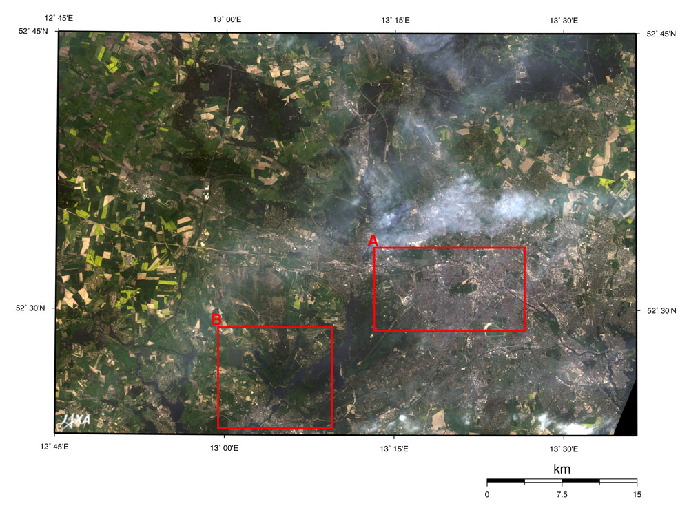
The figure depicts Berlin, Germany's capital, and its outskirts observed by the AVNIR aboard Japan's Advanced Earth Observing Satellite (Midori) in May 1997. You can see the gray city area of Berlin in the center. Potsdam, the state capital of Brandenburg, is in the lower left and looks gray with a thin cloud hanging over some of the area. The figure has a natural coloring, and appears as though seen with the naked eye. As a result, forests look dark green, and grasslands or farmlands pale green, yellow green or pale brown; it shows that forests, grasslands and farmlands spread to the suburbs. The expressways and the runways at the airports look whitish. The thick green area at the center of frame A is Tiergarten, a vast park. On the northeastern side, you can see the Spreebogen area containing the old Imperial Diet Capitol and the neighborhood of Potsdamer Platz appearing ocher in color, meaning it is under construction for redevelopment. The Berlin Philharmonic is near Potsdamer Platz. The Brandenburg Gate, which is at the eastern end of Tiergarten, became the symbol of the fall of the Berlin Wall. The Unter den Linden (meaning "under the linden") extends from the east to Museum Island, and at the north side Humboldt University looks like the letter H. There is also the Berlin Cathedral in addition to the five museums on Museum Island. If you move more towards the east, there are the television tower, the symbol of old East Germany, and Alexander Platz that was the center of politics in old East Germany. At the right end of frame A is Ost Station, the old East Berlin Central Station, which is still the starting point linking Eastern Europe and Berlin even today. The Zoo station, southwest of the Tiergarten, is the starting point to Western Europe. The Europe Center was built near there in 1965 as a showcase of capitalism against socialism and there is the Miracle mile "Kurfürstendamm" (popular name: Kudamm). West of the Tiergarten, you can see the Charlottenburg Palace built by Friedrich I who became the first Prussian king in 1701. Construction began in 1695, but several additions and enlargements created its present appearance. It was completed near the end of 18th century. The Olympic stadium is located further to the west. It was the main venue of the 1936 Olympic Games hosted under the Nazi administration in Berlin. During these Games, Ms. Maehata of Japan won a gold medal for the women's breaststroke. The final game of the World Cup Football Championship will be held here on July 9, 2006 . Frame B is the expanded image around Potsdam including "The Palaces and Parks of Potsdam and Berlin" added to the World Heritage list in 1990. Some areas were added in 1992 and later in 1999. The Sans-Souci Palace and the New Palace can also be seen. This World Heritage site consists of 500 ha park and 150 buildings that were constructed between 1730 and 1916, and they harmonize with the natural surroundings to form a unique artistic identity. The palaces and parks stand in line along the banks of the Havel River and Lake Glienicke extending to the southwest in Berlin. At the Sans-Souci Palace, which was built during 1745 to 1747, Friedrich II (the Great) deepened a friendship with Voltaire, the French philosopher and writer. The Cecilienhof Palace was originally built for the Prussian Royal Family as their residential castle, but it later became famous as the location where the leaders of the US, the UK and the USSR gathered in 1945 for the unconditional surrender of Japan in the Potsdam Conference. Next winter, JAXA will launch the Advanced Land Observing Satellite (ALOS), which will carry the Advanced Visible and Near Infrared Radiometer Type 2 (AVNIR-2). AVNIR-2 is capable of 10 m ground resolution. We will distribute clearer images at that time. References: Kido Eiichi, "Berlin the past, present and the future," San-ichi Shobou, 1998
Related Sites: Appendices: The Museumsinsel (Museum Island), Berlin: This was added to UNESCO's World Heritage list in 1999. The construction of museums came under the influence of Aufklarung during the 18th century. Five museums were built on Museum Island in Berlin between 1824 and 1930. In chronological order of their construction, they are the Old Museum, the New Museum, the Old National Gallery, the Bode Museum and the Pergamon Museum. Each museum was designed for its own collection. Capital services relocation to Berlin: The location of the Federal Government became an important issue with the reunification of Germany in October 1990. At the end of an incandescent discussion in June 1991, the Bundestag (Federal Diet)decided that the Bundestag and the majority of the Federal Government organizations would move from Bonn to Berlin. This move was almost completed by September 1999 after the international design competition in 1993. The federal agencies that moved to Berlin are as follows: The Bundestag (Federal Diet), the Bundesrat (Federal Council), the Office of the Federal President, the Federal Chancellery, the Federal Foreign Office, the Federal Ministry of the Interior, the Federal Ministry of Justice, the Federal Ministry of Finance, the Federal Ministry of Economics and Labor, the Federal Ministry for Family Affairs, Senior Citizens, Women and Youth, and the Federal Ministry of Transport, Building and Housing. The federal agencies that remained in Bonn are as follows: The Federal Ministry of Education and Research, the Federal Ministry for the Environment, Natural Conservation and Nuclear Safety; the Federal Ministry of Consumer Protection, Food and Agriculture; the Federal Ministry for Economic Cooperation and Development; the Federal Ministry of Defense; and the Federal Ministry of Health and Social Security. Capital functions were arranged in two cities. The government agencies that remained in Bonn installed branch offices in Berlin, and the government agencies in Berlin installed branch offices in Bonn. Approximately 10% of their present staff has been deployed at the branch offices. For the purpose of the capital functions relocation, the redevelopment project was implemented near the boundary between old East and West Berlin and the central area in old East Berlin. Spreebogen is one area where the River Spree bends and is the location of the old Imperial Diet Capitol. There the Bundestag (the old Imperial Diet Capitol repaired for use), and other related agencies like the Federal Chancellery were located. Another area is situated on the east side of the above mentioned area where the governmental offices' district was in old East Germany. The Ministry of Justice, the Ministry of Economics and Labor, and the Federal Foreign Office were located there. The Federal Chancellery and the Federal Foreign Office were the only government agencies with newly constructed buildings. The other agencies use renovated buildings of the old East German government. It is said that the relocation costs amounted to 20 billion marks (1,200 billion yen: 11 billion dollars). The redevelopment project containing Sony Center and the DaimlerChrysler-Area was implemented by private enterprises in the neighborhood of Potsdamer Platz. At present, the high-speed ICE (InterCity Express) train arrives at and departs from the Zoo station, connecting with Bonn in about four hours. The ICE network covers not only metropolises in Germany but also those of neighboring countries including Zürich, Switzerland and Vienna, Austria. The construction of the new station (Lehrter station) will be completed in the Spreebogen area in 2006 and will become the station terminal of the ICE. Brief history of Berlin:
|
||||||||||||||||||||||||||||||||||||||||||||||||||||||||||||||||||||||||||||||||||||||||||||