Seen from Space 2005
Innumerable Circular Farms Dot the Arabian Peninsula
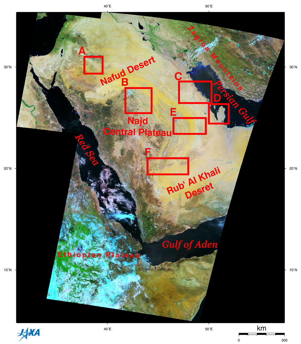
Figure 1 depicts the major portion of the Arabian Peninsula, along with the Persian Gulf and the Red Sea, observed by GLI at 250 m resolution in 2003. Most of the peninsula looks yellow or brown, signifying the vast deserts, including the An Nafud Desert in the north and the Rub' Al Khali Desert (Empty Quarter) in the south. You can find innumerable circular farms in the deserts north of the An Nafud Desert (Frame A) and on the edges of the Najd Central Plateau (Frames B, E and F). There are some burnt-umber or dark green areas, implying some vegetation from the center to the western edge of the Arabian Peninsula, along the Red Sea. Frame C indicates the many circular farms and the sets of the Trans-Arabian Pipeline and the road that stretch along the seashore and inland. Frame D includes Bahrain and Qatar, which soccer fans know well.
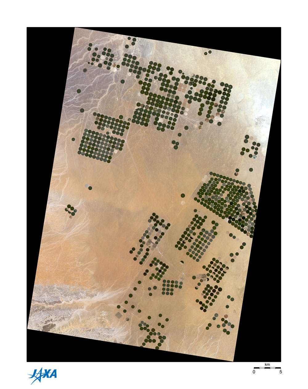
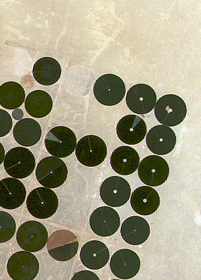
Figure 2 is an image of circular farms, captured by AVNIR at 16 m resolution in 1997, and covering the same area as part of Frame A. The sizes of these circular farms vary, and some farms are fan-shaped instead of complete circles. Some farms are brown rather than green, representing the time either before seeding or after harvest. In Fig. 3, you can see sprinklers, looking like the hands of clocks. The length of each sprinkler is the radius of its circular farm, about 350 m according to the scale bar in Fig. 2. The area of one circular farm is approximately 54 times that of a soccer field. The number of circular farms has increased intensely over the last six years, as can be seen from comparing Fig. 2 to Frame A. Farmers cultivate wheat and other crops on these circular farms, many solely by irrigating with rotating sprinklers using ground water pumped from vast aquifers. Because of this irrigation, Saudi Arabia has been able to export wheat since the middle of the 1980's. However, the ground water is fossil water (see related site), rainwater that fell ten thousand years ago when the climate was far wetter than it is now, and it was sealed in the aquifers. Some researchers predict that these ground water resources will dry up by 2040 if they continue to use the water at their present pace.
Related site: Appendices: Arabian Plate: The Arabian Peninsula, together with the African Continent, once constituted the continent of Gondwana. Volcanic activity began on the current west coast of the Arabian Peninsula 40 to 50 million years ago, and the Arabian Peninsula began to separate from the African Continent 30 million years ago, forming the Red Sea and the Gulf of Aden. The topography of the Arabian Peninsula includes an area of higher elevation on the west, along the Red Sea and an area of lower elevation on the east, facing the Persian Gulf. The mountains along the west coast were formed at that time. The Arabian Peninsula's highest peak, Mt. Nabi Su'aib (3,760 m above sea level), is located near the southernmost area of the peninsula. This zone of ancient volcanic activity continues from the southernmost end of the peninsula to the Ethiopian Plateau and the Great Rift Valley to its south. In the north, the Arabian Plate, carrying the Arabian Peninsula, has been colliding with the Eurasian Plate for about 20 million years. Therefore, the mountains and plateaus, including the very steep Zagros Mountains, formed on the north end of the Persian Gulf. The Arabian Plate continues to move north at a speed of two to three centimeters a year. Kingdom of Saba (Sheba): The Kingdom of Saba, famous for the Queen of Saba, prospered near the current Yemen. It traded olibanum, myrrh, and spice with India and the Mediterranean Sea area from the tenth to the second century B.C. The Queen of Saba ruled about 900 B.C., in the kingdom's early days. She promoted the spice industry, forming the basis for development of the kingdom. Olibanum is the gum resin of the Boswellia tree of Asia and Africa, and is milk-white with a sweet smell. It is burned as incense in religious ceremonies, used in the manufacture of perfume and medicine, and is a compounding agent for fumigation. Myrrh is another resin from a kind of balm tree, sweet-smelling and dark, reddish-brown. It is also burned as incense in religious ceremonies, used as perfume, and in sterilization. Myrrh is considered the equivalent of the ground and the body, whereas olibanum is considered the equivalent of the sky and the mind. Mocha coffee: The small port of Al-Muha, in Yemen on the Red Sea side became famous as an exporter of coffee in the 16th and 17th centuries. Therefore, the coffee grown in the mountains east of the Tihamah Plain became known as "mocha." |
|||||||||||||||||||||||||||||||||||||||||||||