Seen from Space 2005
Southward Intrusion of the Oyashio
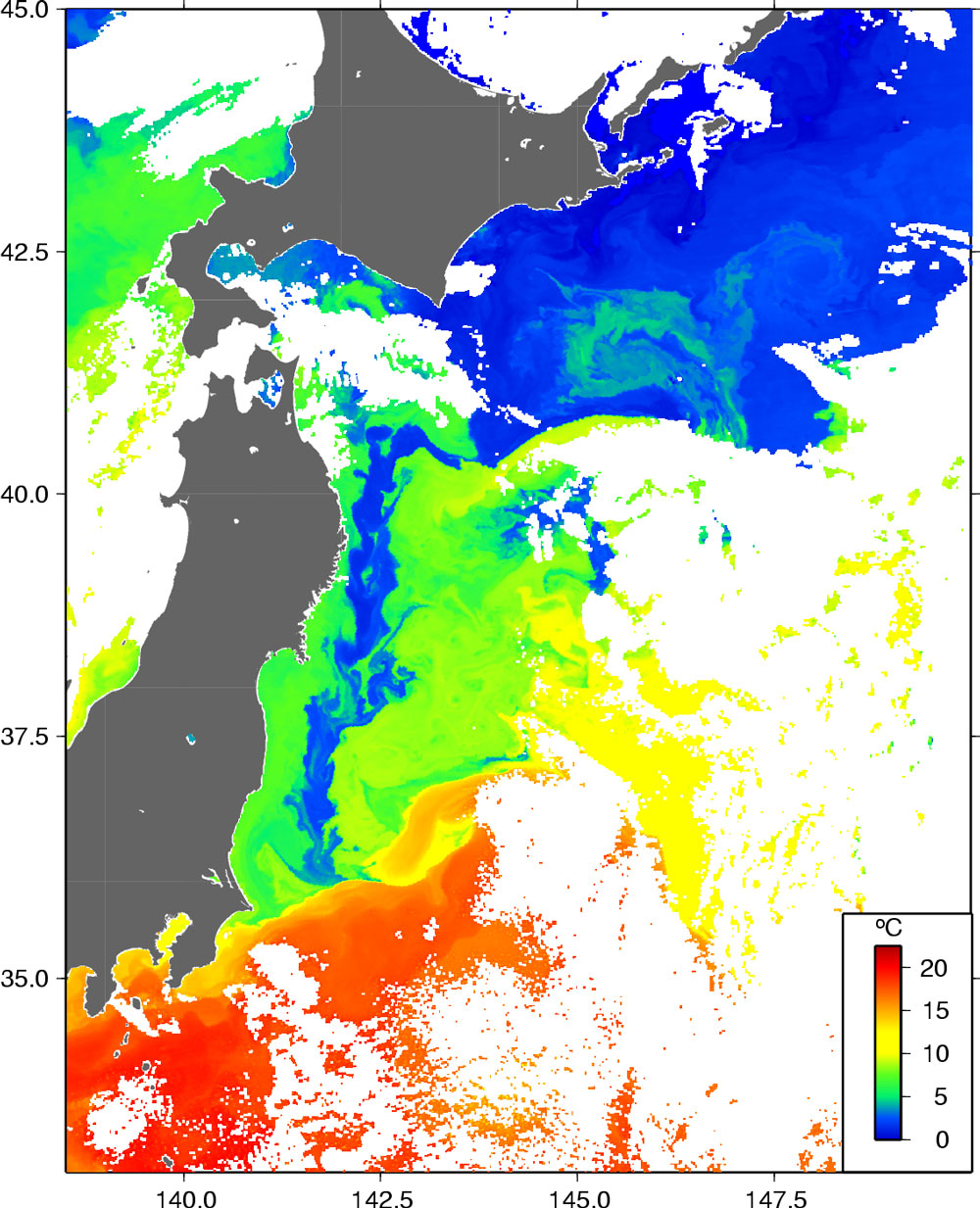
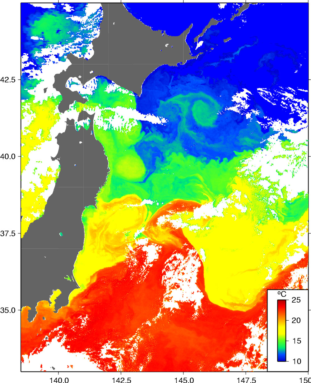
A long, cold body of water running from north to south was found off the coast of Tohoku, Japan (Fig. 1). The sea water in this area corresponds to Oyashio water, which flows southward along the Kuril Islands and the east coast of Hokkaido. (The cold-water region found in Fig. 1 is called the “First Branch of Oyashio.” *) It can clearly be seen from the figure that the Oyashio water extends to an area off the coast of Ibaraki. The region off the northeastern coast of Honshu between Kuroshio, with its warm and high-salt content, and Oyashio, with its cold and low-salt content is known as the “Mixed Water Region.” In this region, warm eddies extending from the Kuroshio and cold eddies from the Oyashio are intricately distributed. Figure 2 depicts the sea-surface temperature field observed in Nov. 2004. The southern limit of the Oyashio (represented by the blue region) is located off the coast of Iwate (about 40 degrees North) as usual. The southern limit subsequently moved further south from off the coast of Miyagi to off the coast of Ibaraki during short period from the end of January to the beginning of February 2005 .
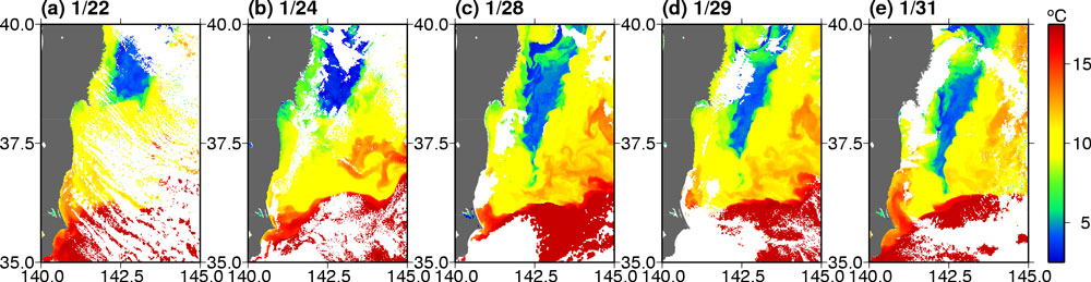
Figure 3 shows the passage on the way, Figure 3 (a) and (b) (Jan. 22 and 24) shows the southern limit of the Oyashio stayed off the Kinka-san. After that, the limit extended to an area off the coast of Fukushima, while a cold streamer was intruded into an eddy off the coast of Ibaraki (Fig.3 (c): Jan. 28). At Jan. 31, the cold water off the coast of Ibaraki broadened out to 20km (Fig. 3(e)). This phenomenon is called an “anomalous southward intrusion of the Oyashio,” which is known to be associated with the intensity of the Aleutian low. The “Monthly Report on Climate System” of the Japan Meteorological Agency pointed out that the Aleutian low was stronger than normal in October and November 2004. Therefore, the anomalous southward intrusion of the Oyashio occurred a few months after the strengthening of the Aleutian low. The southward intrusion of the cold water affects the coastal environment. The spatial distribution of fish schools changed and the fish catches were reduced in previous events. In March 2005, clione, a water creature found around Hokkaido and less common in the ocean around Honshu, was found off the coast of Ibaraki. It has been noted that if the water stays cold a cool summer occurs in the Tohoku area. A view of the sea-surface temperature observed by satellite gives a perspective on rapidly changing, small-scale oceanic phenomena. (*) First Branch of the Oyashio: The Oyashio flows southward in a few tongues to a region off the coast of Honshuu. The closest tongue of cold water to the coast is called the “First Branch of Oyashio.”
Related sites: |
|||||||||||||||||||||||||||||