Seen from Space 2005
Natural Features in Winter: The Arrival of Sea Ice to Hokkaido
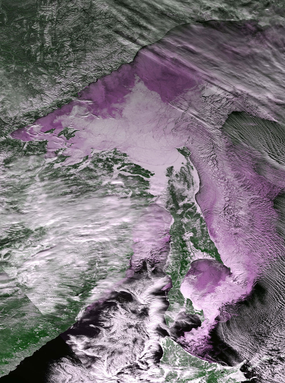
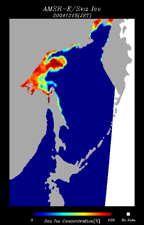
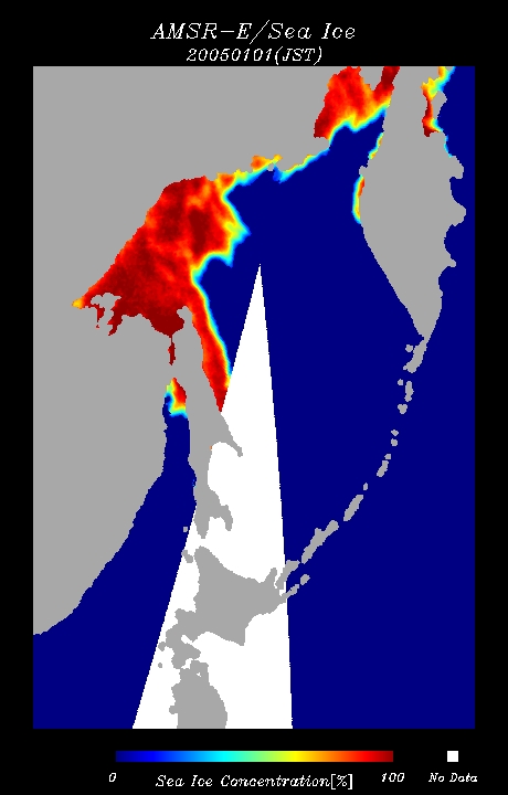
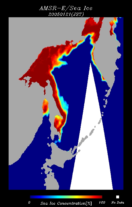
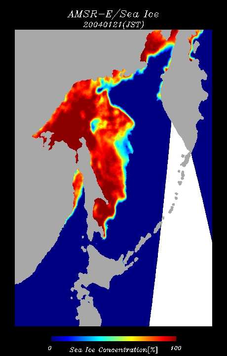
The sea ice annually approaches and reaches the coast of Hokkaido, which faces the Sea of Okhotsk. Figure 1 captured by NASA's MODIS sensor depicts the sea ice (pinkish area) floating over the Sea of Okhotsk. It shows that the sea ice generated off the Siberian coast, in the far northwest of the Sea of Okhotsk, drifts off the east coast of Sakhalin, is blown to the south by the northern wind, and approaches the coast of Hokkaido. In the expanded image you can see that the main body of the sea ice region that consists of huge groups of ice several hundred meters in diameter is still in the eastern sea off the southern end of Sakhalin. It is small ice that comes to the coast of Hokkaido, swirling as if it were white ink. In general, the sea ice moving to Hokkaido often seems to come to the south from the vicinity of the mouth of the River Amur where the ice freezes. In actuality, a lot of ice cannot be created in the mouth of the River Amur (westside of the northern end of Sakhalin) since the sea freeze and does not move there. As mentioned above, it was very recently determined that the place of origin of the sea ice is the severely cold area off the Siberian coast where the cold monsoon blows hard. In the images of the sea-ice distribution from December to January captured by AMSR-E, you see the sea ice created off the Siberian coast drifts southward off the eastside of Sakhalin (please refer to Figs. 2 to 4 and the movie).
This year, the ice reached the coast of Hokkaido seven days earlier than last year. It is understood that the sea ice area over the sea of Okhotsk was smaller in comparison to the same time last year (Fig. 5: The image on January 21 of last year). As frequently introduced on this homepage, the Sea of Okhotsk is in the lowest latitude of all the frozen seas in the world. The increase and decrease of the sea ice region is closely related to climate and catches of fish around the Islands of Japan. It is very important to monitor the growth of the sea ice over the Sea of Okhotsk in order to know the current status and future condition of the global environment. The latest information on the sea ice extending to the sea of Okhotsk is released on EORC's homepage "Sea Ice Distribution in the Sea of Okhotsk," which has been updated continuously since last year. It includes the image of the sea ice extending over the sea of Okhotsk and details the distribution of sea ice approaching the coast of Hokkaido. These details are updated daily. Moreover, you can see the change of the sea ice distribution by using the slide-show function. Please refer to the following page:
Related Sites: |
|||||||||||||||||||||||||||||