ページの先頭です。
本文へジャンプする。
【Important Notices】This page is an archive page of information published in the past. Since the update has been completed, it may contain broken links or outdated information. For the latest information, please use the new site Earth-graphy (earth.jaxa.jp).
ここからサイト内共通メニューです。
サイト内共通メニューを読み飛ばす。
サイト内共通メニューここまで。
ここから本文です。

Seen from Space 2004

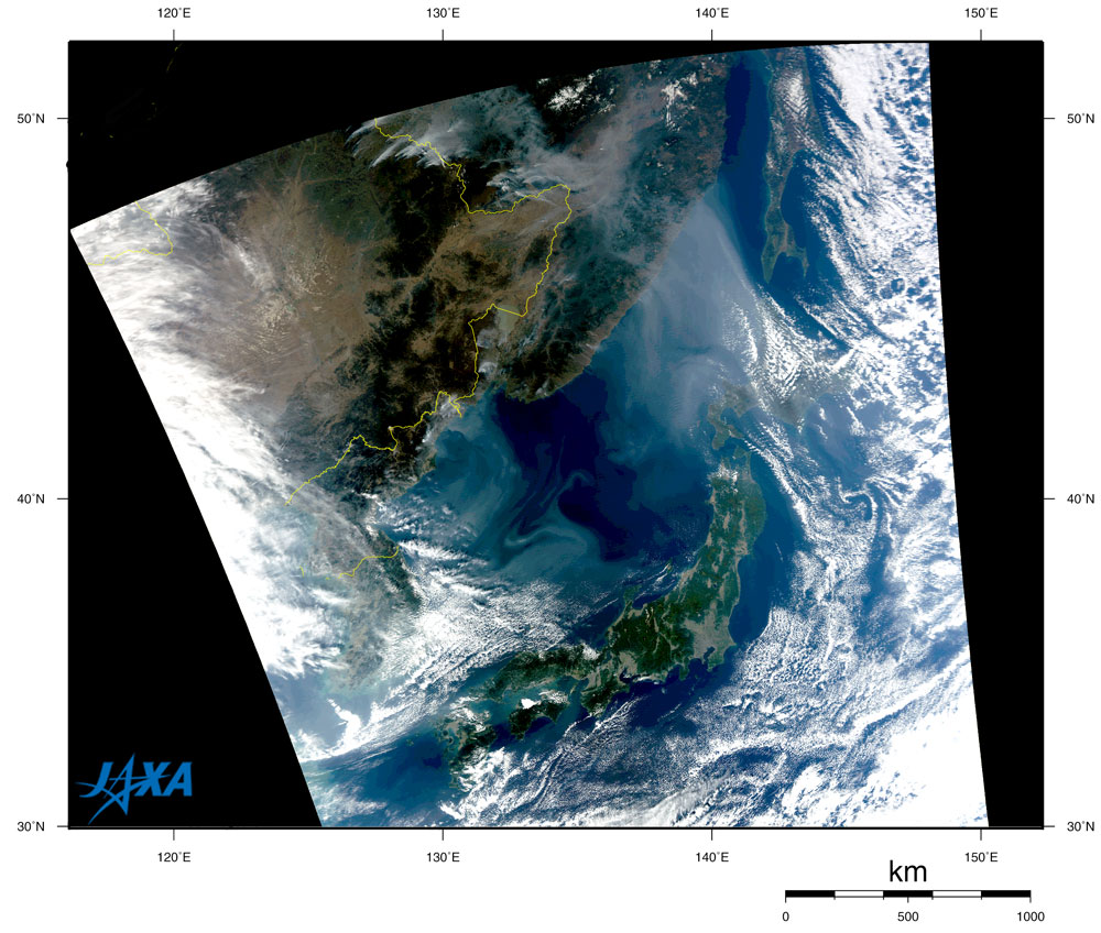
Smoke from fires in China and Russia drifts over the Sea of Japan to Hokkaido

 
Fig. 1 Smoke from fires in China and Russia
(1:00 PM October 17, 2004)

The MODIS sensor on NASA's Earth-observation satellite Aqua captured large-scale fires in a basin of the Amur River (Heilong Jiang in Chinese). Thick gray smoke from the fires drifted across the Sea of Japan and obscured the island of Hokkaido.

Figure 1 indicates that the fires developed in two clusters: a cluster in northern Heilongjiang Province (left side of the border line between China and Russia) and another cluster in the Jewish Autonomous Oblast in Russia (right side of the border line). The Amur River forms the border between China and Russia in the upper portion of this image. Smoke from these clusters of fires merged and arrived in Hokkaido island. You can also see some fires in the northeastern Democratic People's Republic of Korea and the smoke flowing eastward to the Sea of Japan.


Explanation of the images
Fig. 1
Satellite: EOS- Aqua: Earth Observing System - Aqua (NASA)
Sensor: MODIS: Moderate-Resolution Imaging Spectro-radiometer (NASA)
Time and date: 12:58 (JST) on October 17, 2004
Color composition was made by using three out of 36 channels on MODIS: channel 1 (620 to 670 nm) for red, channel 4 (545 to 565 nm) for green, and channel 3 (459 to 479 nm) for blue. As a result, the figures have a natural cloring, the same as seen with the naked eye. Clouds look white and smoke looks gray.


Related sites:
MODIS Near-real-time Images
   (Please proceed with TRIC or EOC->1km->RcRefl in the left hand side window.)
Forest Fires in Eastern Siberia
Smoke of Siberian Forest Fires Reaches Alaska
本文ここまで。
image:Satellite Navigator
image:Satellite Applications and Operations Center(SAOC)
Earth Data Collection by JAXA Satellites
image:ページTOP