Seen from Space 2004
Island floating in the Indian Ocean: Madagascar
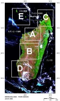
Figure 1 depicts Madagascar Island floating in the Indian Ocean southeast of the African Continent and. A deep-green belt (tropical rain forest) runs north-to-south just east of the center of the island, a green area (grass land and farmland) lies on the east side of the belt, and yellowish green and reddish brown areas (savannas, deserts and bare rocks) are seen on the west side. This indicates that the central plateau extending in a north-south direction forms the boundary between the east side wet area and the west side arid area. Baobab trees, made famous in the children's story "The Little Prince" written by Saint-Exupery, grow in this arid area. The east side of the island was reported to be once covered with rich tropical rain forest, but only one fourth or one fifth of the original forest area remains due to felling in preparation for rapid economic development. Most of the verdant east side is cutover area. Felling of the forest is driving the lemur (including aye-aye) and other animals that inhabit it into danger of extinction. White and light blue represent clouds; black represents water surfaces such as sea and lakes, or no data. A dry riverbed in the western part of the island looks whitish. Frame A is an expanded image of northwestern Madagascar. The river Betsiboka separates into many tributaries that extend from its mouth like tentacles of jellyfish. The special landform "tsingy" (reddish brown part of Frame B) that looks like a range of pinnacles made of rain-sculptured limestone is located in "Tsingy de Bemaraha National Park" in western Madagascar and is registered as a World Natural Heritage. The word "tsingy" means "to hum" in Malagasy because the limestone rocks hum when struck. Smaller scale "tsingy" are also located in Ankarana Reserve (reddish brown part of Frame C) in northern Madagascar. Frame D is an expanded image of western Madagascar, but the coloring is the nearest that seen by naked eye, unlike in the other figures and frames. The emerald-green sea stretches a total of 100 km along the seashore, and white sands on the coral reef on the shallow sea bottom glitter with reflected sunlight. Much of Madagascar consists of a Cambrian (500 to 600 million years ago) and Pre-Cambrian central plateau. The plateau was once part of the super continent, Gondwana, but it became an independent island after the break-up of Gondwana (late Jurassic; 160 million years ago) and separation from the Indian subcontinent (late Cretaceous; 90 million years ago). Therefore, many animals and plants on Madagascar Island evolved independently. The limestone structures composing "tsingy" are coral reefs that developed in the shallow sea formed during the continent break-up. "Coelacanth" (meaning "hollow spine" in Greek) has retained its original shape for over 400 million years (from the early Devonian period). They were thought to have become extinct 65 million years ago along with the dinosaurs. However, 10 to 13 coelacanth have been caught each year since 1938 near Comoro Islands northwest of Madagascar Island. They have also been caught off Kenya and near Sulawesi Island in Indonesia as well as in Mozambique Channel (see the following related site).
Related sites: |
|||||||||||||