Daily images of rainfall and sea surface temperature observed by TRMM, and satellite orbit information can be found at "Monitoring" page. Information of events such as heavy rainfall and El Nino is archived at "Topics" page.
Okinawa and Kyushu entered a stormy region of Typhoon DIANMU. The typhoon made landfall near Muroto-city, Kochi Prefecture. It then passed through the Kinki region and the Sea of Japan, causing widespread damage in western Japan where two people died, three were missing, and 87 were injured.
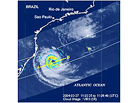
A hurricane was observed over the South Atlantic, where no tropical cyclone observed at all since 1960s when meteorological satellite observation began on March 27, 2004.
This extremely rare hurricane has observed by the Tropical Rainfall Measuring Mission (TRMM) satellite and the Aqua satellite.
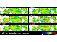
After the beginning of 2002, SSTs above those of normal years over the western tropical Pacific slowly shifted eastward. In November, an SST 2 to 3°C higher than normal is found over the central and eastern equatorial Pacific, and El Nino reached its mature stage.
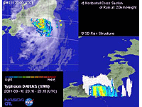
Typhoon DANAS landed at Kamakura and then hit Tokyo. It was a slow-moving typhoon, like Typhoon Pabuk. Rainfall exceeding 300mm was observed in Kanto areas along the mountains. Two people died, and four people were missing due to the mud slides.
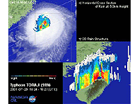
Medium-sized powerful Typhoon TORAJI landed and crossed Taiwan, causing sediment disasters in various parts of the country, due to the torrential rain. The worst-hit area is middle area of Nantou, with 119 people dead and missing in that area (214 people for all of Taiwan).
In 2000, these were many disasters caused by Asian summer monsoon in these regions. From the end of August to October in 2001, anomalous high tides over the Bay of Bengal due to the monsoon rainfall occurred frequently, and caused deluges over the islands and coasts of Bangladesh.
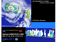
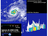
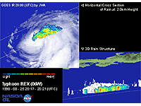
The eye of the typhoon shown here was small at the early stage, but the diameter expanded up until about 100 km in next several days as it gradually decayed. The decay can be seen from the subsiding eyewall and the weakening of the associated rainfall. The typhoon with such a large eye is unusual.
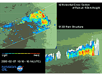
These are images of heavy rain over the frontier area of Mozambique located in southern Africa and the Republic of South Africa acquired by TRMM on February 7, 2000. TRMM/PR observes the precipitation in a wide area at rates exceeding 30mm/hour. Heavy rain fell intermittently for three weeks from Feb. 26, 2000. In February 2000, the precipitation system produced rainfall at a rate exceeding 500mm a month in the damaged area. As a result, rainwater flowed into the valley of the Limpopo River and caused a flood.
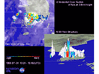
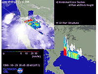
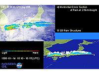
These are images of concentrated heavy rain over Korea observed by TRMM Precipitation Radar (PR) on July 31,1998 during the period 10:12 pm to 10:16 pm (JST). The heavy rain front in middle and eastern China moved to the east without weakening, bringing great damage, landslide casualties, and muddy streams to the southern part of Korea.
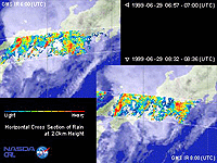
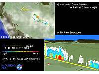
These are images of concentrated heavy rain over the west Japan observed by TRMM Precipitation Radar (PR) on June 29, 1999. A great damage was brought by this heavy rain coursed by the activated seasonal rain front(Bai-u front). Although the maximum hright of cloud tops was no more than 8km, the rain was severe enough to cause landsides in Hiroshima Prefecture.
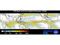
This panel shows estimated accumulated monthly rainfall at 2.0 km height derived from PR. Heavy rainfall regions were observed in the Southern Hemisphere which was in the summer season. In a normal year, heavy rainfall regions are located around the western tropical Pacific, but in February 1998, the maximum rainfall region over the equatorial Pacific moved east of date line, around 150°W at the equator.