Daily images of rainfall and sea surface temperature observed by TRMM, and satellite orbit information can be found at "Monitoring" page. Information of events such as heavy rainfall and El Nino is archived at "Topics" page.
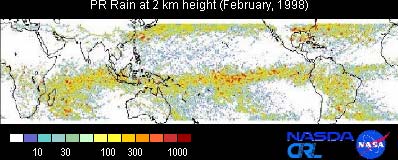
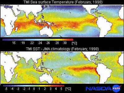
These figures indicate the variation of Sea Surface Temperature (SST) related to an El Nino warm episode and corresponding rainfall distribution in February 1998.
This panel shows estimated accumulated monthly rainfall at 2.0 km height derived from PR. Heavy rainfall regions were observed in the Southern Hemisphere which was in the summer season in this figure.
Zonal heavy rainfall regions along the equator correspond to the Intertropical Convergence Zone (ITCZ) . In a normal year, heavy rainfall regions are located around the western tropical Pacific, but in February 1998,
the maximum rainfall region over the equatorial Pacific moved east of date line, around 150°W at the equator. The El Nino warm episode is supposed to have influenced this shift. Also,
there were no rain observations in the Tibetan Plateau, the Rocky Mountains and the Andes because those regions are highlands where the altitude exceeds 2.0 km.
This image shows monthly mean rainfall anomalies estimated by the "TRMM and Others Combined" algorithm (TRMM, IR on board geostationary satellites and rain gauges). It is clear that the variation of the SST distribution corresponds well to the changes in the distribution of rainfall all over the world. In July, more rain was over the far south of Japan, and was related to the evolution of typhoons in this area. In September, peaks of rainfall were found over the central tropical Pacific, and in November, the position of the Inter-Tropical Convergence Zone (ITCZ) shifted further southward than in a normal year.