- Top
- Archives
- Precipitation climatology (10-year mean) observed by the Global Precipitation Measurement (GPM)
- Climatological data of surface precipitation distribution from GSMaP
Climatological data of surface precipitation distribution from GSMaP

Figure 1: Climatological surface precipitation distribution from GSMaP MVK(V8). The analyzed period is 10 years from March 2014 to February 2024. The unit is mm/30 days.
The tropical Pacific and Indian Oceans are characterized by heavy rainfall throughout all seasons. This is because there is an area of heavy rainfall called the Intertropical Convergence Zone (ITCZ) near the equator in the Pacific and Atlantic Oceans (5-10 degrees north latitude), and there is also an area of heavy rainfall called the South Pacific Convergence Zone (SPCZ) in the tropical South Pacific . On the other hand, over the oceans on the west coast of the continents at latitudes 10-20 degrees, subtropical high pressure develops and tends to cause less precipitation. In addition, there is an area in the eastern equatorial Pacific Ocean where sea surface temperatures are low due to the influence of equatorial upwelling and precipitation is low.
Areas of heavy precipitation are seen over the mid-latitude oceans on the east coast of the continents. This is an area where the activity of traveling synoptic-scale disturbances (high and low pressure waves) called storm tracks is active, and frontal precipitation is observed associated with the disturbances, especially in the winter hemisphere. It can be seen that there is heavy precipitation over the continents in the tropical regions of Africa and South America, and less precipitation in the Sahara Desert in northern Africa and the Arabian Peninsula.
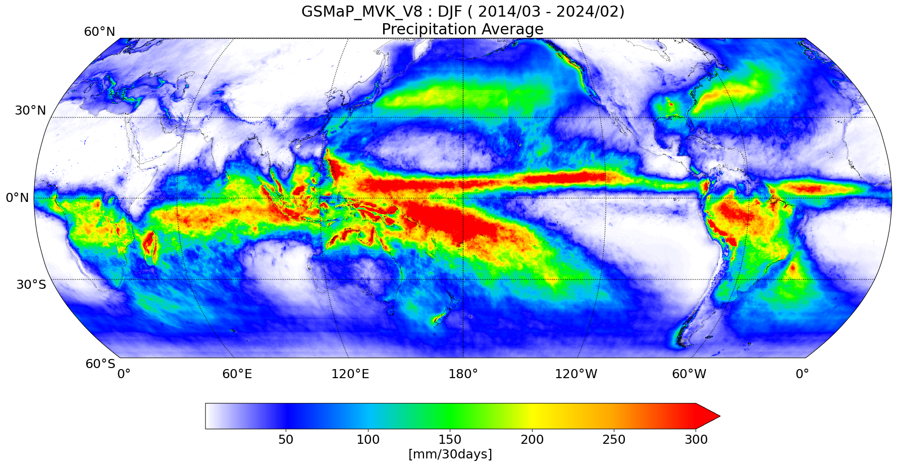
Figure 2: Climatological values for Northern Hemisphere winter (December, January, February) (observed by GSMaP_MVK)
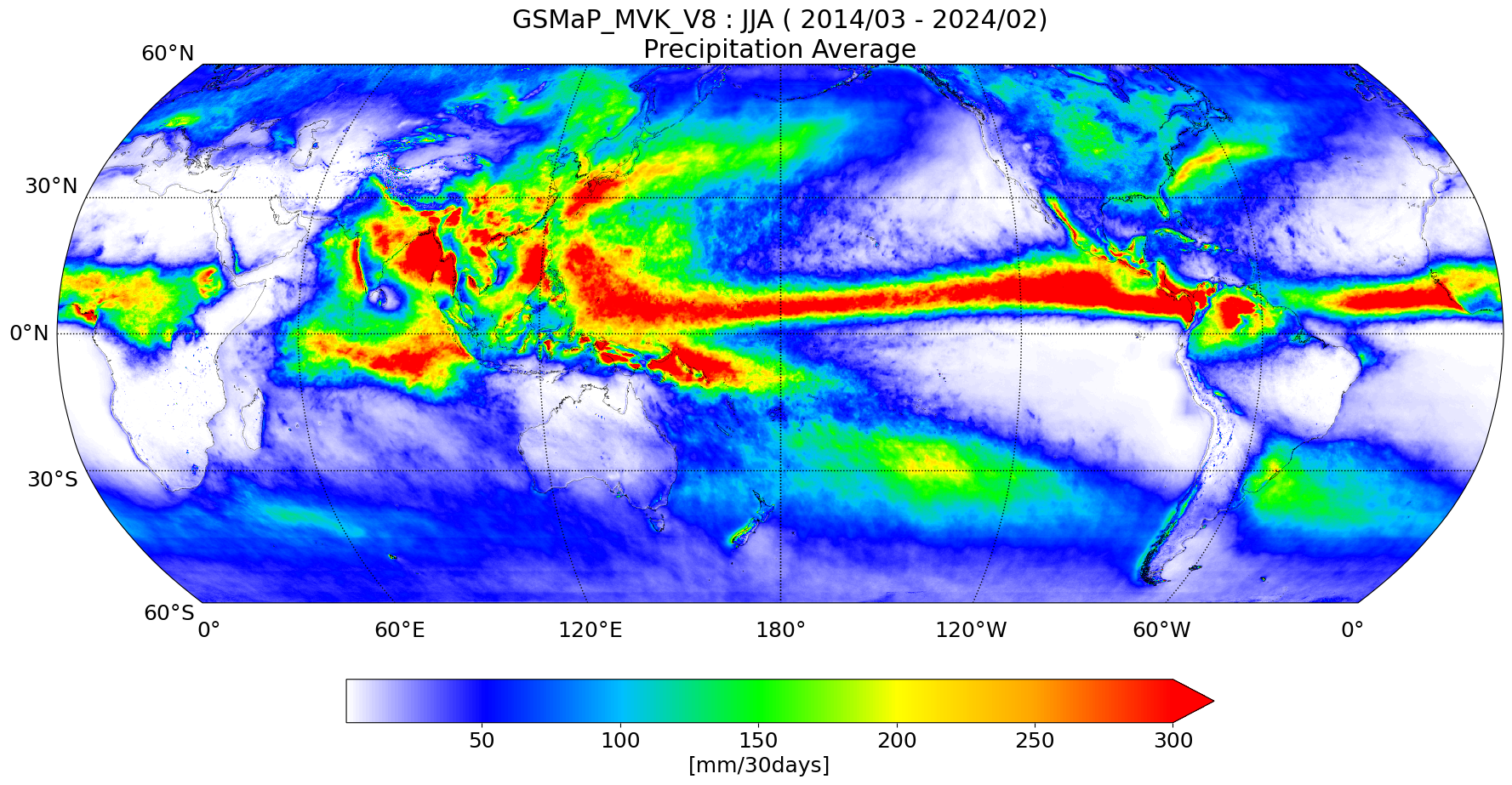
Figure 3: Climatological values for Northern Hemisphere summer (June, July, August) (observed by GSMaP_MVK)
Looking at the seasonal distribution of surface precipitation, we can see that the location and intensity of precipitation change with the season. The ITCZ is active in the northern summer (June to August), while the SPCZ is active in the southern summer (December to February), and the rain area spreads southeastward. Furthermore, in March and April, the ITCZ is distributed over the eastern Pacific Ocean not only in the northern hemisphere but also in the southern hemisphere.
In the subtropics to mid-latitudes, the difference in the distribution of precipitation by season becomes even greater. Precipitation is usually heavy in the summer hemisphere, and in the northern summer, the Asian monsoon distributes precipitation over a wide area from India to Southeast Asia and East Asia including Japan. In particular, due to the southwesterly winds of the Asian monsoon wind system, areas with significant rainfall are concentrated on the west coast of the Indochina Peninsula and the west coast of the Indian subcontinent. Conversely, in the northern winter, these areas tend to receive less rain. For example, in Africa, the Sahara Desert and its surrounding areas receive very little rain throughout the year. On the other hand, in the Southern Hemisphere, south of 10 degrees south latitude, there is a large difference in seasonal rainfall, with most rain falling in the summer. The same is true in South America, where the area from southern Brazil to Argentina also tends to receive more rain in the summer.
GSMaP is a precipitation estimation product based on 3-dimensional precipitation information observed by the DPR onboard the GPM Core Observatory, and observation data from the GPM Microwave Imager (GMI) and microwave radiometers onboard the GPM constellation satellites, and infrared radiometers onboard geostationary meteorological satellites. By using multiple microwave radiometers and infrared radiometers, global precipitation can be estimated every hour at 0.1 degree latitude and longitude grids. GSMaP can obtain global precipitation, and it has been used for monitoring heavy rain and droughts, flood predictions, agricultural fields, etc.